
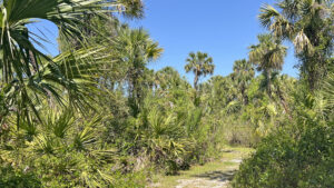
Funneling the waters of Big Slough south towards the Myakka River, Myakkahatchee Creek flows through a showy natural basin at this City of North Port park.
It’s a floodplain stream, sluggish and shallow at times, roaring through its deeply eroded curves at others.
 Alligator sunning along Myakkahatchee Creek
A trio of trails explore the surrounding landscape. The Yellow Loop follows the natural curves of the creek through a lush hardwood hammock on high banks.
Two loops off the Yellow Trail, the White and Red Trails, also wander through scrubby flatwoods and palm hammocks.
 Major junctions are well marked
A pair of bridges span the creek to create a 2.1 mile perimeter loop. If either bridge is under repair, as one was during our visit, plan on a 3.5 mile hike.
Many more miles of trails await beyond the back gate of the north parking area to the Myakkahatchee Trailhead of Big Slough Preserve.
 Myakkahatchee Creek Environmental Park provides parking for this trailhead at Big Slough Preserve
Covering over 4,700 acres, Big Slough Preserve is part of a vast puzzle of former ranches now natural lands protected by Sarasota County.
Tall and narrow, it surrounds Big Slough all the way north to SR 72, to Myakka River State Park, and adjoins both Carlton Reserve and Walton Ranch at its south end.
 A bridge for trail users connects the two public lands
Resources





Disclosure: As authors and affiliates, we receive earnings when you buy through our links. This helps us provide public information on this website.
Overview
Location: North Port
Length: 2.1 miles
Trailhead: 27.119605, -82.195250
Address: 6968 Reisterstown Road, North Port
Fees: Free
Restroom: At the trailhead
Land Manager: City of North Port
Phone: 941-861-5000
Open dawn to dusk. Leashed dogs welcome. Trails open to cyclists and equestrians. Call to reserve primitive camping at their walk-in tent sites.
Directions
From Interstate 75 exit 182, North Port, head north on Sumter Blvd. After a mile, turn left on Tropicaire Blvd. Make a right in 0.3 mile on Reistertown Rd. The park entrance is on the right within a mile, just before a sharp left curve. To hike or camp, park in the first lot. Cyclists and equestrians should continue to the second lot for the back gate to a bridge over a canal leading to the Myakkahatchee Trailhead of Big Slough Preserve.
Hike
At the south end of the parking lot, a footpath between the picnic area and composting toilet leads to the trailhead kiosk.
Grab a map or take a photo of the one on the kiosk. It’ll help with navigating past some of the side trails with no signposts.
 Trailhead kiosk
Follow the path beneath the live oaks and palms to the first glimpse of this tannic creek from its bluffs.
Sandbars appear when water levels drop, providing sunning spots for alligators and turtles.
 Myakkahatchee Creek
Broadening to the width of a forest road, the Yellow Trail remains largely shaded by the ancient oaks in this hardwood hammock.
Virginia willows sprout along the creek basin, which narrows into a tighter channel.
 The wide Yellow Trail
Myakkahatchee Creek is simply another name for Big Slough, a drainage from marshes to the north forced into a ditch by dredging long ago.
This preserve is one of the few places where the creek has once again carved its natural meanders within a channelized basin.
 Another glimpse of the creek
A quarter mile in, the channel features are more obvious from a sand bluff with a view of the trail on the opposite bluff. Continue an easy ramble under the live oaks.
In a tenth of a mile reach a junction with a bench and a signposted trail junction. Turn right to start the White Trail.
 White Trail junction
Leaving the creek behind, walk this broad path through the hardwood hammock. Dip into deep shade and emerge into a grassier area edged by a thicket of young scrub oaks.
The limbs of the live oaks sporadically shading this sunnier section are laden with bromeliads and butterfly orchids. More cabbage palms appear in the hammock.
 Under the oaks
Savor a stretch of shade through a tunnel of oak limbs. Emerge into a grassy, sun-splashed passage through the hammock.
As this short loop draws closer to its conclusion at Myakkahatchee Creek, walk through a possibly soggy spot and up a small sandy rise.
 Slight rise
Facing a split in the grassy pathway, bear left; the right side is a spur trail to Tropicaire Blvd.
Meet a sandy junction with a “Return to Parking” sign pointing left. Proceed straight ahead towards the cabbage palms.
 This bridge is under the palms
Cross the lower bridge over Myakkahatchee Creek at 0.6 mile. On the eastern shore, a signpost marks the junction of several trails.
Follow the Red / Yellow Trail signs, walking upstream not far from the bluffs to the next junction.
 Creek view from the bridge
A red-tipped post indicates the start of the Red Trail. Turn right to explore this loop. Start in the deep shade of the hardwood hammock.
Emerging into a sunnier corridor. walk among stands of cabbage palms towards an array of younger slash pines.
 Marker at the start of the Red Trail
Enter a pine-palm flatwoods, with mounds of grapevine and clusters of tall prairie grasses on either side of the footpath.
At 1.4 miles, the trail splits in front of a very large live oak with spidery limbs. Turn right.
 Junction at large oak
Walk out into a grassy clearing to a signpost for the junction of the Red and Yellow Trails. Turn right to resume the perimeter loop of the Yellow Trail.
Edged by Virginia willow, the pathway narrows and drops through a ditch, a seasonal drainage from the nearby subdivision.
 Dip through a sometimes-wet drainage
Back on level ground, resume the familiar grassy walkway under the oaks, curving past a stand of bushy bluestem grass.
Re-enter the deeper shade of the hardwood hammock, with rare glimpses of the creek while paralleling it north.
A bench in a shady spot tempts. The live oaks are larger and grander through this part of the forest.
 Hardwood hammock
Emerge into a grassy clearing with a deep cut exiting it towards the creek. Slipping into the cut, the footpath dips towards a low marshy drainage.
Climb to the shade of the oaks. Pass a signpost for the Yellow and Red Trails from the direction you’ve come, and a bench in the sun.
 Sunny bench
The sandy path is more open through this section, echoing its past as former ranchland. In the next shady hammock, look right for an oak with a hole in its trunk.
It forms what looks like an elephant’s face, complete with an appropriately proportioned trunk.
 Elephant oak
Resuming the somewhat open landscape, draw close to Myakkahatchee Creek once more.
If the bridge has been rebuilt, it’ll be obvious where to cross to complete this 2.1 mile hike.
If it hasn’t, the picnic tables of the campsite aren’t far past this intersection, a shady place to take a break.
 Primitive camping area
Without the upper bridge available, turn around at the campsite and follow the Yellow Trail downstream to the lower bridge.
Cross that bridge and make an immediate right to follow the Yellow Trail upstream to the trailhead, the necessary detour resulting in a 3.5 mile hike.
 The upper bridge was being replaced during our visit
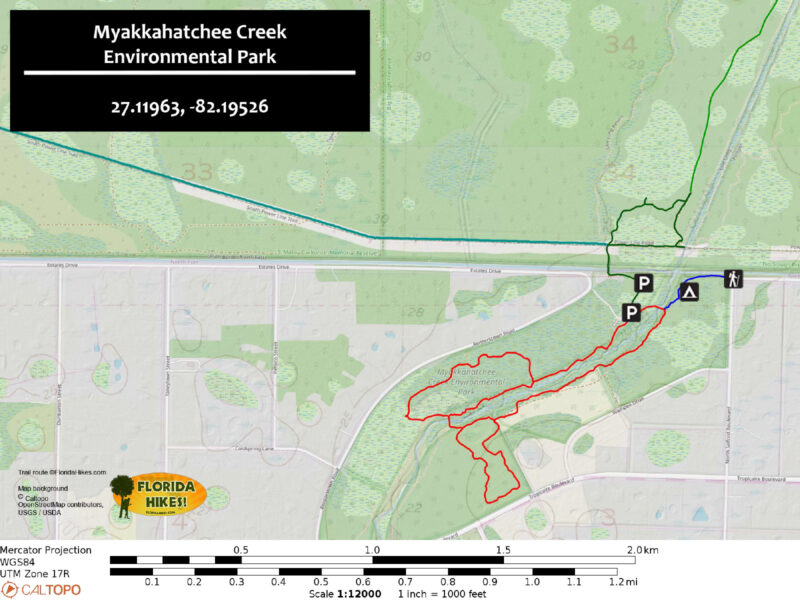
Trail Map
Explore More!
Video
Hiking Myakkahatchee Creek Environmental Park
Slideshow
See our photos from Myakkahatchee Creek Environmental Park
Nearby Adventures
 Myakka State Forest Along the southwestern Gulf Coast of Florida, Myakka State Forest offers an extensive trail network along the Myakka River basin, with tent camping under the stars.
 Jelks Preserve Offering scenic views of wild shores along the Myakka River, this hike at Jelks Preserve makes a big loop along the trail system to immerse you in a variety of habitats.
 Sleeping Turtles Preserve North Named for a feature on old navigational maps, Sleeping Turtles Preserve North provides great views of the Myakka River from its bluffs.
 Carlton Reserve Less than a dozen miles from downtown Venice, the vast expanse of T. Mabry Carlton Reserve provides regional drinking water and a massive refuge for wildlife.

- Michael Crotty Bicentennial Park - November 3, 2026
- A.J. Henry Park - November 1, 2026
- Okeeheelee Nature Center Trails - October 22, 2026