
Established in the 1930s by the Civilian Conservation Corps at the site of a town named Leno on the Santa Fe River, O’leno (Old Leno) became one of Florida’s first state parks.
Within the unique limestone topography of this basin, the Santa Fe disappears underground into the Floridan aquifer, reemerging a few miles to the south.
 Shoals in the Santa Fe River
Using native wood and limestone, CCC workers constructed many park features still standing today, including its original trails.
An extensive network of crisscrossing trails now explores both O’Leno and neighboring River Rise Preserve State Park.
The Sink to Rise Trail is the only route connecting both parks, with a backcountry campsite along the way.
 North end of the color-coded trail system
Resources





Disclosure: As authors and affiliates, we receive earnings when you buy through our links. This helps us provide public information on this website.
Overview
Location: High Springs
Length: 11.4 mile round trip
Trailhead: 29.915056, -82.580333
Address: 410 SE O’Leno Park Rd, High Springs
Fees: $5 per vehicle
Restrooms: At day use area
Land manager: Florida State Parks
Phone: 386-454-1853
Open 8 AM to sunset. Leashed dogs welcome.
Directions
From Interstate 75 exit 399, follow US 441 north into High Springs. After 5.2 miles, in downtown High Springs, US 41 merges in. Cross the Santa Fe River. Continue 4.6 miles north to Sprite Loop on the right. Take Sprite Loop 0.7 mile to a left onto O’Leno Park Rd. Continue on the main park drive for 1.9 miles to a large parking lot next to the day use area. Southbound from Lake City, use exit 414 for US 41/441 to head south 4.8 miles to Sprite Loop to reach the park entrance road.
Hike
Beginning your hike at the day use parking area, descend a grassy slope towards an iconic structure of O’Leno State Park, the CCC suspension bridge.
From here, the Sink to Rise Trail can be accessed either by following green markers for the Paraner’s Branch Trail or yellow markers for the River Trail.
 Suspension bridge over the Santa Fe
The River Trail is more scenic of the two routes, crossing a series of boardwalks alongside the cypress-lined Santa Fe River before reaching an overlook at the River Sink.
Continuing past the overlook, the trail crosses a series of bridges over seasonally dry sinkholes and rocky karst topography.
 River Sink overlook
At Ogden Lake, a long sinkhole lake interacting with water from the underground river, turn right to leave the River Trail loop.
Make another right at the next trail junction to begin the Sink to Rise Trail.
The first mile is shared with the Paraner’s Branch Trail, following an access road across mesic pine flatwoods for a mile to a sign with mileages listed for upcoming landmarks.
 Trail junction
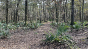
A wide sandy pathway weaves across scrubby flatwoods before entering a shady hammock alongside Jug Lake.
Another oddly narrow limestone formation, Jug Lake stretches north and south, covered in a layer of lime green aquatic vegetation.
 Jug Lake
Following orange blazed trees through the forest, head westward over undulating terrain until the trail emerges at an open scrub alongside Old Bellamy Road.
Once a highway spanning from the Ocklockonee River to St. Augustine, it crossed a natural land bridge where the Santa Fe River disappears under the earth.
 Old Bellamy Road
South of Old Bellamy Road, the trail enters River Rise Preserve, passing through a tunnel of gnarled oaks that transition to mesic flatwoods before dropping into a bottomland forest.
Under a canopy of laurel and live oaks, scattered palmettos and cypress knees dot a carpet of fallen leaves.
Waterlines on dark tree trunks reveal the occasionally flooded nature of this ecosystem.
 Bottomland forest
Ascend slightly into a mixed hardwood forest. A circle of large rocks serving as camp chairs sit near a bluff overlooking Sweetwater Lake.
This primitive backpacking campsite can be reserved at the ranger station prior to hiking.
 Primitive campsite at Sweetwater Lake
South of the campsite, navigating the route gets a bit tricker while crossing a network of mixed-use trails mostly used by equestrians.
A paper map is helpful in this section, as numbered posts correspond with numbers on the trail map.
 Numbered trail junction
Round the final corner. A sign details discoveries made about the underground section of river and its suspected path.
Beyond the sign and a wooden fence, the dark waters of the rise come into view through the trees. A set of stairs leads down the bank for a closer look at this hydrologic oddity.
 River Rise
At 5.7 miles, retrace your steps along the Sink to Rise Trail or explore the crisscrossing trail network on the way back to the trailhead.
If you hadn’t on your trip south, use the northern leg of the River Trail to return along the Santa Fe through its shady forests, crossing the swinging footbridge as a finale.
 Bottomland on the approach to the swinging bridge
Trail Map

Explore More!
Learn more about O’Leno State Park and River Rise Preserve State Park
 O’Leno State Park At the site of an 1826 pioneer community along the Old Bellamy Road connecting St. Augustine and Tallahassee, O'Leno State Park protects one of North Florida’s weirder geologic wonders, a disappearing river.
 River Rise Preserve State Park Birthing the Santa Fe River from a journey underground, River Rise Preserve State Park offers trails open to hikers and equestrians via adjoining O'Leno State Park.
Video
Hiking the Sink to Rise Trail
Nearby Adventures
 Paddling the Santa Fe River On a mellow paddling trip down the Santa Fe River, John discovers several swimming springs, thousands of turtles, and miles of quiet waterway.
 Gilchrist Blue Springs State Park Cradling a collection of spectacular springs in a forested glen along the Santa Fe River, Gilchrist Blue Springs State Park is one of the finest places to experience springs up close
 Poe Springs Park At Poe Springs Park, the Poe Springs Nature Trail carries you across a landscape shaped by water acting on limestone, where surface rock is obvious and studded with fossils.
 Mill Creek Preserve Slip through a curtain of pine plantation to discover a folded karst landscape with towering American beeches, spruce pines, swamp chestnut oaks, and a small waterfall on a 5.3 mile hike.

- Sandhill Preserve - November 9, 2026
- Calusa Heritage Trail - November 5, 2026
- Scherer Thaxton Preserve - October 21, 2026