• Skip to main content
  • Skip to header right navigation
  • Skip to after header navigation
  • Skip to site footer
Florida Hikes logo

Florida Hikes

Hike Bike Paddle Camp Florida with authors Sandra Friend and John Keatley as your guides

  • Trails
  • Maps
  • Guidebooks
  • Hike
    • Scenic Hikes
    • Loop Trails
    • Dog-friendly Hikes
    • Hikes for Kids
    • National Parks in Florida
    • Florida State Parks
  • Bike
    • Major Bike Trails
    • Paved Bike Trails
    • Off Road Biking
    • Biking Articles
  • Paddle
    • Canoe & Kayak Rentals
    • Paddling Destinations
    • Paddling Articles
  • Camp
    • Cabin Rentals
    • Car Camping
    • Primitive Camping
  • Florida Trail
    • Plan your Hike
    • Best Scenic Hikes
    • Best Backpacking
    • Section Hiking
    • Thru-Hiking
    • Trail Updates
  • Travel
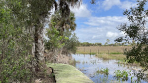
Flooded prairie next to boardwalk along palm hammock

Pepper Ranch Preserve

Miles of hiking, biking, and equestrian trails span Pepper Ranch Preserve, an important link in the Corkscrew Regional Ecosystem Watershed and habitat for the Florida panther.

Immokalee (26.437806, -81.489583)   17.6 miles  

A sprawling 2,700 acres along the shores of Lake Trafford in Immokalee, Pepper Ranch Preserve is open seasonally from November to June except during scheduled hunts.

Beyond nearly 18 miles of trails, It is known for its occasional superblooms of swamp sunflowers as well as being part of a natural lands corridor where Florida panthers roam.

Boardwalk curving past palm trees Pasture Boardwalk


Resources

Resources for exploring the region
Florida Trail Hikes book cover The Florida Trail Guide book cover South Florida Explorers Guide book cover 50 Hikes in South Florida book cover Hikers Guide to the Sunshine State book cover Paddlers Guide Florida
 
Disclosure: As authors and affiliates, we receive earnings when you buy through our links. This helps us provide public information on this website.

Overview

Location: Immokalee
Length: 17.6 miles in six trails
Visitor Center: 26.43778, -81.48956
Address: 6315 Pepper Rd, Immokalee
Fees: Free
Restroom: At the park office
Land manager: Collier County
Phone: 239-657-1999 or 239-252-2961

Open Fri, Sat and Sun from November to June, 7:30 AM to 4 PM. If the gates aren’t open, neither is the preserve.

Always check their website or call ahead before driving out, as scheduled hunts and land management activities may close the preserve on some of the above weekends.

Pets are not allowed. Visitors must sign in at the park office and obtain a day use permit before roaming the preserve. Primitive camping is available, call ahead.

Trails are often flooded after heavy rain events. Their website provides updates to the conditions of each trail.

Wet landscape at berm and fence with soggy pasture Working pastures are interspersed with natural habitats


Directions


From the intersection of Lake Trafford Rd and SR 29 in Immokalee, head west on Lake Trafford Rd for 2.9 miles before turning right onto Pepper Rd. Follow Pepper Rd for one mile until the road ends at three gates. The gate furthest to the left is the entrance to the visitor’s center and campground. Follow the dirt road for 0.2 mile to a parking area next to the office.

About the Preserve

Purchased by Collier County in 2009, the Pepper Ranch Preserve was previously owned by the Pepper family, who acquired the property in the 1920s.

Over several decades, the Peppers oversaw a fish camp, farms, cattle ranching, and oil drilling on the land. Large portions of the pastures are still used as active cattle operations.

Large cattle pasture with staring steers Cattle pasture


Framing the northeastern boundary of the Corkscrew Regional Ecosystem Watershed, the preserve is part of an extensive area of protected wetlands and a wildlife corridor extending from Estero to the Everglades.

Live oak and cabbage palm hammocks blend with mesic flatwoods at the south end, transitioning to pastureland and strand swamps on the northwest portion of the park.

Wild coffee next to a trail Wild coffee under a shady canopy


Only open on certain weekends eight months out of the year, the preserve is a quiet destination to spend a day or two exploring varied landscapes.

The extensive trail system is separated by different uses. All trails are open to hiking, although some are also designated as biking or equestrian.

Bromeliad on an oak next to a footpath Trail marker and air plant


A covered picnic area sits next to the visitor’s center, alongside the campground and a boardwalk leading to the shoreline of Lake Trafford.

A short loop trail is accessible from the campground. All other trails are located deeper in the preserve. To explore them, go into the park office to get a free permit and gate code.

Observation deck with view of vast lake Lake Trafford overlook


Hiking Pepper Ranch Preserve

Next to the visitor’s center, the 1.4 mile hiking-only Kowachobee Trail weaves through densely shaded mixed forests.

It crosses a swampy area on a sturdy bridge near the beginning of the loop. Many of the trails feature prominent map signs that show your current location on the trail.

Map box on post in forest Trail map sign on the Kowachobee Trail


Driving into the gated portion of the preserve, the Tuskawilla Trail is accessible from the first trailhead to the left.

Leading westward through mesic flatwoods and alongside depression marshes, this trail has potential to be very wet.
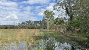
Wetland edged by pine forest Pepper Ranch Tuskawilla Trail Near the center of Pepper Ranch Preserve, the 2.2 mile Tuskawilla Trail immerses hikers and equestrians in a lush South Florida mesic flatwoods habitat.

Shared with equestrians, this route leads across to the main road on the other side of the preserve as a linear hike, or an out and back loop of 2.2 miles.

Large marsh in prairie Depression marsh on the Tuskawilla Trail


The Kite Flight Trail is the longest of the trails, tracing a large five mile loop around the pastures on the north end of the park.
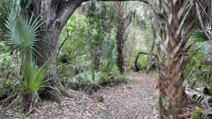
Broad path in oak and palm hammock Pepper Ranch Kite Flight Trail On the Kite Flight Trail, explore hammocks, bottomland forests, and strand swamps on a wild perimeter surrounding expansive cattle pastures at Pepper Ranch Preserve.

Shared with bikes, the paths mainly traverse berms alongside wetlands, crossing sections of water on a series of wooden bridges.

Raised berm in floodplain forest Berm on the Kite Flight Trail


Geared more towards mountain bikes, the Panther Pass and Black Bear Berm trails wind through cabbage palms and pines for 2.3 miles before returning to the trailhead.

Although well marked, navigating the route can be challenging due to the number of twists and turns.

Trailhead kiosk and signage Panther Pass and Black Bear Berm Trailhead


Nestled in the southwest corner of the preserve, the Sunflower Trace Trail is designated for hiking and equestrians.

Following a wide pathway through bottomland and mixed forest for 2.7 miles, this is the most remote trail in the park.

A few trail cameras attached to trees in this area provide pictures of endangered animals that frequent the preserve.

Camera strapped to the base of a tree in a floodplain Trail camera


Camping

Ten tent only primitive campsites circle a large field next to the visitor’s center. Each site has a fire ring and picnic table and flat grassy areas to set up a tent.

An impressive variety of songbirds, owls, eagles, and hawks frequent the camping area, and flashing patterns of fireflies add to the ambiance at night.

Reservations can be made in advance online or at the park office.

Tent set up on grass under a live oak Campsite #1


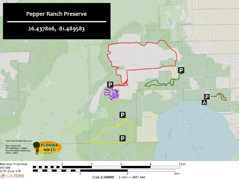
Trail Map

Pepper Ranch Preserve Trail Map
Red: Kite Flight. Purple: Panther Pass/Black Bear Berm. Yellow: Sunflower Trace. Green: Tuscawilla.
Brown: Kowachobee.

Explore More!

Video

Hiking Pepper Ranch Preserve


Nearby Adventures

Cypress dome in fog Okaloacoochee Slough State Forest Protecting the headwaters of the Big Cypress Swamp south of the Caloosahatchee River, expansive Okaloacoochee Slough State Forest preserves the heart of wild South Florida.
Cypress dome CREW Cypress Dome Trails On this 4.4 mile loop, experience an impressive array of habitats in Florida panther habitat - from sandy flatwoods to flooded cypress swamps - in the Corkscrew Regional Ecosystem Watershed.
boardwalk to big cypresses in Corkscrew Corkscrew Swamp Sanctuary Weaving beneath a canopy knit by old-growth cypress trees in a majestic swamp forest, the boardwalk at Corkscrew Swamp Sanctuary is one of Florida's best hikes.
Prairie edged by pines Florida Panther National Wildlife Refuge Explore the habitat of Florida's apex predator on a pair of short hiking trails in one small corner of the vast territory that the endangered Florida panther roams.

Trail Map (PDF) Reserve Campsite Official Website

  • Author
  • Recent Posts
Chris Stevens
Chris Stevens
Along with his wife Chelsey, Chris Stevens shares outdoor adventures on Instagram and Facebook as @sunshinestateseekers and is a co-host of a podcast about Florida's outdoors, The Florida Madcaps. An avid hiker and camper, Chris serves as a Trailmaster and a board member for the Florida Trail Association.
Chris Stevens
Latest posts by Chris Stevens (see all)
  • Oscar Scherer Green Trail - November 11, 2026
  • Sandhill Preserve - November 9, 2026
  • Calusa Heritage Trail - November 5, 2026
Category: Biking, County Parks, Day Hikes, Equestrian, Hikes, Loop Hikes, Natural Lands, Southwest Florida, TrailsTag: Best Birding, Birding, Boardwalks, Botanical, Immokalee, Observation Decks, Pepper Ranch Preserve, Primitive Camping, Wildflowers, Wildlife Viewing

Sidebar

FarOut Guides

Our comprehensive trail logistics presented on offline maps:

Florida National Scenic Trail (1,500 miles)
Florida Keys Overseas Heritage Trail (108 miles)
Eastern Continental Trail in Florida (92 miles)


We earn a small commission on sales through these links. Thanks for your support!


Our Guidebooks

We’ve written Florida guidebooks for over 25 years. These include Southwest Florida destinations.

Book cover with woman hiking through palms with baby carrier
Book cover of Florida Trail Hikes
The Florida Trail Guide fifth edition

Explore More

Newest Articles for Southwest Florida

Showy cloudscape beyond a sand road in scrub Oscar Scherer Green Trail
View of open water framed by trees Calusa Heritage Trail
Footpath dipping into dampness amid mangroves Nancy Weir Mangrove Preserve
Firebreak and grassy strip through pine flatwoods Scherer Thaxton Preserve

  • Facebook
  • Flickr
  • Instagram
  • Pinterest
  • Substack
  • Vimeo

FIND A TRAIL OR PARK

METROS: Bradenton. Clearwater. Crestview. Daytona Beach. Destin. Fort Lauderdale. Fort Myers. Fort Walton Beach. Gainesville. Jacksonville. Kissimmee. Lakeland. Melbourne. Miami. Naples. Ocala. Orlando. Panama City Beach. Pensacola. Port St. Lucie. Punta Gorda. St. Petersburg. Sanford. Sarasota. Sebring. Stuart. Tallahassee. Tampa. Vero Beach. West Palm Beach.

MULTI-REGION: Atlantic Coastal Ridge. Atlantic Coast. Bartram Trail. Big Bend. East Coast Greenway. Everglades National Park. Florida National Scenic Trail. Gulf Coast. Lake Wales Ridge. WATERWAYS: Indian River Lagoon. Intracoastal Waterway. Kissimmee River. St. Johns River. Withlacoochee River.

NORTHWEST FLORIDA: Altha. Apalachicola. Apalachicola National Forest. Big Bend Scenic Byway. Blackwater River State Forest. Blountstown. Bonifay. Bristol. Bruce. Cantonment. Cape San Blas. Carrabelle. Chattahoochee. Chipley. Crawfordville. DeFuniak Springs. Eastpoint. Ebro. Eglin Air Force Base. Freeport. Fountain. Gulf Breeze. Gulf Islands National Seashore. Holt. Madison. Marianna. Milton. Monticello. Mossy Head. Munson. Navarre. Navarre Beach. Newport. Niceville. Panacea. Panama City . Perdido Key. Ponce De Leon. Port St. Joe. Quincy. Santa Rosa Beach. Sopchoppy. South Walton. St. George Island. St. Marks. St. Marks NWR. Sumatra. Vernon. Wakulla. Wewahitchka. Woodville. WATERWAYS: Apalachicola River. Blackwater Bay. Blackwater River. Chipola River. Choctawhatchee Bay. Choctawhatchee River. Coastal Dune Lakes. Ochlockonee Bay. Perdido River. St. Marks River. Wacissa River. Wakulla River. Yellow River.

NORTH FLORIDA: Alachua. Amelia Island. Archer. Baldwin. Branford. Bronson. Bunnell. Callahan. Cedar Key. Chiefland. Crescent City. Cross City. Cross Creek. Dowling Park. Ellaville. Fanning Springs. Fernandina Beach. Flagler Beach. Fort White. Glen St. Mary. Green Cove Springs. Hawthorne. High Springs. Inglis. Jacksonville Beaches. Jacksonville Northshore. Jasper. Jennings. Keystone Heights. Lake Butler. Lake City. Live Oak.Macclenny. Mandarin. Mayo. Mayport. Micanopy. Middleburg. Old Town. Olustee. Orange Park. Osceola National Forest. Palatka. Palatka-Lake Butler Trail. Palm Coast. Palm Valley. Perry. Ponte Vedra. Rodman. Salt Springs. St. Augustine. Starke. Steinhatchee. Suwannee. Suwannee River Wilderness Trail. Suwannee Springs. Talbot Islands. Timucuan Preserve. Trenton. Waldo. Welaka. White Springs. Williston. Worthington Springs. Yankeetown. WATERWAYS: Santa Fe River. St. Marys River. Suwannee River. Tolomato River. Upper Withlacoochee River.

CENTRAL FLORIDA: Altamonte Springs. Apollo Beach. Apopka. Astatula. Astor. Auburndale. Bartow. Babson Park. Bayport. Belleview. Bithlo. Brandon. Brooksville. Bushnell. Canaveral National Seashore. Cassadaga. Christmas. Chuluota. Citrus Springs. Clearwater Beach. Clermont. Coast to Coast Trail. Cocoa. Cocoa Beach. Cross Florida Greenway. Crystal River. Dade City. De Leon Springs. DeBary. Deland. Deltona. Dunedin. Dunnellon. Edgewater. Enterprise. Eustis. Ferndale. Fort Meade. Frostproof. Geneva. Gibsonton. Haines City. Hernando. Hernando Beach. Holopaw. Homosassa. Inverness. Kenansville. Kissimmee. Lake Mary. Lake Wales. Largo. Leesburg. Lithia. Longwood. Lutz. Maitland. Malabar. McIntosh. Melbourne Beach. Merritt Island. Merritt Island NWR. Mims. Mount Dora. Narcoossee/Lake Nona. New Port Richey. New Smyrna Beach. Nobleton. Oak Hill. Oakland. Ocala National Forest. Ocklawaha. Ocoee. Oldsmar. Orange City. Ormond Beach. Osteen. Oviedo. Paisley. Palm Bay. Plant City. Poinciana. Polk City. Ponce Inlet. Port Orange. Ridge Manor. Riverview. Ruskin. Safety Harbor. Silver Springs. Sorrento. Spring Hill. St. Cloud. Tarpon Springs. Thonotosassa. Titusville . Umatilla. Viera. Walt Disney World. Weeki Wachee. Weirsdale. Wimauma. Windermere. Winter Garden. Winter Haven. Winter Park. Winter Springs. Withlacoochee State Forest. Withlacoochee State Trail. Yeehaw Junction. Zephyrhills. WATERWAYS: Alafia River. Halifax River. Hillsborough River. Lake Apopka. Little Manatee River. Ochlawaha River. Rainbow River. Tampa Bay. Wekiva River. Wekiva River Basin.

SOUTHWEST FLORIDA: Alva. Boca Grande. Cape Coral. Charlotte Harbor. Ding Darling NWR. Ellenton. Englewood. Estero. Immokalee. Marco Island. North Port. Osprey. Palma Sola. Palmetto. Pine Island. Port Charlotte. Sanibel Island. Venice. WATERWAYS: Caloosahatchee River. Manatee River. Myakka River. Pine Island Sound.

SOUTH FLORIDA: Arcadia. Basinger. Big Cypress National Preserve. Big Cypress Seminole Reservation. Big Cypress Swamp. Bowling Green. Clewiston. Everglades City. Indiantown. LaBelle. Lake Okeechobee Scenic Trail. Lake Placid. Lakeport. Moore Haven. Okeechobee. Ortona. Pahokee. Palmdale. Port Mayaca. South Bay. Wauchula. Zolfo Springs. WATERWAYS: Fisheating Creek. Lake Okeechobee. Peace River.

SOUTHEAST FLORIDA: Biscayne Bay. Biscayne National Park. Boca Raton. Boynton Beach. Coconut Creek. Coral Gables. Coral Springs. Davie. Delray Beach. Fellsmere. Flamingo. Fort Pierce. Hobe Sound. Hollywood. Homestead. Indrio. Jensen Beach. Juno Beach. Jupiter. Jupiter Farms. Key Biscayne. North Hutchison Island. Ocean to Lake Greenway. Palm Beach. Palm Beach Gardens. Pompano Beach. Redland. Sebastian. South Hutchinson Island. WATERWAYS: Florida Bay. St. Lucie River.

FLORIDA KEYS: Big Pine Key. Islamorada. Key Largo. Key West. Marathon. Overseas Heritage Trail.


©2006-2026, Sandra Friend & John Keatley | Disclosure | Site Index | Work with Us | Advertise with Us | Terms of Service and Privacy Policy

Florida Hikes PO Box 93 Mims FL 32754 | Contact