

Established in 1936, Pine Log State Forest was Florida’s very first state forest, spanning two counties 11 miles north of US 98 in Panama City Beach.
With more than 7,000 acres across southern Washington County in Ebro and northern Bay County, it’s an immense piece of public land in the midst of private timber holdings.
 Environmental Road entrance
Centered on a popular campground at Sand Pond Recreation Area, it has three distinct trailheads accessing loops optimized for hiking, off-road biking, and equestrian use.
Ebro, just a couple of miles north of the forest entrance, is a small rural town at the junction of SR 79 and SR 20 with a motel and convenience store.
 Camping at Sand Pond Recreation Area (Chris Stevens)
Resources





Disclosure: As authors and affiliates, we receive earnings when you buy through our links. This helps us provide public information on this website.
Overview
Location: Ebro
Primary trailhead: 30.429083, -85.881850
Address: 5583-A Longleaf Rd, Ebro
Fees: $2 per person at Sand Pond trailhead
Restroom: At all trailheads
Land Manager: Florida Forest Service
Phone: 850-535-2888
Day use except for registered campers and backpackers on the Florida Trail. Leashed dogs welcome.
There are multiple entrances to the forest off SR 79, Environmental Rd, and Strickland Rd in Ebro. Sand Pond Recreation Area is the primary day use area.
Spring and fall hunting seasons may impact recreational users who go farther than the Campground Trail around Sand Pond.
Directions
From Panama City Beach follow SR 79 north, passing the turnoff to the airport before you enter the state forest after 11 miles. The first two trailheads are on the right with prominent signage. Environmental Rd is on the left north of the highway bridge over Pine Log Creek. From points east or west, use SR 20 to reach Ebro and drive south on SR 79 to Environmental Road on the right. Follow it to the recreation area entrance on the right. Drive Longleaf Rd to Sand Pond Recreation Area. Pay the entrance fee and park at Sand Pond Recreation Area.
About the Forest
Sand Pond Recreation Area
One of our favorite locations for a beautifully situated campground setting, Sand Pond is a pleasant place to wake up in the morning.
Mist rising off the pond is a must-see. It’s even better on the opposite side of the recreation area from the campground, making cypress-lined Sand Pond ever so ghostly.
 Sand Pond
Wake early and loop the pond on the Campground Trail for some of the best birding in the forest.
Sand Pond Recreation Area is where three of the five trail systems within Pine Log State Forest come together.
This makes it an ideal jumping-off point for day hikes and off-road bicycle excursions, with restrooms nearby.
 Trailhead at the picnic area (Chris Stephens)
Dogwoods bloom riotously in spring around the picnic area and the massive octagonal picnic pavilion
Both are pleasant places to while away hours outdoors with friends, even if you’re not camping at Sand Pond Campground.
 Picnic pavilion
Camping
For a site at Sand Pond Campground, reserve in advance through Reserve America. Two sites – #19 and #20 – are held for walk-in visitors. Nightly rates vary from $14 to $23. A cancellation fee of $9 is charged by Reserve America.
The bathhouse is located near the Sand Pond Trailhead. It’s an older one, but was in pretty good repair last time we visited.
 Campsite at Sand Pond Campground
Its location also makes it accessible to campers utilizing the very nice group campsite located along the Campground Trail.
Another primitive group campsite, Baptism Hole, is east of SR 79 along Pine Log Creek. Access requires a gate code. Reserve both via ReserveAmerica.
 Group campsite at Pine Log
Similarly, you must reserve the three primitive campsites along Pine Log Creek online. All are along the Faye and Dutch Trail and cost $9+ per night.
You can access them by car via Hagar Landing. You’ll need to contact the forest by phone about a gate code to drive in to them.
 Campsite along the Faye and Dutch Trail (Chris Stevens)
Backpackers can use two designated primitive camping areas east along the Florida Trail, simple flat spots in the forest with no facilities.
Old Military Rd has more flat space, while Ditch Branch sits on a rise above the waterway.
 Old Military Rd camping area
Hiking
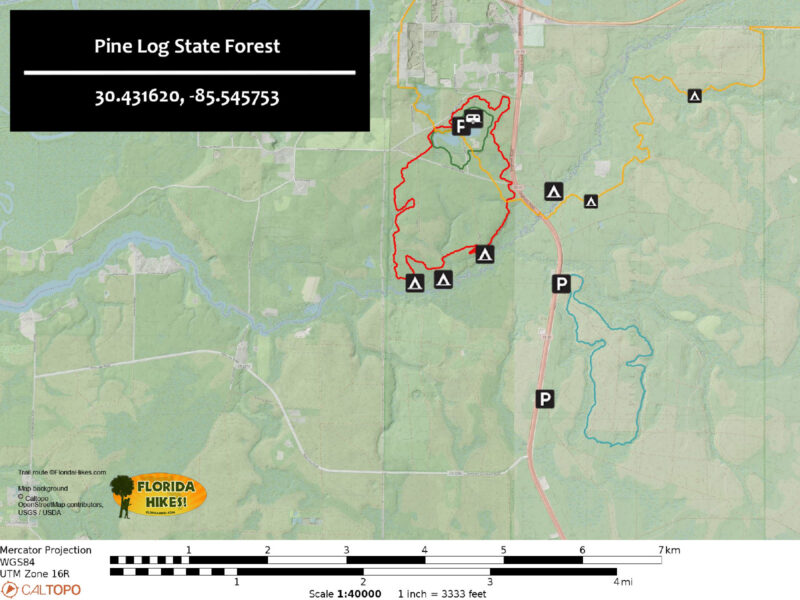
Three different hiking trails at Sand Pond Recreation Area explore the diversity of this forest.
The Campground Trail has red blazes, the Faye and Dutch Trail is blue blazed, and the Florida Trail has orange blazes.
 The trails share routes in a few places
Campground Trail
The shortest of the trio, the 1.8 mile Campground Trail is the most popular with visitors because of its shorter length and greater beauty for its distance.
It goes due west and due north from the Sand Pond trailhead. To the north, it quickly enters an uplands area with tall pines.
 Pine forest on the Campground Trail (Chris Stevens)
To the west, it curves around the edge of Sand Pond with the two other trails. They leave the pond’s edge and the Campground Trail keeps looping around the pond.
A new boardwalk through a dense cypress strand along the south shore of Sand Pond is a primary highlight of the trail.
 Cypress Pond boardwalk (Chris Stevens)
Faye and Dutch Trail
Formerly called the Tiemann Trail, this 6 mile loop is open to both hiking and off-road biking. The portion nearest the campground is through planted pines.
The remainder of the hike offers a broad range of habitat diversity to explore, including along Pine Log Creek, where primitive campsites are available.
 Faye and Dutch Trail Looping six miles through Florida’s oldest state forest, the Faye and Dutch Trail can be tackled as a day hike or a short backpacking trip.
Florida Trail
Extending 5.7 miles across Pine Log State Forest, the orange-blazed Florida Trail is part of the statewide National Scenic Trail.
There are no trailheads at either end, just gates, making a linear hike across Pine Log 7.5 miles between access points.
 Hiking through the pines
While the trail is well blazed, conditions can be rugged depending on water levels.
Titi thickets on the eastern side tend to be swampy underfoot, and the ponds from Sand Pond west sometimes flood the footpath deeply.
 Still Pond frequently swamps the trail
Most of the trail otherwise traverses pine flatwoods and sandhills, with bridges and boardwalks provided in low areas.
Hiking out and back from Sand Pond Trailhead, the only parking area along the Florida Trail route, is necessary unless you’re dropped off at a gate at either end of the forest.
 The trail follows a power line easement from SR 20 at the county line for a couple miles to reach a back gate
From the trailhead, it’s an easy 1.4 mile round-trip west along the orange blazes to the forest boundary and back.
The Florida Trail skims the edge of Sand Pond, sharing the route with the other two trails. After crossing Crews Lake Rd, it continues along the edge of Still Pond.
 Sandhills beyond the cypress ponds
Beyond this beautiful cypress-lined pond is a cypress swamp which the trail dips through. Climb into the sandhills to reach the boundary gate.
Hiking the Florida Trail east from the Sand Pond Trailhead will get you deep into the complex of ecosystems hidden within Pine Log State Forest. It’s a 10 mile round trip to the boundary.
 Longleaf restoration along the eastern boundary of the forest
There are two good intermediate turn-around points. The first is the Old Military Road, 1.6 miles east.
To reach it, the trail leads south out of the parking area, crossing Environmental Rd. It goes under SR 79 and ascends a ramp to highway level.
 Looking back at the ascent from under the highway
Use the pedestrian bridge to cross Pine Log Creek. The descent back into the forest from the highway is steep.
A pitcher plant bog and views of Pine Log Creek await at the bottom, followed by a walk through the pine forest and sandhills.
 A showy pitcher plant bloom in March
Reach the signage for the historic location of the Old Military Road, constructed between 1823 and 1824.
Enabling platoons to march from Pensacola to St. Augustine, it was the first overland route across North Florida. Turn around here for a 3.2 mile hike.
 A short stretch of the old road is signposted
Another good turnaround point is 3.3 miles from Sand Pond at Ditch Branch. Continue past Old Military Rd, following orange blazes through pine flatwoods and titi swamps.
There are several bridges to cross along the way. If any are out, you will want to turn back at that point.
 Downhill to Ditch Branch
Most of the streams are much deeper than they appear. Stick with the orange blazes along the route.
Ditch Branch is in a small ravine and the trail goes downhill sharply to the bridge. It’s an unmistakable spot.
 Side trail around Ditch Branch
The blue blaze just before the downhill is a side trail to a forest road. It provides an alternative route around the bridge in case of high water.
Use the side trail to make a loop and come back via the bridge for a 6.6 mile round-trip hike.
 Ditch Branch from the footbridge
Crooked Creek Trail
Designated Trailwalker trails for Pine Log State Forest, the Crooked Creek Trail was built for off-road cyclists but can be hiked as well.
Traversing sometimes rugged terrain around Little Crooked Creek and its tributaries, the full loop is 9 miles.
Cut that distance in half by using a blue-blazed shortcut directly across from the first equestrian trail crossing on a clockwise hike around the loop.
 Trailhead for the Crooked Creek Trail (Chris Stevens)
Old Sawmill Trail
The longest trail in the forest at 12.5 miles, the Old Sawmill Trail was established for equestrian use. It has a large parking area for horse trailers.
Follow the linear forest road out of the trailhead to start the loop. It crisscrosses the Crooked Creek Trail quite a few times.
 Start of the Old Sawmill Trail
Trail Map
Explore More!
Video
A walk along the Faye and Dutch Trail
Slideshow
See our photos of Pine Log State Forest
Nearby Adventures
 Florida Trail, Choctawhatchee River 8.5 miles. Crossing majestic longleaf pine forests in Nokuse, the Florida Trail along the Choctawhatchee River floodplain showcases natural beauty from Cypress Creek to Seven Runs.
 Florida Trail, Forgotten Creek 9.7 miles. Contrasting steephead ravines and sluggish creeks in gum swamps with longleaf pine restoration areas, the Forgotten Creek portion of the Florida Trail in Nokuse surprises with its challenges.
 Florida Trail, Econfina Creek 18.4 miles. Winding along rolling hillsides north of Panama City, the Econfina Creek section of the Florida Trail offers a challenging hike with stunning views of its namesake creek.
 Econfina Creek Nature Trail On the Econfina Creek Nature Trail, discover rugged climbs, steep drop-offs, bubbling springs, and deep crevices into the earth as you walk between two major springs where you can swim.

- Hal Scott Yellow Trail - November 3, 2026
- Hal Scott Preserve - October 28, 2026
- Tradewinds Park - October 27, 2026