• Skip to main content
  • Skip to header right navigation
  • Skip to after header navigation
  • Skip to site footer
Florida Hikes logo

Florida Hikes

Hike Bike Paddle Camp Florida with authors Sandra Friend and John Keatley as your guides

  • Trails
  • Maps
  • Guidebooks
  • Hike
    • Scenic Hikes
    • Loop Trails
    • Dog-friendly Hikes
    • Hikes for Kids
    • National Parks in Florida
    • Florida State Parks
  • Bike
    • Major Bike Trails
    • Paved Bike Trails
    • Off Road Biking
    • Biking Articles
  • Paddle
    • Canoe & Kayak Rentals
    • Paddling Destinations
    • Paddling Articles
  • Camp
    • Cabin Rentals
    • Car Camping
    • Primitive Camping
  • Florida Trail
    • Plan your Hike
    • Best Scenic Hikes
    • Best Backpacking
    • Section Hiking
    • Thru-Hiking
    • Trail Updates
  • Travel
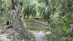
Slope to waterfront of river from bluff

Pioneer Park

A surprisingly scenic walk along the Peace River and through its floodplain, the loop trail at Pioneer Park starts and ends near the Cracker Trail Museum at Zolfo Springs.

Zolfo Springs (27.501023, -81.800373)   1.1 miles   Peace River

Fronting the Peace River west of US 17, Pioneer Park dates back to the 1930s, retaining a window to that past through wayside picnic tables, trail pavilions, and park buildings.

Its infrastructure was built by workers employed by the Federal Works Progress Administration (WPA) during the Great Depression.

Trail between river bluffs A narrows between Rock Lake and the Peace River


Access to the trail is not clearly marked, but the east end starts next to a 1935 recreation pavilion once adjoined by a swimming pool just inside the original park gates.

As the park road is just above the floodplain, we suspect it was the original SR 64, also known as the Cracker Trail. Cattle were once regularly driven to market along this route.

Log cabin with 1930s building in distance 1879 cabin and 1935 pavilion


Also along the eastern side of this large park, the Cracker Trail Museum grounds feature a collection of pioneer-era buildings, machinery, and vehicles, including a locomotive.

Both inside and outside the museum are an eclectic array of displays on the early days of pioneer settlement along the river basin.

Pioneer Park Cracker Trail Museum sign over door of older building Museum entrance


At its fairgrounds, Pioneer Park hosts major events like an annual Florida steam engine gathering. A newer RV campground sits close to the event space.

The original campground is closer to the river under the shade of ancient oaks, with a boat ramp nearby. One corner of the park is devoted to a privately managed wildlife refuge.

Boat ramp into blue waters Boat ramp on the Peace River


It’s the hiking trail, however, that makes the most of the riverfront, spanning from the museum to the boat ramp and campground through the woods.

A separate marked circuit encourages campers and day visitors to walk for exercise on the roads of the park.

Sign for walking loop Wauchula Lions Club Walking Loop


Resources

Resources for exploring the area
South Florida Explorers Guide book cover 50 Hikes in South Florida book cover Hikers Guide to the Sunshine State book cover Paddlers Guide Florida
 
Disclosure: As authors and affiliates, we receive earnings when you buy through our links. This helps us provide public information on this website.

Overview

Location: Zolfo Springs
Length: 1.1 miles
Trailhead: 27.501023, -81.800373
Address: 231 Wilbur C. King Blvd, Zolfo Springs
Fees: Free. Admission fees apply only for the Museum and Wildlife Refuge.
Restroom: Near the boat ramp
Land Manager: Hardee County
Phone: 863-473-5078

Open 7 AM to 6 PM. Leashed dogs welcome. No swimming is allowed at the park.

Campsites start at $20 plus tax and cannot be reserved in advance. Show up and check in at the park office.


Directions


Pioneer Park is at the northwest corner of US 17 and SR 64 in Zolfo Springs, 30 miles south of Bartow along US 17 or 20 miles north of Arcadia. Enter via the gate closest to the museum off SR 64 just west of the traffic light at the intersection. Park at the end of the large lot on the left closest to treeline.

Hike

From the parking area, follow the edge of the split-entry drive under the oaks and cross the park road that’s edged by forest and a grassy slope.

Descend the slope to an opening into the woods below. A thicket of wax mallow, periwinkle, and other landscaping flora crowds the sides of the trail.

Trail flanked by flowering plants Descent immediately west of the 1935 pavilion


Keep descending. The trail enters the Peace River floodplain, as evidenced by patches soft dark soil underfoot.

There is rampant growth across the forest floor. Cabbage palms and oaks make up a canopy providing deep shade.

Palm tree in green forest Walking in the floodplain


Largely grassy, the pathway winds past a murky swamp in an old oxbow of the river before making a curve towards a wooden bridge.

On the opposite side of the bridge is a T intersection, the start of the central loop of the trail at 0.2 mile. Turn right.

Bridge in forest Bridge to the loop


The landscape is a little higher in this area, the rumble of traffic from the highway bridge on US 17 carrying across the forest.

The palm hammock is punctuated by a towering, ancient live oak the trail snakes past within sight of the highway bridge.

Oak trunk with highway bridge beyond forest Base of the enormous live oak


A sharp left sets a course downriver on the bluffs of the Peace River. A study in shades of brown, the river is tannic.

It looks darker in deeper water, lighter where sandbars hover just below the surface. Etched by erosion, the far bluffs have bare limestone above the water’s edge.

Brownish river with rocky walls The river’s north bluffs


Continue through a palm hammock with lush undergrowth, the trail nicely scraped and trimmed to keep you out of the vegetation.

The far shore is fascinating, especially where clefts appear in the limestone; it’s probable the same geologic features undercut these bluffs, too.

Footpath under palms on river bluffs Following the Peace River’s flow


Curving away from the river, follow the sandy path between the palms, noting watermarks two and three feet up some trunks. If the river reaches this footpath, turn around.

A straightaway follows, the oaks and palms much taller. River glimpses are fewer, largely from beaten paths as spurs off the well-defined trail.

Sandy path through palm hammock In the palm hammock


Another jog away from the river leads down a palm-lined corridor that gains elevation, especially obvious from the next overlook.

The flood shadow in the floodplain to the left is quite striking, a reminder of how the Peace rose fast and furious during Hurricane Ian, swamping the region.

Dark bark on trees in floodplain Flood shadows on trees


Continue the climb. The next river view is through a deeply etched natural ramp to a lower bluff. Still ascending through the palms, reach a sheltered bench at 0.4 mile.

It marks the return route of the loop. Don’t turn down that slope yet, as there’s more worthwhile views up ahead.

Wooden shelter along footpath amid palms Sheltered bench at junction


Cabbage palms tower along the footpath. What appears to have been the original trail branches off, curving while descending along a showy river frontage.

The main trail is the stable one. Stick with it. Ancient saw palmetto frame a straightaway. At the next curve, that old trail is obvious on a lower bluff, partly washed away.

White sand path on river bluff The former trail eroded into the river


A shelter with a pair of benches sits on a bluff on the opposite side from the river, with water shimmering through the trees behind it.

That body of water is Rock Lake, an oxbow enhanced as part of the park infrastructure in the 1930s when picnic tables were built on its far shore.

Shelter with benches and forest view Shelter above Rock Lake


Towering palms and oaks arch overhead as the trail descends to a surprising narrows between the river and Rock Lake. The old picnic area is now a campground.

Along the narrows, enjoy commanding views down both waterways at the same time. The boat ramp defines the end of the peninsula.

Strip of trail between bodies of water Curving into the Narrows


The footpath turns and crosses a wooden bridge for access to the camping area, the finale of this end of the trail at 0.6 mile.

After taking in the full sweep of Rock Lake at the base of the campground, turn around and walk the peninsula once again, retracing your route.

Picnic table by lake Picnic and camping side of Rock Lake


Climbing the bluffs, pass the two-bench shelter and reach the single bench shelter by 0.7 mile. Take the trail to the right.

It drops quickly into the floodplain, with the glimmer of Rock Lake through the forest. Side trails lead to its edge, but they are likely places for alligators to be sunning.

Trees with path between Floodplain along Rock Lake


Continue through the lush floodplain, playing peek-a-boo with the lake and campground, the habitat shifting to palm hammock.

The flood shadow is unnervingly well overhead. Tracing a narrow waterway with a minimal flow, draw close to the edge of the campground briefly.

Trees and picnic tables beyond Campsites visible across narrow waterway


A deeper immersion in the hydric hammock follows, lush grasses obscuring the forest floor. Reach the wooden bridge at the start of the loop at 0.9 mile. Cross it.

From here, it’s a gentle walk in familiar woods to the ascent up the grassy slope to the park road for a 1.1 mile hike.

Big oak and cocoon of large green trees Ascending out of the river floodplain


Trail Map
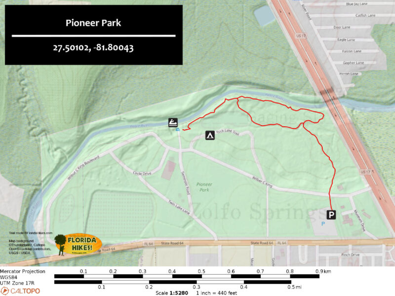
Pioneer Park Trail Map


Explore More!

Learn more about the Peace River

Bluffs above a river basin Peace River Rising from marshes in the Green Swamp basin in Lakeland, the Peace River winds through fossil-rich Bone Valley west of the Lake Wales Ridge, reaching the Gulf of Mexico at Charlotte Harbor.

Video

A walk through Pioneer Park


Slideshow

See our photos from Pioneer Park


Nearby Adventures

Riverbank view of tannic river Brownville Park Upriver from Arcadia, this 75-acre county park in the Peace River floodplain with fascinating geologic features centers on camping, paddling, and fossil hunting.
Solomon's Castle Solomon’s Castle A glimmering monument to recycling and ingenuity, Solomon's Castle is a quirky work of art. A nature trail leads along the forested edge of Horse Creek.
Myakka Canopy Walk Tower Myakka River State Park With tall waving grasses, saw palmetto, and the sound of birds, Myakka River State Park is Florida's Big Sky country, blanketing more than 37,000 acres east of Sarasota.

Official Website

  • Author
  • Recent Posts
Sandra Friend & John Keatley
Articles jointly researched, written, and photographed by Sandra Friend & John Keatley, authors and publishers of FloridaHikes.com.
Sandra Friend & John Keatley
Latest posts by Sandra Friend & John Keatley (see all)
  • Hal Scott Yellow Trail - November 3, 2026
  • Hal Scott Preserve - October 28, 2026
  • Tradewinds Park - October 27, 2026
Category: Access by water, Camping, County Parks, Day Hikes, Hikes, Launch Points, Loop Hikes, Museums, Natural Attractions, Paddling, Parks, Riverwalks, South Florida, TrailsTag: Arcadia, Big Trees, Car Camping, Geology, Historic Sites, Peace River, Scenic Hikes, Wauchula, Zolfo Springs

Sidebar

FarOut Guides

Our comprehensive trail logistics presented on offline maps:

Florida National Scenic Trail (1,500 miles)
Florida Keys Overseas Heritage Trail (108 miles)
Eastern Continental Trail in Florida (92 miles)


We earn a small commission on sales through these links. Thanks for your support!


Our Guidebooks

We’ve written Florida guidebooks for over 25 years. These include South Florida destinations.

Book cover with woman hiking through palms with baby carrier
Book cover of Florida Trail Hikes
The Florida Trail Guide fifth edition

Explore More

Newest Articles for South Florida

Shelter in cypress strand along boardwalk beside channel Lake Istokpoga Park
Waving golden grasses in a flatwoods-edged prairie Paynes Creek Flatwoods Trail
View of creek far below over railing Paynes Creek Historic Trail
Two track amid lush forest Fakahatchee East Main Trail

  • Facebook
  • Flickr
  • Instagram
  • Pinterest
  • Substack
  • Vimeo

FIND A TRAIL OR PARK

METROS: Bradenton. Clearwater. Crestview. Daytona Beach. Destin. Fort Lauderdale. Fort Myers. Fort Walton Beach. Gainesville. Jacksonville. Kissimmee. Lakeland. Melbourne. Miami. Naples. Ocala. Orlando. Panama City Beach. Pensacola. Port St. Lucie. Punta Gorda. St. Petersburg. Sanford. Sarasota. Sebring. Stuart. Tallahassee. Tampa. Vero Beach. West Palm Beach.

MULTI-REGION: Atlantic Coastal Ridge. Atlantic Coast. Bartram Trail. Big Bend. East Coast Greenway. Everglades National Park. Florida National Scenic Trail. Gulf Coast. Lake Wales Ridge. WATERWAYS: Indian River Lagoon. Intracoastal Waterway. Kissimmee River. St. Johns River. Withlacoochee River.

NORTHWEST FLORIDA: Altha. Apalachicola. Apalachicola National Forest. Big Bend Scenic Byway. Blackwater River State Forest. Blountstown. Bonifay. Bristol. Bruce. Cantonment. Cape San Blas. Carrabelle. Chattahoochee. Chipley. Crawfordville. DeFuniak Springs. Eastpoint. Ebro. Eglin Air Force Base. Freeport. Fountain. Gulf Breeze. Gulf Islands National Seashore. Holt. Madison. Marianna. Milton. Monticello. Mossy Head. Munson. Navarre. Navarre Beach. Newport. Niceville. Panacea. Panama City . Perdido Key. Ponce De Leon. Port St. Joe. Quincy. Santa Rosa Beach. Sopchoppy. South Walton. St. George Island. St. Marks. St. Marks NWR. Sumatra. Vernon. Wakulla. Wewahitchka. Woodville. WATERWAYS: Apalachicola River. Blackwater Bay. Blackwater River. Chipola River. Choctawhatchee Bay. Choctawhatchee River. Coastal Dune Lakes. Ochlockonee Bay. Perdido River. St. Marks River. Wacissa River. Wakulla River. Yellow River.

NORTH FLORIDA: Alachua. Amelia Island. Archer. Baldwin. Branford. Bronson. Bunnell. Callahan. Cedar Key. Chiefland. Crescent City. Cross City. Cross Creek. Dowling Park. Ellaville. Fanning Springs. Fernandina Beach. Flagler Beach. Fort White. Glen St. Mary. Green Cove Springs. Hawthorne. High Springs. Inglis. Jacksonville Beaches. Jacksonville Northshore. Jasper. Jennings. Keystone Heights. Lake Butler. Lake City. Live Oak.Macclenny. Mandarin. Mayo. Mayport. Micanopy. Middleburg. Old Town. Olustee. Orange Park. Osceola National Forest. Palatka. Palatka-Lake Butler Trail. Palm Coast. Palm Valley. Perry. Ponte Vedra. Rodman. Salt Springs. St. Augustine. Starke. Steinhatchee. Suwannee. Suwannee River Wilderness Trail. Suwannee Springs. Talbot Islands. Timucuan Preserve. Trenton. Waldo. Welaka. White Springs. Williston. Worthington Springs. Yankeetown. WATERWAYS: Santa Fe River. St. Marys River. Suwannee River. Tolomato River. Upper Withlacoochee River.

CENTRAL FLORIDA: Altamonte Springs. Apollo Beach. Apopka. Astatula. Astor. Auburndale. Bartow. Babson Park. Bayport. Belleview. Bithlo. Brandon. Brooksville. Bushnell. Canaveral National Seashore. Cassadaga. Christmas. Chuluota. Citrus Springs. Clearwater Beach. Clermont. Coast to Coast Trail. Cocoa. Cocoa Beach. Cross Florida Greenway. Crystal River. Dade City. De Leon Springs. DeBary. Deland. Deltona. Dunedin. Dunnellon. Edgewater. Enterprise. Eustis. Ferndale. Fort Meade. Frostproof. Geneva. Gibsonton. Haines City. Hernando. Hernando Beach. Holopaw. Homosassa. Inverness. Kenansville. Kissimmee. Lake Mary. Lake Wales. Largo. Leesburg. Lithia. Longwood. Lutz. Maitland. Malabar. McIntosh. Melbourne Beach. Merritt Island. Merritt Island NWR. Mims. Mount Dora. Narcoossee/Lake Nona. New Port Richey. New Smyrna Beach. Nobleton. Oak Hill. Oakland. Ocala National Forest. Ocklawaha. Ocoee. Oldsmar. Orange City. Ormond Beach. Osteen. Oviedo. Paisley. Palm Bay. Plant City. Poinciana. Polk City. Ponce Inlet. Port Orange. Ridge Manor. Riverview. Ruskin. Safety Harbor. Silver Springs. Sorrento. Spring Hill. St. Cloud. Tarpon Springs. Thonotosassa. Titusville . Umatilla. Viera. Walt Disney World. Weeki Wachee. Weirsdale. Wimauma. Windermere. Winter Garden. Winter Haven. Winter Park. Winter Springs. Withlacoochee State Forest. Withlacoochee State Trail. Yeehaw Junction. Zephyrhills. WATERWAYS: Alafia River. Halifax River. Hillsborough River. Lake Apopka. Little Manatee River. Ochlawaha River. Rainbow River. Tampa Bay. Wekiva River. Wekiva River Basin.

SOUTHWEST FLORIDA: Alva. Boca Grande. Cape Coral. Charlotte Harbor. Ding Darling NWR. Ellenton. Englewood. Estero. Immokalee. Marco Island. North Port. Osprey. Palma Sola. Palmetto. Pine Island. Port Charlotte. Sanibel Island. Venice. WATERWAYS: Caloosahatchee River. Manatee River. Myakka River. Pine Island Sound.

SOUTH FLORIDA: Arcadia. Basinger. Big Cypress National Preserve. Big Cypress Seminole Reservation. Big Cypress Swamp. Bowling Green. Clewiston. Everglades City. Indiantown. LaBelle. Lake Okeechobee Scenic Trail. Lake Placid. Lakeport. Moore Haven. Okeechobee. Ortona. Pahokee. Palmdale. Port Mayaca. South Bay. Wauchula. Zolfo Springs. WATERWAYS: Fisheating Creek. Lake Okeechobee. Peace River.

SOUTHEAST FLORIDA: Biscayne Bay. Biscayne National Park. Boca Raton. Boynton Beach. Coconut Creek. Coral Gables. Coral Springs. Davie. Delray Beach. Fellsmere. Flamingo. Fort Pierce. Hobe Sound. Hollywood. Homestead. Indrio. Jensen Beach. Juno Beach. Jupiter. Jupiter Farms. Key Biscayne. North Hutchison Island. Ocean to Lake Greenway. Palm Beach. Palm Beach Gardens. Pompano Beach. Redland. Sebastian. South Hutchinson Island. WATERWAYS: Florida Bay. St. Lucie River.

FLORIDA KEYS: Big Pine Key. Islamorada. Key Largo. Key West. Marathon. Overseas Heritage Trail.


©2006-2026, Sandra Friend & John Keatley | Disclosure | Site Index | Work with Us | Advertise with Us | Terms of Service and Privacy Policy

Florida Hikes PO Box 93 Mims FL 32754 | Contact
