• Skip to main content
  • Skip to header right navigation
  • Skip to after header navigation
  • Skip to site footer
Florida Hikes logo

Florida Hikes

Hike Bike Paddle Camp Florida with authors Sandra Friend and John Keatley as your guides

  • Trails
  • Maps
  • Guidebooks
  • Hike
    • Scenic Hikes
    • Loop Trails
    • Dog-friendly Hikes
    • Hikes for Kids
    • National Parks in Florida
    • Florida State Parks
  • Bike
    • Major Bike Trails
    • Paved Bike Trails
    • Off Road Biking
    • Biking Articles
  • Paddle
    • Canoe & Kayak Rentals
    • Paddling Destinations
    • Paddling Articles
  • Camp
    • Cabin Rentals
    • Car Camping
    • Primitive Camping
  • Florida Trail
    • Plan your Hike
    • Best Scenic Hikes
    • Best Backpacking
    • Section Hiking
    • Thru-Hiking
    • Trail Updates
  • Travel
Myakka Canopy Walk Tower

Myakka River State Park

With tall waving grasses, saw palmetto, and the sound of birds, Myakka River State Park is Florida’s Big Sky country, blanketing more than 37,000 acres east of Sarasota.

Across 58 square miles, the park’s enormous acreage is cradled by the flow of the Myakka River, where herons and egrets wade along the shoreline and alligators cruise the shallows.

Enjoy the wide open spaces, but don’t miss the tiny details: ferns, lichens, and mosses in the live oaks, shoelace fern dangling from the many cabbage palms.

Seasonally wet, the expansive prairies provide shelter and forage for an array of wildlife.

Sandhill cranes Myakka River State Park
Sandhill cranes gather in the prairies during the winter

Resources

Resources for exploring the area
50 Hikes in South Florida book cover South Florida Explorers Guide book cover Hikers Guide to the Sunshine State book cover Paddlers Guide Florida
 
Disclosure: As authors and affiliates, we receive earnings when you buy through our links. This helps us provide public information on this website.

Overview

Location: Sarasota
Trailhead: 27.239406,-82.316719
Address: 13208 SR 72, Sarasota FL 34241
Fees: $6 per vehicle
Restroom: At picnic areas and concession
Land manager: Florida State Parks
Phone: 941-361-6511

Open 8 AM to sunset. Leashed pets welcome but you should keep them (and small children) away from all bodies of water.

Use caution along all waterways, whether on foot or paddling. The Myakka River and its chain of lakes within this park are known for their dense alligator population. As a ranger told us, “don’t swim here.”


Directions


From Interstate 75 exit 205 at the south end of Sarasota, follow SR 72 east for 8.7 miles to the main park entrance on the north side of the highway.

About the Park

One of Florida’s oldest state parks, Myakka River State Park’s early infrastructure was built by the Civilian Conservation Corps in the 1930s.

Look for their signature picnic pavilions made of massive hand-hewn logs, and unique to this park, camping cabins constructed from palm logs.

This is a park where you can settle in for a long weekend or midweek and find plenty to do while camping.

Kayak the wild waters, sway on Florida’s first Canopy Walk between the live oaks, or take a tour on an oversized airboat to see nature in all its glory.

Tour boat Myakka River State Park
A tour boat headed into Myakka Outpost

Myakka Outpost, the concession area at Upper Myakka Lake, has a camp store and an outfitter on site with rentals.

They oversee the tour boat rides across the lake, which are 45 minutes to an hour long and run five times a day.

Myakka Outpost
Tours, rentals, a camp store and gift shop are all part of Myakka Outpost

Biking

Cyclists have an extraordinary amount of ground to cover within Myakka River State Park. Bike rentals are available at Myakka Outpost.

For those most comfortable with biking on pavement, the park’s very scenic main road is a popular destination, especially with campers.

You do need to be cautious of motorists, but there is less traffic along the North Road once you’re past the turnoff to the concession area.

In the northeast corner of the park, a set of off-road trails are accessed from the Clay Gully Trailhead.

Cyclists can ride any of the forest roads in the park, which enable you to bikepack using the same primitive campsites used by backpackers on the Myakka Hiking Trail.

Finally, there’s a day trip opportunity of 11 miles each way (22 miles round-trip) along the Myakka Island Trail along the river basin to Rye Wilderness in Venice.

Myakka River State Park bikers
Cyclists on the North Road

Birding

As we learned on a guided bird walk, you can’t go wrong birding Myakka River State Park. Pick up a birding list at the ranger station.

We stopped at a picnic area not far inside the entrance, where warblers caught everyone’s attention up in the tree canopy.

Birds at Alligator Bridge Myakka River State Park
Birds at Alligator Bridge

At Alligator Bridge, roseate spoonbills and wood storks are often seen among the alligators that rest in the shallows of the Myakka River.

Following the river bluffs, the nature trail on the northwest side of the bridge provides good sightings as well.

Farther along the scenic drive, the Bird Walk provides a gentle approach to the river for watching coots, teals, and wading birds from a boardwalk and observation platform.

Myakka Bird Walk
The Bird Walk and its observation deck

Camping

Three separate campgrounds in Myakka River State Park have a total of 90 campsites.

Old Prairie and Palmetto Ridge are the older campgrounds near the park entrance. Big Flats is near the Myakka Outpost.

Big Flats is appealing for tent camping because of its live oak canopy and the breeze off the river. Old Prairie is also nicely tucked in the woods.

Myakka River State Park outdoor movies
Movies are shown outdoors at this theater at Old Prairie

Being more open, Palmetto Ridge is better for RVs and trailers.

The CCC-era palmetto log cabins are a step back in time. The five cabins sit on rock pilings under the forest canopy. One cabin is accessible.

They do have air conditioners, but are otherwise very rustic, with a simple equipped kitchen and a pretty fireplace as well as a bathroom.

CCC building at Myakka River State Park
Palm log exterior of a CCC-constructed building at Myakka River State Park

Equestrian Use

There are nearly 16 miles of designated equestrian trails within Myakka River State Park. The horse trails have a separate entrance east of the park entrance along SR 72.

Stop in at the ranger station in advance to register and receive a combination to the lock so you can drive in to the horse trailer parking area.

Equestrians are also permitted to ride the Myakka Island Trail south of SR 72, a 22-mile round trip along the river floodplain to Carlton Reserve in Venice. In the reserve, more than 100 miles of trails are available.

Equestrian Trail Map (PDF)

Myakka River State Park backcountry
Many miles of prairie await along the backcountry trails

Hiking

Hikers have options at Myakka River State Park ranging from an easy accessible boardwalk to multiple days of backpacking the backcountry.

Nature Trails

Of the nature trails we’ve explored at Myakka River State Park, the Canopy Walk is the most compelling because of its incredible views from the tower.

It’s part of a slightly longer loop, an interpretive trail called the William S. Boylston Nature Trail.

Palm hammock at Myakka River State Park
Palm hammock along the Riverwalk nature trail

Birders also appreciate the Myakka River River Walk and the Bird Walk, both shorter pathways to excellent birding sites along the river.

Myakka Canopy Walk Bridge Myakka River Canopy Walk At Myakka River State Park in Sarasota, the Canopy Walk provides a sky-high view of the Myakka River basin as well as an intimate immersion in the live oak canopy in a beautiful hammock of oaks and palms.

Myakka Hiking Trail

Built and maintained by the Florida Trail Association, the Myakka Hiking Trail is one of the longest loop trails in Florida, totaling 39 miles in a chain of four loops.

At one point along it, you can see two miles across an open prairie. Portions of it can get very wet.

Six backcountry campsites are along the loops. Our favorite – and one of the more popular – is Bee Island.

Myakka River State Park primitive camping
Morning mist at Bee Island primitive campsite

A network of forest roads open to cyclists parallel the hiking trail, so bikepackers share the campsites.

All campsites must be reserved in advance before you set out along the trail. Only three of the campsites have pitcher pumps. All water must be treated.

Sunrise at Bee Island Myakka Hiking Trail For immersion in the vast central prairies of the Florida peninsula, the 39-mile Myakka Hiking Trail is a serious backpacking destination in South Florida near Sarasota.
Myakka River State Park Backpacking Myakka River State Park With 39 miles in four loops, the Myakka Hiking Trail at Myakka River State Park in Sarasota is one of the state's finest destinations for a weekend or long weekend holiday hike.

Wilderness Preserve

Entry to the Wilderness Preserve area south of SR 72 and east of the Myakka Island Trail requires a permit from the park office, issued in the morning until they run out of slots for the day.

The group campground is located here. Forest roads are open to hiking but not biking. A popular destination is Deep Hole, notable for its sizable alligator population.
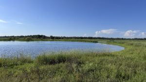
Rounded open water amid grassland Deep Hole An impressively deep riverside sinkhole within Myakka River State Park, Deep Hole provides a year-round home to some of the park's largest alligators.

Myakka Island Trail

The Myakka Island Trail stretches 11 miles between SR 72 and Carlton Reserve east of Venice. It is open to both cyclists and hikers for day use.

North access is via Martin’s Gate along SR 72, east of the main entrance to Myakka River State Park. South access is via Carlton Reserve.

Myakka Island Trail
On the Myakka Island Trail, a Sarasota County greenway

Paddling

The Myakka River flows for 14 miles through the state park, but portions of it are more suitable for paddling than others.

Water levels vary seasonally so what is good at one time of year may not work during a drier season.

Watch the weather, too, as wind can be a big issue if you get out on the open water of the larger lakes, particularly Upper Myakka Lake.

The folks at the Myakka Outpost can point out the best places to launch. Bring a canoe or kayak or rent one from them.

Paddlers may not go south of SR 72 without a Wilderness Area permit.

Myakka River State Park paddlers
Paddlers on Upper Myakka Lake

Trail Map

Myakka River State Park Trails Map
Orange: Myakka Hiking Trail. Light blue: Multiuse Trails. Purple: Deep Hole.
Red: Myakka River Riverwalk. Green: Canopy Walk. Blue: Bird Walk.

Explore More!

Video

Exploring Myakka River State Park

Slideshow

See our photos from Myakka River State Park


Nearby Adventures

Wetlands at Celery Fields Celery Fields A historic agricultural area transformed into a haven for birders, Celery Fields offers easy walking, running, and biking on paved and unpaved trails built around restored wetlands.
Trail through scrub habitat Wingate Creek State Park Named after a blackwater stream at the headwaters of the Myakka River, Wingate Creek State Park showcases natural scrub communities home to the rare and endangered Florida scrub-jay.
Prairie lined with palms Carlton Reserve Less than a dozen miles from downtown Venice, the vast expanse of T. Mabry Carlton Reserve provides regional drinking water and a massive refuge for wildlife.
Trail through open pine flatwoods in palmettos Myakka State Forest Along the southwestern Gulf Coast of Florida, Myakka State Forest offers an extensive trail network along the Myakka River basin, with tent camping under the stars.

Trail Map (PDF) Reserve Campsite Official Website

  • Author
  • Recent Posts
Sandra Friend & John Keatley
Articles jointly researched, written, and photographed by Sandra Friend & John Keatley, authors and publishers of FloridaHikes.com.
Sandra Friend & John Keatley
Latest posts by Sandra Friend & John Keatley (see all)
  • Baseline Trails - November 7, 2026
  • Hal Scott Yellow Trail - November 3, 2026
  • Hal Scott Preserve - October 28, 2026
Category: Backpacking, Biking, Camping, Canoe & Kayak Rentals, Day Hikes, Equestrian, Florida State Parks, Hikes, Loop Hikes, Nature Trails, Paddling, Parks, Southwest FloridaTag: Alligators, Arcadia, Best Birding, Best Camping, Big Trees, Birding, Boardwalks, Boating, Bradenton, Cabins, Car Camping, Developed Camping, Dog-friendly, Favorites, Fishing, Florida State Parks, Group Camping, Guided Tours, Myakka River, Observation Decks, Observation Towers, Picnic, Playgrounds, Primitive Camping, Sarasota, Trams, Waterfront, Wildlife Viewing

Sidebar

FarOut Guides

Our comprehensive trail logistics presented on offline maps:

Florida National Scenic Trail (1,500 miles)
Florida Keys Overseas Heritage Trail (108 miles)
Eastern Continental Trail in Florida (92 miles)


We earn a small commission on sales through these links. Thanks for your support!


Our Guidebooks

We’ve written Florida guidebooks for over 25 years. These include Southwest Florida destinations.

Book cover with woman hiking through palms with baby carrier
Book cover of Florida Trail Hikes
The Florida Trail Guide fifth edition

Explore More

Newest Articles for Southwest Florida

View of open water framed by trees Calusa Heritage Trail
Footpath dipping into dampness amid mangroves Nancy Weir Mangrove Preserve
Firebreak and grassy strip through pine flatwoods Scherer Thaxton Preserve
Rounded open water amid grassland Deep Hole

  • Facebook
  • Flickr
  • Instagram
  • Pinterest
  • Substack
  • Vimeo

FIND A TRAIL OR PARK

METROS: Bradenton. Clearwater. Crestview. Daytona Beach. Destin. Fort Lauderdale. Fort Myers. Fort Walton Beach. Gainesville. Jacksonville. Kissimmee. Lakeland. Melbourne. Miami. Naples. Ocala. Orlando. Panama City Beach. Pensacola. Port St. Lucie. Punta Gorda. St. Petersburg. Sanford. Sarasota. Sebring. Stuart. Tallahassee. Tampa. Vero Beach. West Palm Beach.

MULTI-REGION: Atlantic Coastal Ridge. Atlantic Coast. Bartram Trail. Big Bend. East Coast Greenway. Everglades National Park. Florida National Scenic Trail. Gulf Coast. Lake Wales Ridge. WATERWAYS: Indian River Lagoon. Intracoastal Waterway. Kissimmee River. St. Johns River. Withlacoochee River.

NORTHWEST FLORIDA: Altha. Apalachicola. Apalachicola National Forest. Big Bend Scenic Byway. Blackwater River State Forest. Blountstown. Bonifay. Bristol. Bruce. Cantonment. Cape San Blas. Carrabelle. Chattahoochee. Chipley. Crawfordville. DeFuniak Springs. Eastpoint. Ebro. Eglin Air Force Base. Freeport. Fountain. Gulf Breeze. Gulf Islands National Seashore. Holt. Madison. Marianna. Milton. Monticello. Mossy Head. Munson. Navarre. Navarre Beach. Newport. Niceville. Panacea. Panama City . Perdido Key. Ponce De Leon. Port St. Joe. Quincy. Santa Rosa Beach. Sopchoppy. South Walton. St. George Island. St. Marks. St. Marks NWR. Sumatra. Vernon. Wakulla. Wewahitchka. Woodville. WATERWAYS: Apalachicola River. Blackwater Bay. Blackwater River. Chipola River. Choctawhatchee Bay. Choctawhatchee River. Coastal Dune Lakes. Ochlockonee Bay. Perdido River. St. Marks River. Wacissa River. Wakulla River. Yellow River.

NORTH FLORIDA: Alachua. Amelia Island. Archer. Baldwin. Branford. Bronson. Bunnell. Callahan. Cedar Key. Chiefland. Crescent City. Cross City. Cross Creek. Dowling Park. Ellaville. Fanning Springs. Fernandina Beach. Flagler Beach. Fort White. Glen St. Mary. Green Cove Springs. Hawthorne. High Springs. Inglis. Jacksonville Beaches. Jacksonville Northshore. Jasper. Jennings. Keystone Heights. Lake Butler. Lake City. Live Oak.Macclenny. Mandarin. Mayo. Mayport. Micanopy. Middleburg. Old Town. Olustee. Orange Park. Osceola National Forest. Palatka. Palatka-Lake Butler Trail. Palm Coast. Palm Valley. Perry. Ponte Vedra. Rodman. Salt Springs. St. Augustine. Starke. Steinhatchee. Suwannee. Suwannee River Wilderness Trail. Suwannee Springs. Talbot Islands. Timucuan Preserve. Trenton. Waldo. Welaka. White Springs. Williston. Worthington Springs. Yankeetown. WATERWAYS: Santa Fe River. St. Marys River. Suwannee River. Tolomato River. Upper Withlacoochee River.

CENTRAL FLORIDA: Altamonte Springs. Apollo Beach. Apopka. Astatula. Astor. Auburndale. Bartow. Babson Park. Bayport. Belleview. Bithlo. Brandon. Brooksville. Bushnell. Canaveral National Seashore. Cassadaga. Christmas. Chuluota. Citrus Springs. Clearwater Beach. Clermont. Coast to Coast Trail. Cocoa. Cocoa Beach. Cross Florida Greenway. Crystal River. Dade City. De Leon Springs. DeBary. Deland. Deltona. Dunedin. Dunnellon. Edgewater. Enterprise. Eustis. Ferndale. Fort Meade. Frostproof. Geneva. Gibsonton. Haines City. Hernando. Hernando Beach. Holopaw. Homosassa. Inverness. Kenansville. Kissimmee. Lake Mary. Lake Wales. Largo. Leesburg. Lithia. Longwood. Lutz. Maitland. Malabar. McIntosh. Melbourne Beach. Merritt Island. Merritt Island NWR. Mims. Mount Dora. Narcoossee/Lake Nona. New Port Richey. New Smyrna Beach. Nobleton. Oak Hill. Oakland. Ocala National Forest. Ocklawaha. Ocoee. Oldsmar. Orange City. Ormond Beach. Osteen. Oviedo. Paisley. Palm Bay. Plant City. Poinciana. Polk City. Ponce Inlet. Port Orange. Ridge Manor. Riverview. Ruskin. Safety Harbor. Silver Springs. Sorrento. Spring Hill. St. Cloud. Tarpon Springs. Thonotosassa. Titusville . Umatilla. Viera. Walt Disney World. Weeki Wachee. Weirsdale. Wimauma. Windermere. Winter Garden. Winter Haven. Winter Park. Winter Springs. Withlacoochee State Forest. Withlacoochee State Trail. Yeehaw Junction. Zephyrhills. WATERWAYS: Alafia River. Halifax River. Hillsborough River. Lake Apopka. Little Manatee River. Ochlawaha River. Rainbow River. Tampa Bay. Wekiva River. Wekiva River Basin.

SOUTHWEST FLORIDA: Alva. Boca Grande. Cape Coral. Charlotte Harbor. Ding Darling NWR. Ellenton. Englewood. Estero. Immokalee. Marco Island. North Port. Osprey. Palma Sola. Palmetto. Pine Island. Port Charlotte. Sanibel Island. Venice. WATERWAYS: Caloosahatchee River. Manatee River. Myakka River. Pine Island Sound.

SOUTH FLORIDA: Arcadia. Basinger. Big Cypress National Preserve. Big Cypress Seminole Reservation. Big Cypress Swamp. Bowling Green. Clewiston. Everglades City. Indiantown. LaBelle. Lake Okeechobee Scenic Trail. Lake Placid. Lakeport. Moore Haven. Okeechobee. Ortona. Pahokee. Palmdale. Port Mayaca. South Bay. Wauchula. Zolfo Springs. WATERWAYS: Fisheating Creek. Lake Okeechobee. Peace River.

SOUTHEAST FLORIDA: Biscayne Bay. Biscayne National Park. Boca Raton. Boynton Beach. Coconut Creek. Coral Gables. Coral Springs. Davie. Delray Beach. Fellsmere. Flamingo. Fort Pierce. Hobe Sound. Hollywood. Homestead. Indrio. Jensen Beach. Juno Beach. Jupiter. Jupiter Farms. Key Biscayne. North Hutchison Island. Ocean to Lake Greenway. Palm Beach. Palm Beach Gardens. Pompano Beach. Redland. Sebastian. South Hutchinson Island. WATERWAYS: Florida Bay. St. Lucie River.

FLORIDA KEYS: Big Pine Key. Islamorada. Key Largo. Key West. Marathon. Overseas Heritage Trail.


©2006-2026, Sandra Friend & John Keatley | Disclosure | Site Index | Work with Us | Advertise with Us | Terms of Service and Privacy Policy

Florida Hikes PO Box 93 Mims FL 32754 | Contact
