
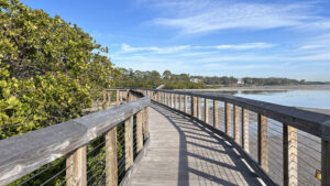
A gem along Upper Tampa Bay, Safety Harbor Waterfront Park has an outstanding boardwalk through a mangrove forest along an natural shoreline.
It glides along hidden mud flats where birds congregate and it provides expansive views of the bay.
 Bayfront boardwalk
A green ribbon along the waterfront downtown, this seven acre park also encompasses open grassy recreation spaces and the Veteran’s Memorial Park and Marina.
The broad paved path through the park is the east end of the Ream Wilson Trail, connecting a string of parks across Clearwater to Cliff Stephens Park near Moccasin Lake.
 A waterfront walk circles Veteran’s Memorial Park next to the marina
Resources





Disclosure: As authors and affiliates, we receive earnings when you buy through our links. This helps us provide public information on this website.
Overview
Location: Safety Harbor
Length: Up to 1.2 miles
Trailhead: 27.989126, -82.686245
Address: 105 Veteran’s Memorial Ln, Safety Harbor
Fees: Free
Restroom: At the trailhead
Land Manager: City of Safety Harbor
Phone: 727-724-1558
Open sunrise to sunset. Leashed dogs welcome; pick up after your pet.
Directions
Leaving the Courtney Campbell Causeway along SR 60 west from Tampa to Clearwater, turn right onto Bayshore Blvd and follow it north 2.4 miles to the park entrance on the right.
Hike
Begin with the concrete path closest to the shoreline of Tampa Bay, which reaches a circular plaza with picnic tables.
From it, visitors have a clear view of the bayfront and its tidal flats.
Near a unique sculpture, a globe expressing the diversity of humanity with hands, cabbage palms line the waterfront.
 Sculpture along the waterfront
Black mangroves have staked a fresh foothold along the flats at the end of a tiny beach. Chunks of limestone edge a protected wetland area.
Beyond a bench facing a swath of white sand beach, the boardwalk begins at 0.2 miles.
 Beginning of the boardwalk
Hovering above the bayfront vegetation at first, it sweeps past a pretty view of Upper Tampa Bay framed by red mangroves.
Turning towards the mangrove forest, it’s an expanse of leafy green.
 Upper Tampa Bay
Coming to a spur boardwalk, take it out to the bayfront, where it extends like a T over the tidal flats
An interpretive panel discusses what creatures live in the water. Gently rippled flats below are trammeled by the footprints of wading birds.
 Boardwalk observation deck
The bayside end of this boardwalk has an observation deck looking up along the waterfront you just walked, the ruins of the Safety Harbor pier standing out.
On the horizon, buildings in downtown Tampa rise in the hazy distance beyond a bridge on the Courtney Campbell Causeway.
 View towards downtown Tampa
Walk to the other end of the T for an observation deck facing the wooded shoreline of residential Safety Harbor.
Ibis ply shallows in coves which reflect the sky like a mirror. The far shore is Oldsmar, pylons of transmission lines radiating from the power plant.
 Mud flats near the shore
Returning to the main boardwalk, turn right. Zigzagging through the mangroves, reach a junction at 0.3 miles. Bear right.
Taller mangroves provide perches for birds scouting the bounty of this salty coastline.
 Heading along the waterfront to another view
A gentle curve leads to a panorama of the Safety Harbor coast and Upper Tampa Bay.
An interpretive panel discusses the shorebirds often seen here on the mud flats. Pockmarks in the tidal mud are the work of fish building nests.
 Overlooking the flats
Turn away from the open water on a straightaway lined by red mangroves, hovering above a cove of mud flats.
Return to a mangrove tunnel. At 0.4 miles there is a junction in the boardwalk. A boardwalk to the right burrows deeper into the mangrove forest.
 Low tide in the mangrove forest
It spans Mullet Creek to a walk-in entrance at the corner of North Bayshore Dr and Church St. Due to hurricane damage, it was closed on our visit.
When that route reopens, it extends this walk 0.2 miles by meeting the bike path. Return to Safety Harbor Waterfront Park via the bike path.
 Closed boardwalk
If it remains closed, take the boardwalk that isn’t. It descends from the mangrove forest as a gently sloping ramp.
Meet the bike path at a small plaza with a water station and bench and turn left. In either case, the water station is a landmark along your route.
 Water station at bike path
Follow the bike path along the forested rim of the park. Fronting a small rock garden, a marker recounts local history.
It explains the last known contact between the Spanish and the native Tocobaga. One of their tall temple mounds is preserved within nearby Philippe Park.
 Historic marker
Curving towards the open lawn facing the waterfront, the path reaches a junction with the boardwalk.
Making a left turn in front of a bench at a half mile, ascend another segment of the boardwalk.
 Bench at boardwalk junction
Walk between mangroves and peer down between them to see grassy flats and dark, rich mud.
The wading birds of the preserve are detailed at an interpretive stop. Jogging around a corner, meet the main boardwalk at a T at 0.6 mile.
 Among the mangroves
Turn right to return along the boardwalk past its observation spur and its sweep along the Tampa Bay waterfront.
When it ends in a tenth of a mile, follow the concrete walk back towards the parking area.
 Return to the path across the grassy lawn
Reaching the parking area, take a left past what remains of the pier. Stay with the path along the railing on the seawall, where a staircase leads down to the muck.
This walkway curves around the Veterans Memorial Marina Park, dominated by a large oak and several sheltered picnic tables.
 Seawall walkway
Expect to see many colorful pigeons resting, roosting, and strutting around in the shade.
According to a local who raised his own nearby as a boy, these feral pigeons are descendants of racing pigeons bred through the 1960s in the area.
 Veterans Memorial Park
Most feral pigeons seen in cities are the multi-generational offspring of domesticated birds, trained for message carrying and racing.
Like abandoned dogs and cats, pigeons instinctively crave human attention yet have been unfairly branded as pests.
 Treat pigeons kindly, they aren’t afraid of people
Views of the bayfront coastline continue until the seawall hooks around to the marina adjoining the park.
Return to the parking lot, completing this mile circuit, 1.2 miles if the boardwalk to Church Street has reopened.
 Parking area between the adjoining parks
Trail Map

Explore More!
Video
Hiking Safety Harbor Waterfront Park
Slideshow
See our photos from Safety Harbor Waterfront Park
Nearby Adventures
 Moccasin Lake Nature Park Savor a sliver of native habitats preserved in the heart of busy Clearwater under the cloak of a shady forest when you visit Moccasin Lake Nature Park and its environmental education center.
 Upper Tampa Bay Conservation Park A trio of trails explore bayfront habitats at this family-oriented park with a popular nature center and kayak launch on the north rim of Tampa Bay.
 Gladys E Douglas Preserve A series of short trails explore rare scrub communities within the last known rosemary bald habitat in Pinellas County.
 Hammock Park At Hammock Park, a well-marked trail network provides many options for exploring a 90-acre patchwork of diverse habitats adjoining the Pinellas Trail north of downtown Dunedin.

- Michael Crotty Bicentennial Park - November 3, 2026
- A.J. Henry Park - November 1, 2026
- Okeeheelee Nature Center Trails - October 22, 2026