

Ten linear miles north to south, Savannas Preserve State Park forms an immense buffer against the press of subdivisions to its west.
It protects of string of freshwater wetlands extending from Fort Pierce to Jensen Beach behind the Atlantic Coastal Ridge near the Indian River Lagoon.
 Water lilies in the prairie
The North End Trails explore the northermost portion of the preserve with a trail network made up of color-coded loops utilizing forest roads through pine savannas and prairies.
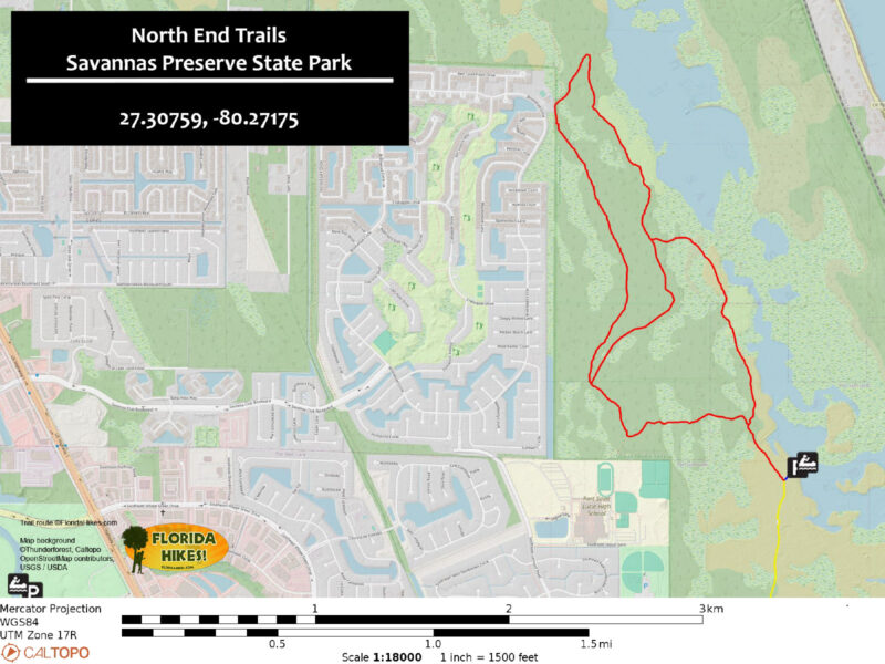
Except in an exceptionally dry season, expect some wading on this hike. Our 4.1 mile route follows the largest scenic loop in the trail system.
Extend it to 5.4 miles by starting at the Education Center parking area instead of the canoe launch, or up to 7.3 miles by adding in the Education Center Trails, too.
 Even an easy walk to the first boardwalk provides scenic views
Resources





Disclosure: As authors and affiliates, we receive earnings when you buy through our links. This helps us provide public information on this website.
Overview
Location: Port St. Lucie
Length: 4.1 miles
Trailhead: 27.307555 -80.271767
Address: 2541 SE Walton Rd, Port St. Lucie
Fees: $3 per vehicle
Restroom: At trailhead
Land manager: Florida State Parks
Phone: 772-398-2779
Open 8 AM to sunset. Leashed dogs welcome; pick up after your pet. Expect to wade; bring hiking sticks. Use sun protection, as shade is minimal. Mosquitoes can be fierce.
Adding to the challenge of this hike are ruts in the soft soil of the forest road network created by park vehicles, churning up mud in wetter spots.
Although the trails are open to off-road cyclists, there is at least one very challenging water crossing you’ll have to push your bike across.
A paved section of the East Coast Greenway under construction along the park’s perimeter will make access to the uplands beyond the sloughs easier.
Directions
From Interstate 95 exit 120 in Port St. Lucie, follow Crosstown Parkway east for 7 miles to US 1. Turn south. Drive half a mile and get in the left lane for the light at Walton Rd. Turn left and continue 1.9 mile to the Education Center trailhead. Turn left immediately inside the gate, pay your fee at the iron ranger, and continue 3/4 mile up the dirt road to the canoe launch parking area.
Hike
From the canoe launch parking area, walk back along its access road a tenth of a mile to the large North End Trails kiosk.
The map illustrates the network of color-coded trails; paper copies may be available to take with you. Enter at the pass-through next to the gate.
 North End Trails kiosk
Starting out as a grassy two-track road, the White Trail serves as the backbone of the trail network.
With the wetlands at the heart of the preserve to the east, the view in that direction is an open expanse of palmetto prairie with scattered slash pines.
 Marshy drainage at culvert
Cross a culvert draining a herbaceous marsh towards the vast wetlands. Deeply rutted by park vehicles, the two-track has mud holes to dodge.
Chalky bluestem grass dominates the spaces between the saw palmetto in this prairie, waving furiously in a seemingly ever-present breeze.
 Waving grasses
At 0.4 mile, a bench and signage mark the southern junction of the Yellow Trail. It is the most scenic of the North End Trails. Veer right to follow it.
It stays close to the edge of the pine savanna, providing excellent views to the east. Since it creeps close to the wetlands, the soil can be damp or flooded in places.
 Yellow Trail junction
A wide spot has been churned to mud by vehicles. Narrowing again, the grassy path breaks past a line of pines into an expansive prairie defined by orange-hued chalky bluestem.
Within these grasses wildflowers flourish, among them sabatia, candyroot, and pawpaw.
Reach the first of the Yellow Trail’s two boardwalks at 0.6 mile, a worthy destination for an easy round-trip.
 Approaching the boardwalk
With a bench built into the middle to let you settle in for birding, the broad boardwalk affords panoramas in both directions.
The vast open water wetlands define the eastern horizon, a galaxy of lilies floating atop them. A circular wet prairie sits to the west, the lilies extending across its open water as well.
 Wet prairie in the pine savanna
Immediately north of the boardwalk, the wet prairie drains across the Yellow Trail when it overflows.
A worn path edges it on the the left. That crossing may involve slogging through sticky mud or an ankle-deep wade.
 Higher ground in pine savanna
Rise into the pine savanna beyond it, where pink blossoms of sabatia attract attention. Work your way around a series of vehicle-induced mudholes in this pretty pine forest.
Views to the east encompass the enormity of the freshwater savannas. After a series of distinctly damp curves, meet the second boardwalk at a mile.
 Wet prairie view from boardwalk
This one curves inland, away from the big wetland and its marshy islands, towards the pine flatwoods. A bench is in its center.
Leaving the boardwalk, the Yellow Trail gains elevation through its slow curves into the flatwoods. Reach the upper junction with the White Trail at 1.2 miles.
 Upper trail junction
You can return to the trailhead from this point via the White Trail, but we expanded our loop by turning right, quickly immersing in the showy pine flatwoods.
Adjoining a perched marsh with tall grasses, the muddy tracks fill with water. The White Trail stays close to the wetlands, not as obvious due to the dense understory of saw palmetto.
 Expect more puddles and drainages
Keep an eye on the eastern horizon to catch occasional glimpses of a line of blue. Young longleaf pines flourish around one well-defined bend.
At a curve where pines tower overhead, the morning sun silhouettes a few cabbage palms.
 Curve in the trail
A sign and bench mark the northern junction of the Red Trail with the White Trail at 1.9 miles.
Although the North End Trails continue north (the White Trail leading to the Blue Trail and past it to a subdivision), we started our return to the trailhead here. Make a left.
 Trail junction
Edging the densely populated west side of the preserve, the Red Trail quickly meets the perimeter paved bike path along the west side of the park, with a neighborhood beyond.
The bike path was under construction on our visit, the surroundings torn up. Join it southbound over a bridge crossing a marsh.
 Bridge under construction during our visit
Beyond views of a retention pond in the neighboring subdivision, the red blazes veer left , leaving the paved path for a grassy two-track at 2.1 miles.
Entering a dense thicket of saw palmetto, the Red Trail curves, slowly retreating from the houses to the west.
 Pine flatwoods along the Red Trail
Immerse in a pine savanna, a grassy prairie defining the understory beneath scattered pines. Bog buttons rise from low spots. Candyroot thrives among the taller grasses.
In a drainage where water can collect in the trail, look for glistening red sundews and the yellow blossoms of bladderwort in the dark soil along its edges.
 Drainage area
The habitat shifts on the right to the thicket of saw palmetto, taller here, harder to see over. Colorful wildflowers edges the trail.
Reach a bench with a double red blaze on one side and a double white blaze on the other. At 2.9 miles, this is the southern junction of the Red Trail with the White Trail.
 Finishing up the Red Trail
Continue straight ahead into the grassy pine savanna, speckled with wildflowers in early spring.
Homes are visible again to the west as the trail draws close to the preserve boundary. A perched marsh drains into the grassy path and into deep ruts in the soft soil.
 Wildflowers under the pines
Curving east through the savanna, reach a bench at a trail junction. The White Trail turns left in front of this bench at 3.3 miles.
An unnamed path leads straight ahead towards the park’s perimeter adjoining Port St. Lucie High School, meeting the new paved bike path, a bailout for cyclists to avoid the slough.
 Bench at trail junction
Broadening, the path quickly emerges from the pine savanna into a large wet prairie. Regular visitors to this trail attest that it rarely dries out. Plunge into the sheet of water at your feet.
Portions of this crossing may be quite deep, knee level or higher. Use hiking sticks to keep your balance and to probe your route to avoid stepping into a mudhole.
 Start of the slough crossing
There may be a break of dry land for a breather on this soggy prairie traverse. The second crossing is deeper.
It is edged by a drainage where water flows towards the wetlands at the center of the preserve.
 Deep end of the slough
Reaching dry ground, enter the pine savanna, the forest road deeply rutted and muddy in low spots. A horizon line appears as the route shifts to face east.
Close the overall loop at the bench for the lower junction of the Yellow Trail at 3.7 miles.
 South junction with the Yellow Trail
Continue straight ahead along the white blazes for another quarter mile to exit at the gate and kiosk.
Turn left and walk the road to the canoe launch parking area, completing this 4.1 mile hike at the overlook.
Or, if you started from the Education Center parking area instead, turn right at the North End Trails kiosk instead of left and follow the white blazes back to it for a 5.4 mile overall hike.
 Return route to canoe launch parking area
Trail Map
Explore More!
Learn more about Savannas Preserve State Park
 Savannas Preserve State Park At Savannas Preserve State Park, a grand expanse of wet prairies and pine flatwoods extends across two counties to the west of the Indian River Lagoon.
Video
Hiking the North End Trails
Slideshow
See our photos from the North End Trails
Nearby Adventures
 East Coast Greenway Stuart Linking Port St. Lucie with Jensen Beach, Stuart, Port Salerno, and Hobe Sound, this 17.6 mile segment of the East Coast Greenway has dedicated bike paths at both ends.
 Savannas Hawks Bluff Trail Scramble up and down the Atlantic Coastal Ridge on this hike with scenic views of the southern end of the freshwater basin marshes stretching from Fort Pierce to Jensen Beach.
 Evans Creek Launch into a tributary of the North Fork of the St. Lucie River from state park land along US 1 in Port St. Lucie.
 Oxbow Eco-Center Preserve A network of nature trails circles natural habitats along North Fork of the St. Lucie River, radiating from an environmental center with family appeal.

- Hal Scott Yellow Trail - November 3, 2026
- Hal Scott Preserve - October 28, 2026
- Tradewinds Park - October 27, 2026