
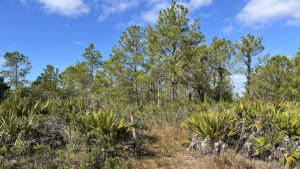
Across 1,700 acres of flatwoods and scrub surrounding a series of linear wetlands west of the Indian River Lagoon, see sandhill cranes and Florida scrub-jays along this pair of loop hikes.
Interstate 95 bisects the preserve. With two entrances, its East Tract lies between the interstate and US 1, easier to access and better for hiking.
 Hiking the Red Trail
The 6.5 mile Red Trail circles the entire East Tract, but spends a long stretch within earshot of the interstate in some seasonally soggy habitats.
Our 6.1 mile route cuts out a typically wet corner of the preserve by pairing a South Loop on the Red Trail using the White Trail as a crossover with the Blue Trail at the north end.
 The Red and Blue Trails share the northeast portion of the loop
Equestrians and hikers also have the option of the Yellow Trail, a separate 4.3 mile loop through the East Tract following old roads.
Given its remoteness from a trailhead, the West Tract is favored by equestians approaching via the grassy greenway adjoining the Brevard C2C bike path north of Aurantia Rd.
 Entry point to West Tract off Brevard C2C
Resources





Disclosure: As authors and affiliates, we receive earnings when you buy through our links. This helps us provide public information on this website.
Overview
Location: Scottsmoor
Length: Up to 6.1 miles
Trailhead: 28.764242,-80.881636
Address: 4055 Magoon Ave, Scottsmoor
Fees: Free
Restroom: At the trailhead
Land manager: Brevard County
Phone: 321-256-4466
Day use only. No pets. Portions of the trail system may flood. Use hiking stick to navigate stretches of extremely uneven, soft footing.
Mountain bikes are welcome, but both wetlands and hog damage churning up the trail present a serious challenge.
Equestrian use is limited to existing roads and trails posted for their use. None of the trailheads have space for horse trailers.
Directions
From Interstate 95 exit 231, Scottsmoor, follow CR 5A east a mile to US 1. Turn right. In 1.1 miles, turn right at the gas station onto Magoon Rd. Continue 0.3 miles west to where the road ends inside Parrish Park Scottsmoor. Hidden from direct view, trailhead kiosks lie north and south of the parking area in alignment with the ballfield fence.
Hike
From the parking area in Parrish Park, follow the worn path in front of the ballfield due south to the trail kiosk at a fence surrounding Scottsmoor Flatwoods Sanctuary.
Step through the gap and cross a broad grassy firebreak to a red and yellow-tipped post,the start of the clockwise loops of the Red and Yellow Trails.
 Trail kiosk at the north edge of Parrish Park
Pass a large live oak before the trail splits. Stick with the Red Trail, taking the right fork towards a line of pines.
Ascend into scrubby flatwoods, the understory an expanse of gallberry, shiny lyonia, and saw palmetto.
 Scrubby flatwoods
Amid palm fronds, drop through a drainage. Fluffy young longleaf pines grace a curve. Emerge at a broad firebreak with a red and white-tipped post on its far side.
The South Loop diverges behind the post at 0.2 mile. Bear left to stay on the Red Trail in a corridor defined by saw palmetto and young pines.
A small copse of scrubby oaks and a line of cabbage palms break up walls of gallberry.
 Start of the South Loop is just past the firebreak
Gleaming a viscous red in the sunshine, sundews poke through the grassy footpath. These tiny carnivorous plants thrive in slightly damp acidic soil.
Across from an opening to the paralleling Yellow Trail, glimpse one of the linear wet prairies to the west.
An ancient coastline defines this landscape, the wetlands trapped in swales between the north-south dune ridges.
 Wet prairie
Wind through the flatwoods understory, crossing the equestrian trail at a half mile. Gaining elevation, swing right past the next yellow post.
Enter a drier, more scrubby habitat. The lower understory affords panoramic views across a palmetto prairie.
 Palmetto prairie
Beyond an expanse of white sand road, walk amid prime scrub-jay habitat with myrtle and Chapman oaks.
Transition into pine flatwoods briefly before re-entering the palmetto prairie. Cross the white sand road a second time into a panoramic expanse.
A seasonal array of wildflowers delights, with the purple blooms of deer’s tongue a standout in fall and winter.
 Transition to flatwoods
As the density of pines increases, the habitat shifts to wet flatwoods. A grassy and obviously damp road bisects the trail at 1.1 miles and runs parallel to it briefly around a bend.
The understory is grassier, the saw palmetto more relaxed. Inspect the edges of the trail for more delicate blossoms.
 Curving through the southeast corner of the tract
Cross that same road twice more in the next quarter mile. Turning away from it, traverse a low ridge where a forest of oaks and pines is studded with cabbage palms.
Meeting the Yellow Trail, the Red Trail joins it at a sharp right. A showy expanse of wet prairie opens up ahead, a plank boardwalk bridging it at 1.5 miles.
 Boardwalk over wet prairie
Make a right at the red and yellow-tipped post, veering left soon after onto the broad path into an immersive pine flatwoods.
High and dry, this healthy habitat occupies much of the southern end of the preserve and is a delight to walk through. Songbirds flit through the branches.
 South end of the loop
As the trail turns west, the flatwoods become scrubby. We encountered a scrub-jay family a little before the turnoff to the south entrance to the preserve at 1.9 miles.
It’s a walk-in entrance from a neighborhood, out of view of a junction with two red-tipped posts. Turn right to stay on the loop.
 Walk-in trailhead
Aiming north, the Red Trail continues through lush pine flatwoods, crossing a prairie swale with St. Johns Wort. It’s the first spot past the boardwalk where you may need to wade.
Rise into a drier flatwoods where pond pines make their first appearance. These skinny pines are easily distinguised by needles growing out of their trunks.
 Prairie swale
Continue a gradual climb, and loblolly pines predominate over the saw palmetto lining the trail.
Hemmed in by palm fronds, the footpath narrows as it twists and winds. As the sound of the interstate increases, glimpse a prairie beyond the pines.
 Narrow corridor
Join the Yellow Trail at 2.3 miles to round a large marsh. Watch for the red-tipped post to veer off the equestrian trail into the pines.
The saw palmetto are taller and older along this corridor. Scattered cabbage palms and dahoon holly rise above them.
Despite the density of the understory, the mesic flatwoods are drenched with traffic noise on this side of the preserve.
 Along the marsh
A deep dip in the footpath among the saw palmetto may hold water. Intersect a grassy firebreak at 2.7 miles, interstate traffic visible to the west.
Cross the Yellow Trail a tenth of a mile later. More grassy openings punctuate the forest as the trail twists and winds.
Ascend into scrubby flatwoods before the next Yellow Trail crossing, returning to mesic flatwoods soon after.
 Yellow Trail crossing
A long straighaway yields to grassy curves where water collects often enough to nourish spagnum moss. While largely dry, these flatwoods have their low spots.
Meet the junction with the White Trail at 3.4 miles. Continue straight ahead, now following white-tipped posts. Gently rise over a ridge within a drier pine forest.
 Joining the White Trail
Merge into the Yellow Trail briefly in a grassy area, diverging to traverse a sometimes-wet grassy swale.
Continue along a broad two-track road amid the pines, watching for a blazed turnoff to the right at 3.6 miles.
 Grassy swale
Ascending another ridge between the central wet prairies, follow the gentle curves of the trail under the pines.
Reach the conclusion of the White Trail at 3.8 miles. Turn left onto the Red Trail, retracing its route back to Parrish Park to complete a 4.1 mile hike.
 Nearing the White/Red trail junction
Crossing the park to the parking area, continue straight ahead towards a gate. Just beyond it is the trailhead kiosk for the north end of Scottsmoor Flatwoods.
The Red and Yellow Trails start counterclockwise from here, as well as the Blue Loop. Turn left past the kiosk to start.
 Entry point for Blue Loop
Blazed with posts tipped red and blue, the corridor edged by palms and oaks yields to pine flatwoods. After 0.2 mile, turn right at a T junction.
The footpath is accented by a bounty of blooms each spring. Wild bachelor’s button grows in profusion; grass-pinks wave in the breeze.
 April is prime time for wildflowers
Cross a firebreak at 0.4 mile and continue along a line of pines into a palmetto prairie. Low-bush blueberries grow along the edges of the footpath, ripening in late April.
Within earshot of US 1, wind past a stand of pond pines on the eastern side of the the preserve.
These bushy-looking pines emerge from the surrounding sea of palmettos as the trail progresses.
 Blueberries ripening
At a mile, along the northern edge of the preserve, the Yellow Trail turns in from a firebreak and joins the Red and Blue Trail.
All three share an arc through the mesic flatwoods for a tenth of a mile to the next junction.
 Crossing the flatwoods
Turn left to continue on the Blue Trail, broad and carpeted in pine duff. At first, bracken fern obscures the forest floor, but as the trail descends, cinnamon fern edges the path.
Returning to mesic flatwoods, expect some dampness in the grassy path around 1.5 miles, where a wet prairie occupies a swale beyond the pines to the west.
 Prairie after a prescribed burn
Parallel this landform until the pathway turns east, quickly reaching a red and blue-tipped post to complete the Blue Loop.
Turn right to walk between the cabbage palms and pines to exit, reaching the trailhead after 1.9 miles on the Blue Loop, 6.1 miles for the full hike.
 Sealing the Blue Loop
Trail Map

Explore More!
Video
Hiking Scottsmoor Flatwoods Sanctuary
Slideshow
See our photos from Scottsmoor Flatwoods Sanctuary
Nearby Adventures
 Brevard Coast to Coast Trail The eastern terminus of the state-spanning Coast to Coast Trail is in the trail town of Titusville, where a ride on the Brevard Coast to Coast Trail provides cyclists the best ride in the county
 Seminole Rest The accessible Seminole Rest Trail interprets a historic and archaeological site at Canaveral National Seashore along the shores of the Indian River Lagoon.
 Salt Lake WMA Spanning nearly 8,000 acres between Salt Lake, Lake Loughman, and South Lake, Salt Lake WMA is a popular birding and fishing destination with many miles of trails.
 Buck Lake Conservation Area East Watch for flashes of blue as Florida scrub-jays flit between shrubs on scrubby islands along the eastern loops of 9,600-acre Buck Lake Conservation Area.

- Fort Matanzas National Monument - November 21, 2026
- Carney Island Conservation Area - November 19, 2026
- Hal Scott Red Trail - November 13, 2026