
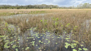
Protecting a sheet flow of rainfall moving steadily southward and parallel to the Atlantic Ocean, Grassy Waters Preserve bears a striking resemblance to the Florida Everglades.
It’s hard to imagine now, with the crush of humanity along this coast, but this shimmering sheet of sawgrass once was part of the River of Grass.
 The Grassy Waters
Bounded by development to the south, it’s a massive preserve – 23 square miles – part of a landscape that nourished what we now think of as our Everglades.
It exists, untouched, because it supplies drinking water for the residents of West Palm Beach and several other communities.
 Launch point into the preserve
Resources



Disclosure: As authors and affiliates, we receive earnings when you buy through our links. This helps us provide public information on this website.
Overview
Location: West Palm Beach
Trailhead: 26.808829, -80.169952
Address: 8264 Northlake Blvd, West Palm Beach
Fees: Free
Restroom: At the trailhead
Land Manager: City of West Palm Beach
Phone: 561-804-4980
Open Mon-Sat 8 AM-4:30, Sun 8:30 AM-5 PM. No dogs or bicycles. Insect repellent advised in the warmer months.
Directions
From Florida’s Turnpike, follow PGA Blvd 4.2 miles west to the Beeline (SR 710). Drive south 3.4 miles to Northlake Blvd (CR 709A). Continue 0.9 mile west to the park entrance on the left.
About the Preserve
Grassy Waters Preserve is far larger than you’d suspect. The Cypress Boardwalk at its main entrance has been a showpiece since it opened, but trails lie north and south, too.
North of Northlake Blvd, the Hog Hammock and Eagle Trails offer uplands and levees to traverse above the vast river of grass.
To the south, the Owahee and Apoxee Trails splash right into wild habitats edging West Palm Beach.
 Pathway through Hog Hammock
It’s the Cypress Boardwalk, however, that draws most visitors. Leading to and past the nature center, it’s an accessible immersion into these wet and wild habitats.
Extending through low-lying tree islands for a half mile, it has many benches as it connects launches for kayakers and multiple observation decks with panoramas of the grassy waters.
 The Cypress Boardwalk
Hike
Start at the prominent kiosk adjoining the long waterfront deck on a man-made channel within the wetlands. With railings on both sides, the broad boardwalk enters a cypress dome.
Thickets of hog plum, the shiny leaves of pond apple, and marsh ferns are part of a gradient of green.
They keep this swamp forest lush in winter when the cypress shed their needles in preparation for new spring growth.
 Trailhead kiosk
Across patches of open water, cypress knees jut from the forest’s reflections. Interpretive signs recount the human presence in this swamp.
Both ancient peoples and the Seminoles called these low islands in the Everglades home, the Seminole forced out by the U.S. Army in the 1860s.
 Crossing the cypress strand
At a split in the boardwalk, veer left to the Nature Center.
After a visit with its inhabitants, continue along the boardwalk in front of the cypress strand along the open expanse of the wet prairie.
Kayakers follow the slender channel cutting through the grassy waters. The boardwalk zigzags to a set of steps leading into the water.
 Looking towards the nature center from the observation deck
An observation deck looks across a lily-dotted pond in the swamp, with an interpretive sign calling attention to the distinct shape of cypress domes in the distance.
Re-entering the cypress strand, meet a junction with the other end of the loop through it. Turn left, descending to a lower boardwalk.
 Edge of the cypress strand
It has guiderail footers but no railings for an immersion in the tropical forest. It’s still quite wet below, with patches of solid ground indiscernible.
Many species obscure the soggy forest floor, like saw palmetto, myrsine, marlberry, and oaks.
 The low boardwalk
Short straightaways turn sharp corners so you can never see too far ahead. Go through a 90-degree turn at 0.2 miles.
A chickee platform hosts two rocking chairs looking out into the swamp. Occasional flagging here and at other locations along the boardwalk indicates a swamp walk route.
 Rocking chairs with a swamp view
Guides take school groups and visitors on a very soggy tromp through this wet forest between the boardwalks.
These walks include interpretation of the plant species you see along the way. Check the preserve’s schedule to sign up for one.
 Swamp walks go through this strand
A tunnel of trees briefly shades the boardwalk before its next sharp turn. Look carefully into the tannic pools at the bases of the cypress.
Tiny gambusia (mosquitofish) wriggle, and there are tiny purple flowers atop carnivorous bladderworts. Both consume mosquito larvae, natural insect control for the swamp.
 Bladderworts
Jog into a straightaway with larger pond apples along it and a slash pine. Heading towards a wall of cypress, take in the variety of ferns and bromeliads among the tree trunks.
Turn right for another stretch of straightaway, this one headed into a thicket of shrubs. The following jog reveals cabbage palms along the boardwalk and a junction at 0.3 miles.
 Trail junction
At a sign commemorating the commissioners responsible for the preserve, turn left. Walk out to a chickee at a beauty spot overlooking a cove of the grassy waters between cypress domes.
In the dark watery gaps between thick shocks of sawgrass, water lilies decorate the dark surface.
 Overlook
Return to the main boardwalk and turn left. Slip around corners through a drier island where slender slash pines rise above the riot of understory.
Two sharp bends lead to a final straightaway. Like the side trip, the boardwalk gains railings as it extends across the grassy waters.
 Prairie boardwalk
Leave the cypress strand for a panorama across an immense wet prairie, distant cypress strands bounding its edges. Traffic on a bridge along Northlake Blvd sets a compass direction.
As in all other openings along the boardwalk, lilies dot open water. The boardwalk splits in two, with a ramp leading up to the observation deck.
 Wet prairie
The lower portion meets a kayak launch/landing apparatus floating in the water. Stairs connect the two boardwalks at the chickee.
Spotting scopes let you look off to the far horizon. At a half mile, savor this perch at the end of the Cypress Boardwalk before the return trip.
 Kayak dock
On the return, take the alternate route at the T intersection at 0.8 mile by making a left. It’s simply a different take on the cypress dome, with its own rain shelter with rocking chairs.
Slightly longer than the route past the nature center, it skims the west side of the same cypress dome.
 Rocking chairs in the cypress dome
From this perspective, edge along the sawgrass-filled pond at the dome’s center while also taking in views of the prairie beyond the cypress.
Pass several benches on widened portions of the boardwalk before rejoining the entrance walkway at a T intersection. Turn left to exit, completing a mile hike by returning to the trailhead.
 Looping to the nature center
Trail Map

Explore More!
Discover the other hikes within Grassy Waters Preserve. Each has its own trailhead.
 Grassy Waters Hog Hammock Trail At the north end of Grassy Waters Preserve, traverse an Ice Age ridge protruding above the sheet flow of Loxahatchee Slough on a series of islands topped with tropical hammock.
 Grassy Waters Eagle Trail On a slender causeway between the marshes of Gator Lake and Loxahatchee Slough, the Eagle Trail balances immersion in a tropical hammock with scenic views.
 Apoxee Wilderness Trail In the wet prairies and tropical hammocks of Apoxee Wilderness, an urban wilderness area, tackle a 4.7-mile day hike through the southernmost part of Grassy Waters Preserve.
Video
Hiking the Cypress Boardwalk at Grassy Waters Preserve
Slideshow
See our photos from the Cypress Boardwalk
Nearby Adventures
 Loxahatchee Slough Natural Area Escape to a vast watery wilderness where you can hike, bike, or paddle through Northern Everglades habitats on the outskirts of residential Palm Beach County
 Sandhill Crane Access Park With an observation tower overlooking adjacent trails and an expanse of cypress swamp, Karen T. Marcus Sandhill Crane Access Park provides a gateway to adventure.
 Hungryland Boardwalk A short walk from the Ocean to Lake Hiking Trail in J.W. Corbett Wildlife Management Area, a scenic boardwalk loops through cypress forests covered with native orchids and bromeliads.
 Winding Waters Natural Area Miles of marked trails wind through restored wetlands and pine forests teeming with birds on a large parcel of land saved from development after years of agricultural use.

- Baseline Trails - November 7, 2026
- Hal Scott Yellow Trail - November 3, 2026
- Hal Scott Preserve - October 28, 2026