
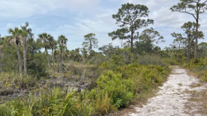
Protecting a significant remnant of longleaf pine flatwoods, this 71 acre preserve less than three miles from downtown Venice surprises.
Beyond its not-so-inspiring entrance along a boundary fence, wildflowers flourish among wiregrass.
 Longleaf pines and wiregrass dominate the uplands
Longleaf pines rise within sight of a mangrove-lined stream. Gopher tortoises are in residence; watch for their burrows in the sandhills.
Among the rare flora found here is endemic Florida milkweed. This is also one of the northernmost outposts for pond apple trees.
 Pawpaw blooming under the pines
Resources





Disclosure: As authors and affiliates, we receive earnings when you buy through our links. This helps us provide public information on this website.
Overview
Location: Venice
Length: 1.6 miles
Trailhead: 27.115447, -82.417472
Address: 1500 Pinebrook Rd, Venice
Fees: Free
Restroom: None
Land Manager: Sarasota County
Phone: 941-861-5000
Open 6 AM to sunset. No dogs. Cyclists welcome. Parking is limited.
Directions
From Interstate 75 exit 193, Jacaranda Blvd in Venice, drive north 0.6 miles to where the road ends at a T intersection. Turn left onto Border Rd. Continue 2 miles to Pinebrook Rd. Turn left. In a half mile, turn in on the right at what appears to be the entrance to a farm; a two track curves left in front of its gate to the small adjoining trailhead parking area, which has prominent signage.
Hike
After reviewing the map on the kiosk, follow the grassy road beyond it, paralleling the farm fence.
Skipping the path behind the first treeline, take the mowed trail that bears left off this straightaway at a Y junction into the pine flatwoods.
Like most forests close to this coast, it bears scars of the heavy winds of the 2024 hurricane season.
There were uprooted trees, snapped-off trunks, and diminished foliage in the upper branches of the oaks on our visit.
 Entrance kiosk
Curve through a sea of saw palmetto and bracken fern towards a line of cabbage palms.
Drop through a depression behind the palms, a channel that sometimes fills with water.
Because of that possibility, a secondary trail off the fenceline trail meets this footpath on the east side of the ditch.
 Palm-lined dip
At 0.2 mile, a third trail joins in from the fenceline trail at Marker 26, providing three ways to reach the bench facing a canal.
One of many dug in the heyday of draining Florida marshlands, it interfered with the natural flow of Curry Creek.
The homes on its opposite shore are largely obscured by forest.
 Canal
Continue in an easterly arc into the longleaf pine flatwoods, where majestic pines rise high above a textured understory.
In spring, the ivory blossoms of pawpaw draw attention. A line of wax myrtle and bay trees are a reminder that freshwater rises here, only a few miles from the Gulf.
 Wax myrtle and loblolly bay
Cabbage palms stake a claim to the edge of a wild section of the canal. A low depression in the grassy path marks another seasonal drainage before a slight ascent.
Meet the junction at Marker 18 at 0.4 mile. Turn left to stay on the perimeter loop.
 Marker 18 junction
Seasonal wildflowers peep from the wiregrass that dominates this corner of the flatwoods, including roserush, wild bachelor’s-button, and Florida milkweed.
Descending towards Curry Creek on a sandy curve, take in a view of the marsh below. A bench provides a perch for birding along this mingling of habitats.
 Descent to marsh
Walking along the winding waterway, climb into the sandhills, where low bush blueberry intermingles with newly spouted oaks.
Scrub oaks frame views of the creek. Wiregrass carpets the open patches of understory. Making a sharp right at Marker 25, parallel Curry Creek upstream.
 Paralleling the creek
A little over a half mile into the hike, make a left at Marker 21 and plunge through a tributary of the creek.
It may be mucky or a wade, depending on recent rains and the time of year.
 Connector at Marker 21
Climbing to the T intersection with the outermost loop in this chain of three, bear left.
Start a clockwise circuit of the most substantial stretch of healthy longleaf pine flatwoods in the preserve.
 Amid the pines
It’s an immersive walk amid a wildflower-dotted island of uplands bordering the creek, longleaf pines towering overhead.
A third of the way around the loop, winding waters are outlined by giant leather fern and young mangroves.
 Feeder streams create microclimates ideal for unusual plant species
Curving away from the creek basin, follow a straightaway which then sharply turns away from a gate.
That’s a future entry point to the expansion of the preserve. Established in 1923, the adjoining Edmonson Dairy is where the creek’s fresh water rises.
Briefly parallel a fence along a rural homestead before another immersion in longleaf pine savanna. Reaching the end of the loop, turn left to exit it.
 Back gate
Climb through the tributary basin, meeting Marker 21 again at a mile. Turn left to continue along the outer perimeter of the trail system.
While still among the pines, it is close to the preserve fence on this side of the loop, within view of neighboring farm buildings and homes.
Marker 20 sits next to a bench facing away from them towards the pines. Focus your attention into the flatwoods as the path grazes past a dog training facility.
 Bench at Marker 20
At 1.2 miles, Marker 19 adjoins the corner of the preserve fence and marks a decision point for the return trip to the trailhead.
It’s a quarter mile straight back to it if you stay next to the fence. Longleaf habitat adjoins the south side of the fenceline path
However, the north side looks into neighboring rural properties. So make a right at Marker 19 to walk through a beautiful stretch of longleaf for a tenth of a mile.
 Marker 19 junction
Returning to the familiar junction with Marker 18. Make a left to retrace your route into the preserve in much more natural surroundings.
Using any of the three paths curving north beyond the initial canal-facing bench at Marker 26 returns you to the trailhead for a 1.6 mile hike.
 Returning towards the Marker 26 bench
Trail Map

Explore More!
Video
Hiking Curry Creek Preserve East
Slideshow
See our photos from Curry Creek Preserve East
Nearby Adventures
 Sleeping Turtles Preserve North Named for a feature on old navigational maps, Sleeping Turtles Preserve North provides great views of the Myakka River from its bluffs.
 Carlton Reserve Less than a dozen miles from downtown Venice, the vast expanse of T. Mabry Carlton Reserve provides regional drinking water and a massive refuge for wildlife.
 Sleeping Turtles Preserve South Where subdivisions now occupy a formerly sleepy rural corner of Venice, Sleeping Turtles Preserve South provides a haven for wildlife along the Myakka River floodplain.
 Deer Creek Prairie Preserve Part of a complex of public lands protecting the Myakka River and its tributaries, Deer Creek Prairie Preserve blankets over 7,300 acres between Venice and North Port.

- Michael Crotty Bicentennial Park - November 3, 2026
- A.J. Henry Park - November 1, 2026
- Okeeheelee Nature Center Trails - October 22, 2026