
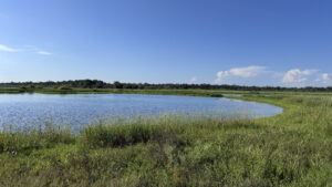
Known for its vast natural landscapes and abundant wildlife, Myakka River State Park provides a window to the past.
A mosaic of savannas and prairies once extended for countless miles across the southern end of the Florida Peninsula.
 Dry Prairie
Most folks visit the north end of the park, where a long road weaves through beautiful scenery and a popular nature trail leads to an impressive 74-foot tower high above the treetops.
Deep Hole, however, is a mystery. Only thirty permits are issued per day for hikers to trek to this ancient sinkhole south of SR 72.
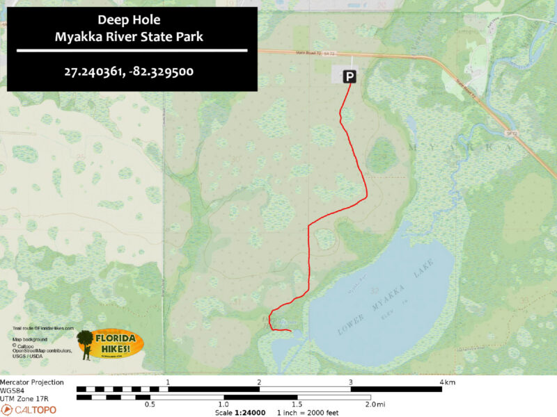
The round-trip immerses in wide open spaces, its finale a deep sinkhole in the Myakka River which massive alligators call home.
 The path to Deep Hole
Resources



Disclosure: As authors and affiliates, we receive earnings when you buy through our links. This helps us provide public information on this website.
Overview
Location: Sarasota
Length: 4.6 miles
Trailhead: 27.240361, -82.329500
Address: Lower Lake Ct, Sarasota
Fees: $6 per vehicle
Restrooms: None
Land manager: Florida Park Service
Phone: 941-361-6511
Open 8 AM to sunset. No pets or bicycles. Watch your surroundings carefully and do not get within twenty feet of an alligator.
A wilderness preserve permit must be obtained from the ranger station at the main park prior to entry. It’s best to arrive when it opens to obtain yours.
Directions
From the south (main) entrance gate for Myakka State Park on SR 72, head west on SR 72 for 0.8 mile, and look for a marked entrance on the left side of the road. Enter the gate code on the wilderness pass and continue down the dirt road for a tenth of a mile to a parking area at the end.
Hike
Starting at the parking area, use the walk-through next to a large metal gate and look for a sign indicating the direction of Deep Hole.
Follow the sandy access road as it leads through an oak hammock at the edge of an expansive prairie.
 Deep Hole trailhead
Entering the prairie, a verdant sea of grasses and shrubs stretches toward the horizon, dotted by a handful of pine and oak trees that cast welcome oases of shade on warm days.
The singsong calls of eastern meadowlarks fill the air as birds of prey soar high above the grassland.
 Dry prairie
After a couple of slight bends, turn southward towards a distinct tree line in the distance.
At 1.6 miles, the open prairie transitions to a hydric hammock community, where live oaks send their heavy, twisted branches overhead.
 Oak hammock
Near the floodplain, committees of vultures roost on the skeletons of old trees next to stands of tall cabbage palms rising above the canopy.
Reaching 2.2 miles, turn left to leave the road as it drops down into a grassy basin, following a worn trail at the edge of the woods.
 Roosting vultures
The glassy waters of the Myakka River come into view, sprinkled with distant white dots that could be herons, storks, or flocks of pelicans.
Continue eastward along the perimeter toward Deep Hole, being mindful of the presence of alligators.
 Myakka River
How close to approach the water will depend on where the gators are.
On a hot day they will likely be swimming above the sinkhole, and on a cold day, dozens of very large crocodilians will be lining the bank.
Be sure to give an abundance of space, then turn around from this point and retrace your footsteps for 2.3 miles back to the trailhead.
 Deep Hole
Trail Map
Explore More!
Learn more about Myakka River State Park
 Myakka River State Park With tall waving grasses, saw palmetto, and the sound of birds, Myakka River State Park is Florida's Big Sky country, blanketing more than 37,000 acres east of Sarasota.
Video
Hiking to Deep Hole
Nearby Adventures
 Myakka Hiking Trail For immersion in the vast central prairies of the Florida peninsula, the 39-mile Myakka Hiking Trail is a serious backpacking destination in South Florida near Sarasota.
 Myakka River Canopy Walk At Myakka River State Park in Sarasota, the Canopy Walk provides a sky-high view of the Myakka River basin as well as an intimate immersion in the live oak canopy in a beautiful hammock of oaks and palms.
 Carlton Reserve Less than a dozen miles from downtown Venice, the vast expanse of T. Mabry Carlton Reserve provides regional drinking water and a massive refuge for wildlife.
 Celery Fields A historic agricultural area transformed into a haven for birders, Celery Fields offers easy walking, running, and biking on paved and unpaved trails built around restored wetlands.

- Calusa Heritage Trail - November 5, 2026
- Scherer Thaxton Preserve - October 21, 2026
- Little Awesome Preserve - October 19, 2026