
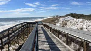
The coast of Walton County is home to rare coastal dune lakes, an ecosystem that only exists in Florida, Australia, and Africa.
You’ll find one of these fascinating lakes at Deer Lake State Park, west of Alys Beach along CR 30A.
 Deer Lake defines the western edge of the park
A delightful 0.3 mile linear boardwalk over the dune field leads to a sweeping view of the Gulf of Mexico and beach access.
Add a beach walk to see the outfall of Deer Lake, or explore the lesser known side of the park on a hike to the north end of the lake on the Deer Lake Trail.
 The upper end of Deer Lake
Resources




Disclosure: As authors and affiliates, we receive earnings when you buy through our links. This helps us provide public information on this website.
Overview
Location: Seagrove Beach
Length: Up to 3 miles
Trailhead: 30.302900, -86.074800
Address: 6350 E CR 30A, Seagrove Beach
Fees: $3 per vehicle in dropbox
Restroom: At the trailhead
Manager: Florida State Parks
Phone: 850-267-8300
Open 8 AM until sunset daily. Leashed pets welcome on footpaths but not on the boardwalk or the beach. A water bottle filling station is at the restrooms.
Directions
From US 98 at Rosemary Beach, follow CR 30A through Seacrest to Seagrove. The park entrance is on the left 2.7 miles past Watersound Pkwy. The entrance road splits inside the gate at the iron ranger. To include the boardwalk to the beach in your walk, use the main parking area at the end of this road. To hike only the Deer Lake Trail, turn around in that parking area and backtrack to one of the parallel parking spaces on the other side of the split entrance road.
Hike
The walkway guiding visitors to the beach starts from the main parking area to the right of the restrooms.
Stop at the water bottle filling station and top off, as the walk to the outflow of Deer Lake is entirely in the sun. Pass a kiosk with park information.
 Start of the accessible path to the beach
To cross the fragile coastal dunes, the walkway becomes a sturdy, broad boardwalk where the habitat transitions away from pine flatwoods. Railings are on both sides.
Once the boardwalk is above the dune field, there is a roofed observation deck with benches overlooking the upper end of the dunes closest to the pine flatwoods.
 Shaded bench
Deer Lake is the faintest of smudges to the west; the houses that rise beyond it are more recognizable.
Topped with a minimal amount of vegetation, the dunes are blindingly white in the sun.
 Boardwalk above the dunes
Past a pine on a ridge, the boardwalk extends high above a deep swale in the dunes, crossing it to the next crest of sand ridge.
From this height, you can see the Gulf of Mexico shimmering beyond the dunes.
 A blue horizon
The rounded shrubs thiving on the dunes below are Florida rosemary, the youngest evenly spaced.
That’s due to organic poison their roots put out to keep other vegetation from taking advantage of the shade they cast.
 Florida rosemary
Reach a second roofed observation deck with benches that overlooks the undulating landscape of the shifting dunes below.
Waves strum the shoreline where dunes meet beach, a panorama that opens up when the boardwalk turns to meet a staircase.
 Staircase to beach
The stairs provide the quick descent to the beach, but the boardwalk ramp to beach level is better for the views.
Continue to its west end, facing the the distant outfall of Deer Lake, where it exchanges its fresh waters with the Gulf.
 View to the west
It’s easy to discern the boundary of this park, as a massive build-up of residences and condos starts on the western shore of Deer Lake.
If you want to see the outfall up close, it’s a beach walk from the base of this boardwalk, an addition 0.7 mile round-trip.
 At the outfall
, witness how the tannic waters of Deer Lake flow into the Gulf of Mexico.
This happens when the lake is overfull. Waves wash into Deer Lake from the Gulf when the surf is up.
 The lake’s eroded channel speaks to strong releases of water after storms
In either case, the return trip to the parking area is exactly the way you came here, another 0.3 miles on the accessible boardwalk for either a 0.6 or 1.3 mile hike.
If you are adding a hike on the Deer Lake Trail to the boardwalk traverse, walk along the park road to the front entrance and cross CR 30A. It’s a half mile round-trip to its walk-in trailhead.
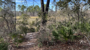 Deer Lake Trail Exploring one tiny corner of habitats preserved north of CR 30A, the Deer Lake Trail loops through sand pine scrub and offers views of the upper end of Deer Lake.
Alternatively, parallel parking spots just past a yellow-tipped post along the exit side of park road provide the closest parking to the Deer Lake Trail trailhead.
 Parking spots near the park gate
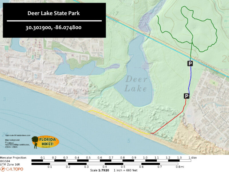
Trail Map
Explore More!
Slideshow
See our photos from Deer Lake State Park
Video
A walk through the Deer Lake Trail
Nearby Adventures
 Timpoochee Trail Showcasing the beauty of the South Walton coastline, the Timpoochee Trail connects coastal communities while leading cyclists past Florida's renowned Coastal Dune Lakes.
 Grayton Beach State Park Cradled in a cocoon of coastal dunes, Western Lake shimmers in the sun. At Grayton Beach State Park, it's the focus of both passive and active recreation.
 Camp Helen State Park Haunted by a sea monster sighted in one of the largest ancient coastal dune lakes on Florida's coast, Camp Helen State Park offers seaside relaxation and historic interpretation.
 Eastern Lake Trail A chain of three stacked loops that enable you to walk or ride up to 10.9 miles, the Eastern Lake Trail offers an immersion in Point Washington State Forest for hikers and cyclists.

- Fort Matanzas National Monument - November 21, 2026
- Carney Island Conservation Area - November 19, 2026
- Hal Scott Red Trail - November 13, 2026