
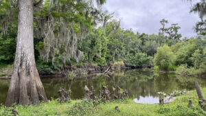
A decades-old city park on the east side of the Peace River, Fort Meade Recreation Area is the northern access point for two linear trails.
Paddlers put in here to follow the Peace River Trail 67 miles downriver to Arcadia. Cyclists and hikers can follow the Peace River Park Greenway, a graded 2.5 mile linear path.
 John starting a bike ride from the launch
Resources





Disclosure: As authors and affiliates, we receive earnings when you buy through our links. This helps us provide public information on this website.
Overview
Location: Fort Meade
Length: 1 mile loop
Trailhead: 27.747161, -81.779765
Address: 1639 Frostproof Hwy, Fort Meade
Fees: Free
Restroom: Near the large pavilion
Land Manager: City of Fort Meade
Phone: 863-285-1111
Open sunrise to sunset. Leashed dogs welcome.
Directions
From Lakeland, follow US 98 south through Bartow. Join US 17/98 and continue south for 11 miles to Fort Meade. Turn left onto US 98 and drive 1.5 miles. Immediately after the bridge, make a right into the park. While the upper part of the park has no defined parking areas, there is a picnic grove and trail marker. Unpaved lots are at the launch area and near the restrooms / large pavilion / playground. The mile walk described starts at the launch.
About the Park
Sprawling a good mile north-south but not very wide, this city park encompasses both the river floodplain and its uplands on the east shore.
On the opposite side of its eastern boundary fence are large water-filled phosphate mine pits. On its western edge is beautiful bottomland.
 Graded path through bottomland
Across from the turnoff to the launch, a newer playground sits atop the hill, a counterpoint to the 1960s-style play equipment still in use near the restrooms.
A large pavilion with a stage inside seems suited to special events and big gatherings. Old fashioned wayside park picnic tables adjoin the entrance road in clusters and individually.
 Central restrooms, playgrounds, and pavilion
The paved portion of the park road ends as a circle, but an unpaved road continues south to reach a large picnic area in a grove of older oaks.
A picnic pavilion and playground are at the north end. The graded greenway trail winds along the west side of the picnic grove.
 Greenway path in the picnic grove
The road to the launch drops into the floodplain and makes a circle near the boat ramp. Parking is in the grass and soil around it, which may be torn up, soft, or muddy.
A riverside kiosk is adjoined by an interpretative sign about the park’s connection to the Peace River watershed. Signage also calls your attention to the two trails leaving this point.
 Hand launch for the Peace River Trail
Hike
Beginning by the interpretive sign at the launch parking area, start your walk by slipping between the posts keeping vehicles off the broad riverside path.
Cypresses crown the river bluffs. Entering the forest, the graded path diverges from the river’s edge. The waterway remains within view as the trail mirrors its curves.
 Interpretive sign at the start of the hike
Cross a culvert draining the bottomland swamp into the river. A side path to the water’s edge is posted with a warning about alligators. They grow big along the Peace River, so keep alert.
Trees in the floodplain have fluted bases to hold their own during floods. Watermarks are two or three feet up their trunks, showing how high the river can rise.
 River view
Water lilies crowd a curve on the river within view of where the pathway straightens out and becomes more grassy.
Large mounds of what we think is Guinea grass, an import from Africa, flourishes throughout the understory, obscuring the forest floor.
 Scenic spot
Curving into the forest, the pathway is mottled with fossil shells. Just before the path leaves the river’s side, a leaf-strewn side path leads to a scenic bluff for a final panorama.
Enter a bottomland forest where the canopy of the trees glow in sunshine that doesn’t reach the forest floor.
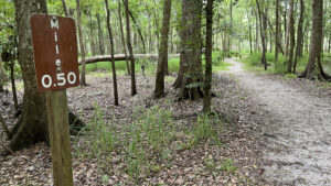
 A mile marker for the greenway
A wide wooden bridge crosses an ephemeral creek basin feeding the river. Bluestem palm crowds the understory under massive hardwoods.
Broader and sandier, the path aims for a bright patch of sunlight, emerging past a set of posts to pass under a power line.
 Floodplain bridge
At this dirt road junction, the Peace River Park Greenway continues its route south by turning right, running between the park road and the power line road.
 Peace River Park Greenway With river views near its ends, a graded 2.5 mile linear path in Fort Meade follows a slender strip of public land parallel to the east shore of the Peace River.
For the mile circuit of Fort Meade Recreation Area, turn left instead and walk up the road past the 15 mph speed limit sign.
 Picnic grove on hilltop
This corner of the park has a picnic pavilion, restrooms, and playground in the oak hammock adjoining the unpaved road. Continue along the roadside, uphill.
A line of tall grasses draws attention to the park boundary fence; beyond it are old phosphate pits. Some to the south of here have been converted into wetlands for water filtration.
 Following the unpaved park road
At the crest of the hill the paved portion of the park road circles a stand of planted palms.
Continue downhill, paralleling the paved road by walking along the mowed corridor on the edge of the floodplain forest.
 Walking towards the big pavilion
Picnic tables sit in pairs under the oaks. Cross the road to walk past the large pavilion and through the old-style playground with its merry-go-round and half-buried giant pipes.
Pass the restrooms. A newer, sleeker playground is at the top of the hill behind them. Just past the turnoff to the launch, cross the road by the wooden arch over it.
 Go through the arch to access the trail
At 0.8 mile, it’s the first place you can again access the graded pathway, the upper portion of the Peace River Greenway.
Follow it along the edge of the forest at the base of the picnic area to the mile 0.0 sign. Turn around, or continue to the path’s end at the park entrance to add another tenth of a mile.
 Greenway path through the picnic area
On the return trip, follow the path’s curve down into the river basin, paralleling the launch access road. Hugging closer to the forest as it descends, it immerses in floodplain habitat.
Cross the launch road at the pedestrian crossing sign. Roughed up in this area by vehicles, the path returns to the mile 0.25 sign, completing your mile circuit from the launch.
 Boat launch on the Peace River
Trail Map

Explore More!
Learn more about the Peace River
 Peace River Rising from marshes in the Green Swamp basin in Lakeland, the Peace River winds through fossil-rich Bone Valley west of the Lake Wales Ridge, reaching the Gulf of Mexico at Charlotte Harbor.
Video
A walk through Fort Meade Recreation Area
Slideshow
See our photos from Fort Meade Recreation Area
Nearby Adventures
 Peace River Hammock Walk softly through the immersive Peace River floodplain beneath enormous trees to a scenic bluff along the river where paddlers can come ashore.
 Paynes Creek Historic State Park Straddling the former treaty boundary of Seminole lands, this interpretive site along the Peace River features a network of trails tied together by a swinging footbridge.
 Hardee Lakes County Park A collection of former phosphate pits adjoining the floodplain of Paynes Creek provide anglers and campers with a destination west of the Peace River basin.
 Mosaic Peace River Park On the site of a former phosphate mine, worn footpaths top a windswept hilltop above the cypress swamps of the Peace River where a once-fabulous boardwalk to the river is in disrepair.

- Hal Scott Yellow Trail - November 3, 2026
- Hal Scott Preserve - October 28, 2026
- Tradewinds Park - October 27, 2026