
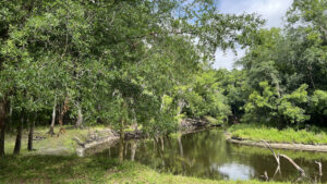
A patchwork of public lands edge the Peace River in three counties along the 67 mile paddling trail between Fort Meade Recreation Area and Arcadia
An integral piece of the north end of this paddling route, Peace River Hammock is part of the Polk County Natural Lands program.
 The preserve protects part of the river floodplain
Based on the narrow treadway, the trail is lightly used. It crosses both mine reclamation lands and the 42 acres along the river.
The difference between them is not obvious; the forest feels primeval. Keep alert for wildlife and keep track of your route in this surprisingly open and lush river bottom.
 The footpath is not always obvious
Resources





Disclosure: As authors and affiliates, we receive earnings when you buy through our links. This helps us provide public information on this website.
Overview
Location: Fort Meade
Length: 1.3 miles
Trailhead: 27.719280, -81.787183
Address: 2488 Mt. Pisgah Rd, Fort Meade
Fees: Free
Restroom: None
Land Manager: Polk County
Phone: 863-534-7377
Open 6 AM to 6:30 PM, hours expanded to 5:30 AM to 8 PM daylight savings time. No pets.
Use insect repellent to fend off mosquitoes and ticks. A map box next to the hike-in entrance may hold brochures for this hike.
Directions
From Lakeland, follow US 98 south through Bartow. Join US 17/98 and continue south for 11 miles to Fort Meade. Turn left onto US 98 and drive a half mile west. Make a right on S Orange Ave and continue 2.4 miles. En route, it changes names to Mt. Pisgah Rd and crosses the Peace River. Just beyond a trailhead on the left for the Peace River Greenway, a fence outlines the trailhead on the right for Peace River Hammock.
Hike
From the wooden pass-thru at the trailhead, follow the first of a series of brown arrow / hiker symbol markers down a corridor defined by oaks and needle palms.
Broadening, the leaf-strewn beaten path curves into the floodplain past the base of the first of many towering live oaks. Birdsong resounds through the dense forest canopy.
 Follow the arrows when you find them
Walk through a swale that may be damp at times. When the river tops its banks, the entirety of this forest is swamped.
Pay heed to any standing or flowing water. It should’t be here. If it is, you shouldn’t be.
 Leafy swale
The forest becomes denser, making the worn path particularly obvious. Vines dangle from the high canopy. Poison ivy may be growing on them or beneath the trees.
Dark green saw palmetto stand stiffly under moderate sized oaks. Walk beneath another grand giant with limbs furred by resurrection fern.
 Closing in on a very big oak
A trail marker confirms the still-obvious route, although the path narrows and curves, becoming a leafy track.
Another large oak has an unusual feature, a limb rising between the split in its substantial trunk. Grapevines spill across the grassy edge of the footpath.
 Unusual oak
The understory opens briefly where large limbs dipping towards the ground sprout gardens of goldfoot fern.
A massive oak dominates a small clearing where pennywort grows amid the leaf litter, signifying occasional immersion or, at the very least, dampness.
 A riot of green growth
Deep green colors seem richer in the deep shadows of the high canopy of this forest.
The path becomes less substantial, a mere trace in the leaves amid tufts of grass, but the corridor remains obvious.
 Forest grandeur
At a quarter mile, marvel at a behemoth of an oak with palm fronds obscuring its base.
Hickory and hophornbeam join the oaks in defining this hardwood forest, although the oaks stand out visually, especially when towering over the trail.
 Deadfall with grapevines
A transition occurs as more cabbage palms appear trailside. The path narrows more to scoot around a large deadfall swarmed by grapevines.
Beyond it, the understory opens again, rendering the path less distinct. Pay close attention to where the leafy track leads, confirmation being when it presses deeper into darkening soil.
 Wildflowers trailside
The trail corridor is less defined, but an oak limb making a complete arch just overhead calls attention to it up ahead.
Circle around a collection of blowdowns piled up on the left, following a faint two-track past another tipped-over tree, its roots akimbo.
 Tipped-over tree
Light shines through the forest ahead; the illuminated area is the river bluff. A brown arrow marker points you off the more obvious route and towards the bluff.
Aim for the picnic table beyond the trees. The trail ends in front of it at a grassy clearing atop the bluff.
 Picnic table on bluff
A nearby sign for Peace River Hammock faces the river. Downhill to the left, land meets water in a place where paddlers can drag their craft onto shore to take a break.
This is it! The destination. Now the trick is the return trip.
 Curve in the Peace River at the bluff
It’s crucial to find that last arrow that pointed you here to pick the correct route back to the trailhead, as blazing is non-existent and markers face the other way.
Use the landmarks and the landscape to find your way back. Reaching the trailhead, complete this 1.3 mile hike.
 Arched oak on the return
Trail Map

Explore More!
Learn more about the Peace River
 Peace River Rising from marshes in the Green Swamp basin in Lakeland, the Peace River winds through fossil-rich Bone Valley west of the Lake Wales Ridge, reaching the Gulf of Mexico at Charlotte Harbor.
Video
A walk through Peace River Hammock
Slideshow
See our photos from Peace River Hammock
Nearby Adventures
 Peace River Park Greenway With river views near its ends, a graded 2.5 mile linear path in Fort Meade follows a slender strip of public land parallel to the east shore of the Peace River.
 Fort Meade Recreation Area Anchoring two linear trails along the Peace River, this wayside park off US 98 in Fort Meade has been a destination for river access for decades.
 Paynes Creek Historic State Park Straddling the former treaty boundary of Seminole lands, this interpretive site along the Peace River features a network of trails tied together by a swinging footbridge.
 Hardee Lakes County Park A collection of former phosphate pits adjoining the floodplain of Paynes Creek provide anglers and campers with a destination west of the Peace River basin.

- Michael Crotty Bicentennial Park - November 3, 2026
- A.J. Henry Park - November 1, 2026
- Okeeheelee Nature Center Trails - October 22, 2026