
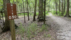
Spanning from mile 0.0 inside Fort Meade Recreation Area and ending at milepost 2.5 at Mt. Pisgah Rd south of Fort Meade, this linear greenway is somewhat of a secret.
On our way to visit Peace River Hammock we discovered a trailhead at the south end of this greenway signposted as “Peace River Park.”
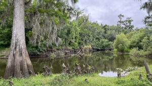
 A portion of the trail at Fort Meade Recreation Area parallels the Peace River
Since there is a Mosaic Peace River Park upriver and a far larger Peace River Park downriver in Wauchula, we decided to refer to this one as the Peace River Park Greenway.
Roughly paralleling the start of the Peace River Trail, a 67-mile paddling trail from Fort Meade to Arcadia, this graded path only stays close to river views near its two ends.
 Most of the central part of the trail edges treeline
Resources





Disclosure: As authors and affiliates, we receive earnings when you buy through our links. This helps us provide public information on this website.
Overview
Location: Fort Meade
Length: 2.5 miles linear
Trailhead: 27.750226, -81.777435 (mile 0) or 27.721772, -81.788931 (mile 2.5)
Address: 1639 Frostproof Hwy, Fort Meade
Fees: Free
Restroom: At Fort Meade Recreation Area
Land Manager: City of Fort Meade
Phone: 863-298-5200
Open 7 AM to 6 PM except during daylight savings time, when hours are extended to 6:30 AM to 8 PM. Leashed dogs welcome.
Directions
From Lakeland, follow US 98 south through Bartow. Join US 17/98 and continue south for 11 miles to Fort Meade. For the northern trailhead, turn left onto US 98 and drive 1.5 miles. Immediately after the bridge over the Peace River, make a right into the park. Pull off by the hiker sign. For the southern trailhead, return to US 98 and drive a mile west to S Orange. Turn left. It becomes Mt. Pisgah Rd. After 2.2 miles, the trailhead is on the left just after the bridge over the Peace River.
Hike/Bike
Start your hike or ride by descending to trail level along the forested edge of the picnic area. Cyclists can use a pass-through to join the trail just inside the park entrance.
 Fort Meade Recreation Area Anchoring two linear trails along the Peace River, this wayside park off US 98 in Fort Meade has been a destination for river access for decades.
Oddly, the mile 0.0 sign is not where the trail actually begins but below where the hiker symbol sign is along the park entrance road.
 Mile 0.0
A ribbon of crushed gravel and shell along the edge of the floodplain forest, the trail curves gently beneath the trees.
As it nears the launch access road, the path makes a broad curve to parallel it, reaching a pedestrian crossing sign.
 Paralleling the road to the launch
Cross the road and pass the 0.25 mile sign along the edge of the launch parking area, where the path has been partly obliterated by vehicles running over it.
The Peace River Trail paddling route begins at the this launch. An interpretive sign discusses the Peace River watershed.
 Peace River Trail launch
Slip between the yellow posts within sight of river bluffs topped with ancient cypresses.
Starting out the width of a road where it adjoins the river, the path quickly narrows and diverges from it.
 Follow the path next to the launch
Curving gently into the floodplain forest, cross a culvert draining the floodplain swamp into the river, a sign soon after warning about alligators.
Locals told us the biggest ones are in the wetlands at the south end of this trail, but we’ve seen sizable ones all along the Peace River.
 Riverside view with warning
The trees in the floodplain are sizable, too, the largest having buttressed roots and towering well overhead to form a high canopy.
Take heed of the watermarks on the surrounding tree trunks. When the river floods, this entire trail is under water.
 Bottomland forest in floodplain
Views of the river continue through the trees on the bluff for a few hundred yards, the trail quite pleasant and deeply shaded.
Just before the path leaves the river’s side, a leaf-strewn side path leads to a scenic spot for a nice panorama.
 Final river view at the north end
Swinging away from the river and into the floodplain forest, enjoy the immersion in these dark woods.
Cross a wooden footbridge over a creek which dries up except for pools beneath large cypresses.
 Bridge over creek in floodplain
Broadening where the floodplain is busy with palm fronds, the trail emerges into bright light under a power line with a two-track running under it.
Cross it and curve right, sticking with the graveled path. The park road (now a dirt road) is on your left, and beneath the oaks are a picnic grove and soccer field.
 Confusing junction. Cross the perpendicular path shown.
A wooden bridge for the trail parallels the park road bridge. The two-track and greenway path merge at the mile 0.75 sign.
Leave the merged path to the right at the “Peace River Park” sign where the posts are across the trail, exiting Fort Meade Recreation Area.
 Exit point southbound
Leaving the power lines behind as well, the broad path becomes the central feature of a grassy greenway bordered by forests, entirely out in the sun.
Split-rail fences call attention to culverts under the path. At the halfway point of the trail, a bench is trailside at the 1.25 mile trail marker.
 Halfway point
The path hugs closer to treeline, the better to catch a little afternoon shade along this utilitarian corridor.
There is clearly a water management component to this greenway, as a wellfield with signposted wells parallels the path.
 Passing Well #3
The tree canopy extends over the trail briefly before the mile 2.00 marker, when the character of the surroundings change.
“No Trespassing” signs flank a gate to the west, the entrance to city-owned wastewater treatment wetlands that locals say are home to enormous alligators.
 Forest tunnel past the wetlands junction
The forest now closes in on both sides of the pathway. A bench takes advantage of the shade cast by an archway of oak limbs over the trail.
Not far after the 2.25 mile marker, the trail splits. Downhill to the right leads to the Peace River one final time, a launch point along a waterfront defined by bridges.
 Parked by the launch under the Mt. Pisgah Bridge
Mt. Pisgah Road crosses the river, with the pillars of an old bridge adjacent. Steel beams sunk in concrete piers hold up a railroad trestle above the willow-lined tannic river.
After a visit to the river, follow the trail uphill in the opposite direction, passing another “No Trespassing” warning at a wetlands gate.
 Old bridges
Emerge at the southern trailhead for the Peace River Greenway, the 2.50 mile marker next to the parking area noting trail’s end.
If you don’t have a vehicle staged here for a linear walk or ride, turn around and head back along the same route.
 South end of the trail
Trail Map

Explore More!
Learn more about the Peace River
 Peace River Rising from marshes in the Green Swamp basin in Lakeland, the Peace River winds through fossil-rich Bone Valley west of the Lake Wales Ridge, reaching the Gulf of Mexico at Charlotte Harbor.
Video
Following the Peace River Park Greenway
Slideshow
See our photos from the greenway
Nearby Adventures
 Peace River Hammock Walk softly through the immersive Peace River floodplain beneath enormous trees to a scenic bluff along the river where paddlers can come ashore.
 Paynes Creek Historic State Park Straddling the former treaty boundary of Seminole lands, this interpretive site along the Peace River features a network of trails tied together by a swinging footbridge.
 Hardee Lakes County Park A collection of former phosphate pits adjoining the floodplain of Paynes Creek provide anglers and campers with a destination west of the Peace River basin.
 Mosaic Peace River Park On the site of a former phosphate mine, worn footpaths top a windswept hilltop above the cypress swamps of the Peace River where a once-fabulous boardwalk to the river is in disrepair.

- Baseline Trails - November 7, 2026
- Hal Scott Yellow Trail - November 3, 2026
- Hal Scott Preserve - October 28, 2026