• Skip to main content
  • Skip to header right navigation
  • Skip to after header navigation
  • Skip to site footer
Florida Hikes logo

Florida Hikes

Hike Bike Paddle Camp Florida with authors Sandra Friend and John Keatley as your guides

  • Trails
  • Maps
  • Guidebooks
  • Hike
    • Scenic Hikes
    • Loop Trails
    • Dog-friendly Hikes
    • Hikes for Kids
    • National Parks in Florida
    • Florida State Parks
  • Bike
    • Major Bike Trails
    • Paved Bike Trails
    • Off Road Biking
    • Biking Articles
  • Paddle
    • Canoe & Kayak Rentals
    • Paddling Destinations
    • Paddling Articles
  • Camp
    • Cabin Rentals
    • Car Camping
    • Primitive Camping
  • Florida Trail
    • Plan your Hike
    • Best Scenic Hikes
    • Best Backpacking
    • Section Hiking
    • Thru-Hiking
    • Trail Updates
  • Travel
Red blaze in scrub forest

High Bluff Coastal Hiking Trail

Discover the beauty of the Forgotten Coast by hiking one or both loops of the High Bluff Coastal Hiking Trail through scrub and wetlands fronting US 98 in Tate’s Hell State Forest.

Carrabelle (29.809317, -84.729067)   8.7 miles   Tates Hell State Forest
540 shares

Named after a legend of a local who became lost in these foreboding woods, Tate’s Hell is one of Florida’s largest state forests.

It encompasses over 200,000 acres within sight of the salty waters of the Forgotten Coast, accessed via US 98.

Trail with red and blaze blazes in scrub Following the West Loop into the scrub


The High Bluff Coastal Hiking Trail parallels the waterfront through relict dunes topped with scrub plants like Florida rosemary and scrub mint.

It combines two loops with a trailhead at each end. Each of these well-blazed trails can be hiked separately or together as one long loop.

Florida rosemary Walking through a rosemary scrub


Resources

Resources for exploring the area
Florida Trail Hikes book cover The Florida Trail Guide book cover North Florida Panhandle Explorers Guide book cover Hikers Guide to the Sunshine State book cover Paddlers Guide Florida
 
Disclosure: As authors and affiliates, we receive earnings when you buy through our links. This helps us provide public information on this website.

Overview

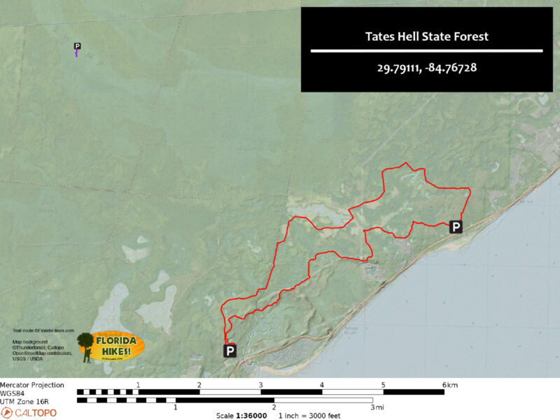
Location: Carrabelle
Length: 8.9 miles
Trailhead: 29.791111, -84.767278
Address: 2381 West US 98, Carrabelle
Fees: $2 per vehicle
Restrooms: None
Land manager: Florida Forest Service
Phone: 850-697-0010

Open sunrise to sunset. Leashed dogs welcome. Seasonal hunting occurs throughout this forest. Check ahead before you make plans for outdoor recreation.


Directions


From the intersection of US 98 and Tallahassee St. in downtown Carrabelle, head east on US 98. Continue on US 98, passing the East Trailhead on the right before continuing for another 3.3 miles to the West Trailhead and turning onto a dirt road. Follow the dirt road for 0.2 mile to a parking area at the end.

Hike

At the northeast end of the parking area, a covered kiosk provides paper maps and information about the forest.

Passing through a gap in a wooden fence marked with two orange blazes, follow the narrow trail leading through a shady stand of sand pines.

Kiosk and fence with gap into trail West trailhead


Shade doesn’t last long on the winding West Loop as the trail quickly opens to a scrubby flatwoods peppered with a mix of pines and an understory of dense brush.

Scrub oaks and lyonia border a corridor of bleached white sands alongside small clusters of false rosemary, lupine, and sand spikemoss.

Macro of scrub plants Unique scrub vegetation


Reaching 0.8 mile, the trail crosses a canal that passes though a salt marsh to the south before emptying into nearby Saint George Sound.

A picnic table sits on a sandy hill next to a metal pedestrian bridge spanning the brackish waterway.

Bridge behind picnic table Canal bridge


In a slow ascent of ancient sand dunes, large bunches of Florida rosemary become prevalent alongside the trail, filling the air with pungent aromas.

Deer moss and gopher apples carpet open areas between a variety of shrubs displaying an impressive palette of green hues.

Deer moss and rosemary Florida rosemary in the scrub


Continuing east, the trail dips into lower areas while crossing a mixture of basin swamps and mesic flatwoods.

A series of boardwalks cross wetland areas, although stretches of the trail may experience seasonal flooding based on recent rain patterns.

Wet footpath with bloom above Swamp titi in the wet flatwoods


At 2.8 miles, orange blazes end where the East Loop begins. A cross trail splits through the middle, separating the two loops.

Following blue blazes onward, traverse a rollercoaster of dry scrubby flatwoods and wetlands, passing a small side loop before reaching the East trailhead at the four mile mark.

Trailhead kiosk with address East trailhead


Directly to the east of the trailhead, blazes lead through a slough with potential for some of the deepest water on the trail.

This small section can be avoided by following a sandy forest road that curves to the northeast before meeting the trail again in a quarter mile.

Trail under water Trail through slough next to the East Trailhead


As the trail winds around to the north end of the East Loop, the path primarily follows wide, grassy access roads cutting through mesic flatwood habitats.

Several small boardwalks circumnavigate depressions in the road that are typically filled with water.

Bench atop an old boardwalk Boardwalk bench


Joining the West Loop again at 6.3 miles, orange blazes lead through patches historically used as pine farms.

Some are undergoing restoration efforts to return the ecosystem to a more natural state.

Following a sweeping curve at the western end of the loop, the trail encounters one final dip that may hold deep water.

Hikers can avoid this puddle by hopping over to an adjacent section near the beginning of the trail and following orange blazes for 0.2 mile to the trailhead.

Long forest road through pines Pine plantation under restoration


Trail Map

Tates Hell Trail Map
Red: High Bluff Coastal Trail. Purple: Kendrick Boardwalk.

Explore More!

Learn more about Tate’s Hell State Forest.

Tates Hell Swamp lilies Tates Hell State Forest One of Florida's more enormous state forests with over 202,000 acres, Tate's Hell is a vast coastal swamp sliced and diced by timber barons before being preserved by the state.

Video

A walk through the High Bluff Coastal Hiking Trail

Nearby Adventures

Ralph Kendrick Boardwalk Ralph G. Kendrick Dwarf Cypress Boardwalk Leading to a stand of dwarf bald cypress centuries old and less than 15 feet tall, the Kendrick Boardwalk at Tate's Hell State Forest is one of the weirder botanical spots in the Florida Panhandle.
Fort Gadsden Fort Gadsden At Fort Gadsden Historic Site, a gentle walk in the Apalachicola National Forest leads through the well-interpreted historic site and a pine forest where wildflowers thrive.
Florida Trail Jewel to Vilas Florida Trail, Jewel to Vilas 14.3 miles. Delving deep into the swampy heart of the Apalachicola National Forest, this section spans some of the gnarliest titi and gum swamps you'll see outside of Bradwell Bay.
Florida Trail at Cox Branch Florida Trail, Porter Lake to Jewel 4.6 miles. A deep immersion in pine flatwoods and titi swamps awaits along this segment of the Florida Trail, which uses many old forest roads to cross tributaries draining into the Ochlockonee River.

Trail Map (PDF) Hunt Dates Official Website

  • Author
  • Recent Posts
Chris Stevens
Chris Stevens
Along with his wife Chelsey, Chris Stevens shares outdoor adventures on Instagram and Facebook as @sunshinestateseekers and is a co-host of a podcast about Florida's outdoors, The Florida Madcaps. An avid hiker and camper, Chris serves as a Trailmaster and a board member for the Florida Trail Association.
Chris Stevens
Latest posts by Chris Stevens (see all)
  • McCarty Ranch Preserve - April 13, 2026
  • Bullfrog Creek WEA - April 7, 2026
  • Ney Landrum State Park - April 3, 2026
Category: Day Hikes, Hikes, Loop Hikes, Northwest Florida, TrailsTag: Apalachicola, Big Bend Scenic Byway, Birding, Botanical, Carrabelle, Eastpoint, Florida State Forests, Wildlife Viewing

Sidebar

FarOut Guides

Our comprehensive trail logistics presented on offline maps:

Florida National Scenic Trail (1,500 miles)
Florida Keys Overseas Heritage Trail (108 miles)
Eastern Continental Trail in Florida (92 miles)


We earn a small commission on sales through these links. Thanks for your support!


Our Guidebooks

We’ve written Florida guidebooks for over twenty years. These include Northwest Florida destinations.

Book cover of Florida Trail Hikes
The Florida Trail Guide fifth edition
Explorer's Guide North Florida & The Panhandle guidebook
Hiker's Guide to the Sunshine State

Explore More

Newest Articles for Northwest Florida

Sandy pathway through a bluff forest Maclay Gardens Ravine Trail
Floodplain in cypress swamp Ney Landrum State Park
Pathway through saw palmetto Fundy Bayou Loop
Clay path descending towards a kiosk Maclay Gardens Lake Trail

  • Facebook
  • Flickr
  • Instagram
  • Pinterest
  • Substack
  • Vimeo

FIND A TRAIL OR PARK

METROS: Bradenton. Clearwater. Crestview. Daytona Beach. Destin. Fort Lauderdale. Fort Myers. Fort Walton Beach. Gainesville. Jacksonville. Kissimmee. Lakeland. Melbourne. Miami. Naples. Ocala. Orlando. Panama City Beach. Pensacola. Port St. Lucie. Punta Gorda. St. Petersburg. Sanford. Sarasota. Sebring. Stuart. Tallahassee. Tampa. Vero Beach. West Palm Beach.

MULTI-REGION: Atlantic Coastal Ridge. Atlantic Coast. Bartram Trail. Big Bend. East Coast Greenway. Everglades National Park. Florida National Scenic Trail. Gulf Coast. Lake Wales Ridge. WATERWAYS: Indian River Lagoon. Intracoastal Waterway. Kissimmee River. St. Johns River. Withlacoochee River.

NORTHWEST FLORIDA: Altha. Apalachicola. Apalachicola National Forest. Big Bend Scenic Byway. Blackwater River State Forest. Blountstown. Bonifay. Bristol. Bruce. Cantonment. Cape San Blas. Carrabelle. Chattahoochee. Chipley. Crawfordville. DeFuniak Springs. Eastpoint. Ebro. Eglin Air Force Base. Freeport. Fountain. Gulf Breeze. Gulf Islands National Seashore. Holt. Madison. Marianna. Milton. Monticello. Mossy Head. Munson. Navarre. Navarre Beach. Newport. Niceville. Panacea. Panama City . Perdido Key. Ponce De Leon. Port St. Joe. Quincy. Santa Rosa Beach. Sopchoppy. South Walton. St. George Island. St. Marks. St. Marks NWR. Sumatra. Vernon. Wakulla. Wewahitchka. Woodville. WATERWAYS: Apalachicola River. Blackwater Bay. Blackwater River. Chipola River. Choctawhatchee Bay. Choctawhatchee River. Coastal Dune Lakes. Ochlockonee Bay. Perdido River. St. Marks River. Wacissa River. Wakulla River. Yellow River.

NORTH FLORIDA: Alachua. Amelia Island. Archer. Baldwin. Branford. Bronson. Bunnell. Callahan. Cedar Key. Chiefland. Crescent City. Cross City. Cross Creek. Dowling Park. Ellaville. Fanning Springs. Fernandina Beach. Flagler Beach. Fort White. Glen St. Mary. Green Cove Springs. Hawthorne. High Springs. Inglis. Jacksonville Beaches. Jacksonville Northshore. Jasper. Jennings. Keystone Heights. Lake Butler. Lake City. Live Oak.Macclenny. Mandarin. Mayo. Mayport. Micanopy. Middleburg. Old Town. Olustee. Orange Park. Osceola National Forest. Palatka. Palatka-Lake Butler Trail. Palm Coast. Palm Valley. Perry. Ponte Vedra. Rodman. Salt Springs. St. Augustine. Starke. Steinhatchee. Suwannee. Suwannee River Wilderness Trail. Suwannee Springs. Talbot Islands. Timucuan Preserve. Trenton. Waldo. Welaka. White Springs. Williston. Worthington Springs. Yankeetown. WATERWAYS: Santa Fe River. St. Marys River. Suwannee River. Tolomato River. Upper Withlacoochee River.

CENTRAL FLORIDA: Altamonte Springs. Apollo Beach. Apopka. Astatula. Astor. Auburndale. Bartow. Babson Park. Bayport. Belleview. Bithlo. Brandon. Brooksville. Bushnell. Canaveral National Seashore. Cassadaga. Christmas. Chuluota. Citrus Springs. Clearwater Beach. Clermont. Coast to Coast Trail. Cocoa. Cocoa Beach. Cross Florida Greenway. Crystal River. Dade City. De Leon Springs. DeBary. Deland. Deltona. Dunedin. Dunnellon. Edgewater. Enterprise. Eustis. Ferndale. Fort Meade. Frostproof. Geneva. Gibsonton. Haines City. Hernando. Hernando Beach. Holopaw. Homosassa. Inverness. Kenansville. Kissimmee. Lake Mary. Lake Wales. Largo. Leesburg. Lithia. Longwood. Lutz. Maitland. Malabar. McIntosh. Melbourne Beach. Merritt Island. Merritt Island NWR. Mims. Mount Dora. Narcoossee/Lake Nona. New Port Richey. New Smyrna Beach. Nobleton. Oak Hill. Oakland. Ocala National Forest. Ocklawaha. Ocoee. Oldsmar. Orange City. Ormond Beach. Osteen. Oviedo. Paisley. Palm Bay. Plant City. Poinciana. Polk City. Ponce Inlet. Port Orange. Ridge Manor. Riverview. Ruskin. Safety Harbor. Silver Springs. Sorrento. Spring Hill. St. Cloud. Tarpon Springs. Thonotosassa. Titusville . Umatilla. Viera. Walt Disney World. Weeki Wachee. Weirsdale. Wimauma. Windermere. Winter Garden. Winter Haven. Winter Park. Winter Springs. Withlacoochee State Forest. Withlacoochee State Trail. Yeehaw Junction. Zephyrhills. WATERWAYS: Alafia River. Halifax River. Hillsborough River. Lake Apopka. Little Manatee River. Ochlawaha River. Rainbow River. Tampa Bay. Wekiva River. Wekiva River Basin.

SOUTHWEST FLORIDA: Alva. Boca Grande. Cape Coral. Charlotte Harbor. Ding Darling NWR. Ellenton. Englewood. Estero. Immokalee. Marco Island. North Port. Osprey. Palma Sola. Palmetto. Pine Island. Port Charlotte. Sanibel Island. Venice. WATERWAYS: Caloosahatchee River. Manatee River. Myakka River. Pine Island Sound.

SOUTH FLORIDA: Arcadia. Basinger. Big Cypress National Preserve. Big Cypress Seminole Reservation. Big Cypress Swamp. Bowling Green. Clewiston. Everglades City. Indiantown. LaBelle. Lake Okeechobee Scenic Trail. Lake Placid. Lakeport. Moore Haven. Okeechobee. Ortona. Pahokee. Palmdale. Port Mayaca. South Bay. Wauchula. Zolfo Springs. WATERWAYS: Fisheating Creek. Lake Okeechobee. Peace River.

SOUTHEAST FLORIDA: Biscayne Bay. Biscayne National Park. Boca Raton. Boynton Beach. Coconut Creek. Coral Gables. Coral Springs. Davie. Delray Beach. Fellsmere. Flamingo. Fort Pierce. Hobe Sound. Hollywood. Homestead. Indrio. Jensen Beach. Juno Beach. Jupiter. Jupiter Farms. Key Biscayne. North Hutchison Island. Ocean to Lake Greenway. Palm Beach. Palm Beach Gardens. Pompano Beach. Redland. Sebastian. South Hutchinson Island. WATERWAYS: Florida Bay. St. Lucie River.

FLORIDA KEYS: Big Pine Key. Islamorada. Key Largo. Key West. Marathon. Overseas Heritage Trail.


©2006-2026, Sandra Friend & John Keatley | Disclosure | Site Index | Work with Us | Advertise with Us | Terms of Service and Privacy Policy

Florida Hikes PO Box 93 Mims FL 32754 | Contact