• Skip to main content
  • Skip to header right navigation
  • Skip to after header navigation
  • Skip to site footer
Florida Hikes logo

Florida Hikes

Hike Bike Paddle Camp Florida with authors Sandra Friend and John Keatley as your guides

  • Trails
  • Maps
  • Guidebooks
  • Hike
    • Scenic Hikes
    • Loop Trails
    • Dog-friendly Hikes
    • Hikes for Kids
    • National Parks in Florida
    • Florida State Parks
  • Bike
    • Major Bike Trails
    • Paved Bike Trails
    • Off Road Biking
    • Biking Articles
  • Paddle
    • Canoe & Kayak Rentals
    • Paddling Destinations
    • Paddling Articles
  • Camp
    • Cabin Rentals
    • Car Camping
    • Primitive Camping
  • Florida Trail
    • Plan your Hike
    • Best Scenic Hikes
    • Best Backpacking
    • Section Hiking
    • Thru-Hiking
    • Trail Updates
  • Travel
Path through pine forest

McCarty Ranch Preserve

Near the outskirts of Port St. Lucie, this city-run preserve presents a variety of opportunities for outdoor recreation, from camping and hiking, to fishing, kayaking, and disc golf.

Port St. Lucie (27.236194, -80.511667)   4.5 miles  

Within the western reaches of Port St Lucie as it stretches into rural landscapes bordering Lake Okeechobee, McCarty Ranch Preserve is a quiet nature retreat.

Serving the dual purpose of land conservation and water retention, a significant portion of the property contains large artificial lakes.

This open water and the surrounding pinelands are great for birding, catching a glimpse of an alligator, and watching the sun set a few steps away from a primitive campground.

Sunset reflected in water with grassy shallows Sunset on the reservoir


Resources

Resources for exploring the area
Hikers Guide to the Sunshine State book cover South Florida Explorers Guide book cover 50 Hikes in South Florida book cover Paddlers Guide Florida
 
Disclosure: As authors and affiliates, we receive earnings when you buy through our links. This helps us provide public information on this website.

Overview

Location: Port St. Lucie
Length: 4.5 miles in two loops
Trailhead: 27.236194, -80.511667
Address: 12525 Range Line Rd, Port St. Lucie
Fees: Free, Fee for camping
Restroom: Near trailhead
Land manager: City of Port St. Lucie
Phone: 772-871-1775

Open 8:00 AM to sunset. Leashed dogs welcome.


Directions


From Interstate 95 exit 114 at the south edge of Port St. Lucie, head west on SW Becker Rd for 4.4 miles. Turn right onto Range Line Rd. Make a left in 1.3 miles, where a sign indicates the entrance to the preserve. Follow this road for 1.9 miles to a parking lot next to the restrooms and trailhead.

About the Park

In the flatlands between the Orlando and Green Ridges east of Lake Okeechobee, there was once an expanse of wetlands known as the Al-Pat-ti-o-kee Swamp.

In the mid 1900s, canals were dug to drain the land for agriculture use. The area is now commonly referred to as Allapattah Flats.

Pine flatwoods Islands of pine flatwoods dot the Allapattah Flats


Over time, these canals caused issues with water quality in the St. Lucie River and the Indian River Lagoon.

In 2012, the City of St. Lucie purchased over 3,100 acres of Allapattah Flats for water storage.

Former mines on the property were repurposed as reservoirs and to prevent agriculturally polluted water from entering the river.

Large lake Lake John


While the water retention project is an ongoing endeavor, the secondary purpose of the property is to provide an outdoor recreation destination.

On the eastern side of the preserve, a short set of hiking trails explore existing pine flatwoods habitat. The city plans to expand this trail network to several miles.

Footpath in piney woods Gopher Tortoise Trail


A system of dirt roads encircling the lakes serves as a multi-use trail nearly 3 miles long, with spur loops designated for off-road biking and equestrian use.

The road can be driven on as well, although it is very rough in spots and best suited for four-wheel drive vehicles.

Gravel road along reservoir Multi-use loop trail


At the northern end of the loop, an 18-hole disc golf course offers a challenging round of golf with water hazards.

Although there is no dedicated launch, canoes, kayaks, and small boats with electric motors are welcome on the two southernmost lakes.

The lakes are also popular for fishing.

Disc Golf sign Disc golf course


Hiking

Two hiking trails traverse pine flatwoods, passing prairie lakes at the southern end of the preserve.

One trailhead is at the front parking area, and another next to the tent campground.

Trailhead signage next to footpath Trailhead near the entrance


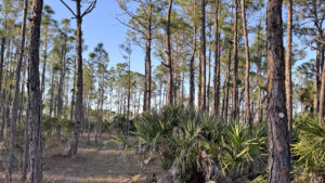
The Gopher Tortoise Trail is a well-marked, 0.8 mile linear route winding through pine forest, passing a scenic prairie pond along the way.

The trail can be turned into a 1.5 mile loop by using a portion of the multi-use lake trail and the road to the campground.

Yellow trail markers on pine trunk along trail in pine forest Pine flatwoods


At a tenth of a mile, the Palmetto Trail serves as a connector to the Gopher Trail, in close proximity to tent camping.

Starting and ending at the campground results in a one-mile loop with a glimpse of the marshy pond.

Marshy edged pond surrounded by pines Prairie pond


Camping

The park has two separate campgrounds, one designated for tent only, and another alongside the lake for RV use.

The primitive tent campground offers 13 sites with picnic tables and fire rings comfortably nestled in a pine forest near the entrance.

No water or electric are provided, but a bathhouse with hot showers is a little over tenth of a mile away.

Portable restrooms are located within the campground.

Vehicles are allowed at the campsites for loading or unloading only, with designated overnight parking located at the entrance near the bathhouse.

Picnic table and fire ring on edge of grassy clearing in pines Campsite 1


The RV campground has six primitive spots (no hookups) alongside the multi-use trail.

Overlooking the lake, each is roughly 40’ long and includes a picnic table and fire ring.

Sunshine illuminating a park bench and trash can with clearing between them and pines RV campground


Trail Map

McCarty Ranch Preserve Trail Map
Red: Gopher Trail Loop. Brown: Multiuse Trail Loop.

Explore More!

Video

Exploring McCarty Ranch Preserve


Nearby Adventures

Narrow path between tree trunks Bluefield Ranch Preserve Atop an ancient ridge between Lake Okeechobee and the Atlantic Ocean, Bluefield Ranch Preserve hosts a surprising diversity of habitats.
Pink blossoms of lyonia in pine flatwoods Hawks Hammock Preserve Miles of multi-use trails wander across an expanse of South Florida pine flatwoods wedged between the Green Ridge and Interstate 95 west of Stuart.
Path through tall grass between pines DuPuis WMA Explore nearly 22,000 acres of public land near Lake Okeechobee on extensive networks of trails for hikers, cyclists, and equestrians.
Florida Trail, Port Mayaca to Henry Creek Florida Trail, Port Mayaca to Henry Creek 14 miles. In an arc between ancient natural shoreline and expansive waters, this hike along Lake Okeechobee's eastern shore offers unparalleled vistas.

Trail Map (PDF) Official Website

  • Author
  • Recent Posts
Chris Stevens
Chris Stevens
Along with his wife Chelsey, Chris Stevens shares outdoor adventures on Instagram and Facebook as @sunshinestateseekers and is a co-host of a podcast about Florida's outdoors, The Florida Madcaps. An avid hiker and camper, Chris serves as a Trailmaster and a board member for the Florida Trail Association.
Chris Stevens
Latest posts by Chris Stevens (see all)
  • Kelly Park - November 18, 2026
  • Wekiwa Springs Hiking Trail - November 17, 2026
  • Black Lake Preserve - November 15, 2026
Category: Biking, Camping, City Parks, Day Hikes, Equestrian, Hikes, Loop Hikes, Nature Trails, Off Road Biking, Parks, Southeast Florida, TrailsTag: Birding, Fishing, Palm City, Picnic, Port St. Lucie, Primitive Camping, Wildlife Viewing

Sidebar

FarOut Guides

Our comprehensive trail logistics presented on offline maps:

Florida National Scenic Trail (1,500 miles)
Florida Keys Overseas Heritage Trail (108 miles)
Eastern Continental Trail in Florida (92 miles)


We earn a small commission on sales through these links. Thanks for your support!


Our Guidebooks

We’ve written Florida guidebooks for over 25 years. These include Southeast Florida destinations.

Book cover with woman hiking through palms with baby carrier
Book cover of Florida Trail Hikes
The Florida Trail Guide fifth edition

Explore More

Newest Articles for Southeast Florida

Emerging from a tunnel of trees to a waterfront Tradewinds Park
Bench at a junction of trails in pine-palm flatwoods Okeeheelee Nature Center Trails
Dense understory beneath pines along footpath Lakewood Regional Park
Silvery-blue saw palmetto Lantana Scrub Natural Area

  • Facebook
  • Flickr
  • Instagram
  • Pinterest
  • Substack
  • Vimeo

FIND A TRAIL OR PARK

METROS: Bradenton. Clearwater. Crestview. Daytona Beach. Destin. Fort Lauderdale. Fort Myers. Fort Walton Beach. Gainesville. Jacksonville. Kissimmee. Lakeland. Melbourne. Miami. Naples. Ocala. Orlando. Panama City Beach. Pensacola. Port St. Lucie. Punta Gorda. St. Petersburg. Sanford. Sarasota. Sebring. Stuart. Tallahassee. Tampa. Vero Beach. West Palm Beach.

MULTI-REGION: Atlantic Coastal Ridge. Atlantic Coast. Bartram Trail. Big Bend. East Coast Greenway. Everglades National Park. Florida National Scenic Trail. Gulf Coast. Lake Wales Ridge. WATERWAYS: Indian River Lagoon. Intracoastal Waterway. Kissimmee River. St. Johns River. Withlacoochee River.

NORTHWEST FLORIDA: Altha. Apalachicola. Apalachicola National Forest. Big Bend Scenic Byway. Blackwater River State Forest. Blountstown. Bonifay. Bristol. Bruce. Cantonment. Cape San Blas. Carrabelle. Chattahoochee. Chipley. Crawfordville. DeFuniak Springs. Eastpoint. Ebro. Eglin Air Force Base. Freeport. Fountain. Gulf Breeze. Gulf Islands National Seashore. Holt. Madison. Marianna. Milton. Monticello. Mossy Head. Munson. Navarre. Navarre Beach. Newport. Niceville. Panacea. Panama City . Perdido Key. Ponce De Leon. Port St. Joe. Quincy. Santa Rosa Beach. Sopchoppy. South Walton. St. George Island. St. Marks. St. Marks NWR. Sumatra. Vernon. Wakulla. Wewahitchka. Woodville. WATERWAYS: Apalachicola River. Blackwater Bay. Blackwater River. Chipola River. Choctawhatchee Bay. Choctawhatchee River. Coastal Dune Lakes. Ochlockonee Bay. Perdido River. St. Marks River. Wacissa River. Wakulla River. Yellow River.

NORTH FLORIDA: Alachua. Amelia Island. Archer. Baldwin. Branford. Bronson. Bunnell. Callahan. Cedar Key. Chiefland. Crescent City. Cross City. Cross Creek. Dowling Park. Ellaville. Fanning Springs. Fernandina Beach. Flagler Beach. Fort White. Glen St. Mary. Green Cove Springs. Hawthorne. High Springs. Inglis. Jacksonville Beaches. Jacksonville Northshore. Jasper. Jennings. Keystone Heights. Lake Butler. Lake City. Live Oak.Macclenny. Mandarin. Mayo. Mayport. Micanopy. Middleburg. Old Town. Olustee. Orange Park. Osceola National Forest. Palatka. Palatka-Lake Butler Trail. Palm Coast. Palm Valley. Perry. Ponte Vedra. Rodman. Salt Springs. St. Augustine. Starke. Steinhatchee. Suwannee. Suwannee River Wilderness Trail. Suwannee Springs. Talbot Islands. Timucuan Preserve. Trenton. Waldo. Welaka. White Springs. Williston. Worthington Springs. Yankeetown. WATERWAYS: Santa Fe River. St. Marys River. Suwannee River. Tolomato River. Upper Withlacoochee River.

CENTRAL FLORIDA: Altamonte Springs. Apollo Beach. Apopka. Astatula. Astor. Auburndale. Bartow. Babson Park. Bayport. Belleview. Bithlo. Brandon. Brooksville. Bushnell. Canaveral National Seashore. Cassadaga. Christmas. Chuluota. Citrus Springs. Clearwater Beach. Clermont. Coast to Coast Trail. Cocoa. Cocoa Beach. Cross Florida Greenway. Crystal River. Dade City. De Leon Springs. DeBary. Deland. Deltona. Dunedin. Dunnellon. Edgewater. Enterprise. Eustis. Ferndale. Fort Meade. Frostproof. Geneva. Gibsonton. Haines City. Hernando. Hernando Beach. Holopaw. Homosassa. Inverness. Kenansville. Kissimmee. Lake Mary. Lake Wales. Largo. Leesburg. Lithia. Longwood. Lutz. Maitland. Malabar. McIntosh. Melbourne Beach. Merritt Island. Merritt Island NWR. Mims. Mount Dora. Narcoossee/Lake Nona. New Port Richey. New Smyrna Beach. Nobleton. Oak Hill. Oakland. Ocala National Forest. Ocklawaha. Ocoee. Oldsmar. Orange City. Ormond Beach. Osteen. Oviedo. Paisley. Palm Bay. Plant City. Poinciana. Polk City. Ponce Inlet. Port Orange. Ridge Manor. Riverview. Ruskin. Safety Harbor. Silver Springs. Sorrento. Spring Hill. St. Cloud. Tarpon Springs. Thonotosassa. Titusville . Umatilla. Viera. Walt Disney World. Weeki Wachee. Weirsdale. Wimauma. Windermere. Winter Garden. Winter Haven. Winter Park. Winter Springs. Withlacoochee State Forest. Withlacoochee State Trail. Yeehaw Junction. Zephyrhills. WATERWAYS: Alafia River. Halifax River. Hillsborough River. Lake Apopka. Little Manatee River. Ochlawaha River. Rainbow River. Tampa Bay. Wekiva River. Wekiva River Basin.

SOUTHWEST FLORIDA: Alva. Boca Grande. Cape Coral. Charlotte Harbor. Ding Darling NWR. Ellenton. Englewood. Estero. Immokalee. Marco Island. North Port. Osprey. Palma Sola. Palmetto. Pine Island. Port Charlotte. Sanibel Island. Venice. WATERWAYS: Caloosahatchee River. Manatee River. Myakka River. Pine Island Sound.

SOUTH FLORIDA: Arcadia. Basinger. Big Cypress National Preserve. Big Cypress Seminole Reservation. Big Cypress Swamp. Bowling Green. Clewiston. Everglades City. Indiantown. LaBelle. Lake Okeechobee Scenic Trail. Lake Placid. Lakeport. Moore Haven. Okeechobee. Ortona. Pahokee. Palmdale. Port Mayaca. South Bay. Wauchula. Zolfo Springs. WATERWAYS: Fisheating Creek. Lake Okeechobee. Peace River.

SOUTHEAST FLORIDA: Biscayne Bay. Biscayne National Park. Boca Raton. Boynton Beach. Coconut Creek. Coral Gables. Coral Springs. Davie. Delray Beach. Fellsmere. Flamingo. Fort Pierce. Hobe Sound. Hollywood. Homestead. Indrio. Jensen Beach. Juno Beach. Jupiter. Jupiter Farms. Key Biscayne. North Hutchison Island. Ocean to Lake Greenway. Palm Beach. Palm Beach Gardens. Pompano Beach. Redland. Sebastian. South Hutchinson Island. WATERWAYS: Florida Bay. St. Lucie River.

FLORIDA KEYS: Big Pine Key. Islamorada. Key Largo. Key West. Marathon. Overseas Heritage Trail.


©2006-2026, Sandra Friend & John Keatley | Disclosure | Site Index | Work with Us | Advertise with Us | Terms of Service and Privacy Policy

Florida Hikes PO Box 93 Mims FL 32754 | Contact
