• Skip to main content
  • Skip to header right navigation
  • Skip to after header navigation
  • Skip to site footer
Florida Hikes logo

Florida Hikes

Hike Bike Paddle Camp Florida with authors Sandra Friend and John Keatley as your guides

  • Trails
  • Maps
  • Guidebooks
  • Hike
    • Scenic Hikes
    • Loop Trails
    • Dog-friendly Hikes
    • Hikes for Kids
    • National Parks in Florida
    • Florida State Parks
  • Bike
    • Major Bike Trails
    • Paved Bike Trails
    • Off Road Biking
    • Biking Articles
  • Paddle
    • Canoe & Kayak Rentals
    • Paddling Destinations
    • Paddling Articles
  • Camp
    • Cabin Rentals
    • Car Camping
    • Primitive Camping
  • Florida Trail
    • Plan your Hike
    • Best Scenic Hikes
    • Best Backpacking
    • Section Hiking
    • Thru-Hiking
    • Trail Updates
  • Travel
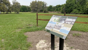
Interpretive sign along edge of pasture

Historic Ethel Trail

Inside Rock Springs Run State Reserve, an interpretive loop trail leads visitors through a corner of the state park where the rural settlement of Ethel once stood.

Sorrento (28.797972, -81.438750)   1.4 miles   Rock Springs Run State Reserve

A cemetery is the only visible evidence today of Ethel, a town that existed over a century ago between Mount Dora and Sanford.

Home to many families, the settlement had a train station, post office, general store, and school.

Entrance to cemetery Ethel Cemetery


Homesteaders first came to work the land. A freeze in 1895 ruined young citrus crops, causing many to abandon their properties. By 1920, only ten homes remained.

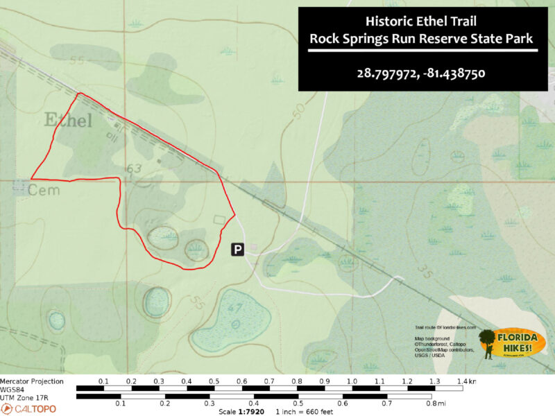
Beginning near the equestrian camp in Rock Springs Run State Reserve, a well-marked loop with more than a dozen interpretive stops display photos and information about the town.

Picnic tables under oaks Picnic area at the trailhead


Resources

Resources for exploring the area
Florida Trail Hikes book cover The Florida Trail Guide book cover 50 Hikes in Central Florida Central Florida Orlando Explorers Guide book cover 5 Star Trails Orlando Hikers Guide to the Sunshine State book cover Paddlers Guide Florida
 
Disclosure: As authors and affiliates, we receive earnings when you buy through our links. This helps us provide public information on this website.

Overview

Location: Sorrento
Length: 1.4 miles
Trailhead: 28.797972, -81.438750
Address: Rock Springs Reserve Dr, Sorrento
Fees: $3 per vehicle
Restrooms: Near the trailhead
Land manager: Florida State Parks
Phone: 407-553-4353

Open 8 AM to 6 PM. Leashed dogs welcome.

Although seasonal hunting occurs in Rock Springs Run State Reserve, the portion of the park where the Historic Ethel Trail is located does not allow hunting.


Directions


From SR 46 immediately west of the Wekiva River, turn left onto Wekiva River Rd. Drive 0.4 mile and turn right at the equestrian entrance for Rock Springs Run Reserve. Pay your entry fee at the gate and continue along the road for 1.2 miles to the equestrian camping area adjoining the stables. Park by the picnic tables under the oaks on the grass to the right of the restrooms.

Hike

Starting at a covered information kiosk near the restrooms, head towards an open field where a row of interpretive signs stand next to a concrete pad with picnic tables.

These elaborate signs describe many of the details that have been discovered in recent years about the nearly forgotten ghost town, along with a map of the trail route.

Markers in a neat row along fence Trailhead


Heading across pastureland to the southwest, look for large trail markers with a log cabin photo to stay on the route.

A mowed pathway leads across the clearing, passing a sign describing homesteading and how many of the settlers purchased land in Ethel under the Homesteading Act.

Sign and marker near trees in pasture Trail marker and interpretive sign


The trail continues along the tree line, passing signs about the rural settlement and about the residents gathered food and supplies from the land around them.

At one mile, the trail reaches Ethel Cemetery, where visible evidence of the town remains to this day.

Pathway along cemetery fence Ethel Cemetery


Only a few grave markers remain, including an ornate Woodmen of the World Memorial for Luke Moore and a dual marker for the unrelated William and Charlotte Moore.

Interestingly, the tombstones were discovered by a volunteer named Tony Moore in 2008 as described on a nearby sign.

Elaborate log carved in stone Woodsmen of the World grave marker for Luke Moore Grave marker


Near the corner of the cemetery, a picnic bench sits under the shade of an oak next to a pair of signs about the fascinating life of Anthony Frazier and his family.

Heading northeast from the corner of the loop, the trail turns onto a dirt access road that runs parallel to the historic railbed of the Taveres, Orlando, and Atlantic railroad.

Railway marker along old railbed Railroad sign


In a quarter mile, the road passes by the Lewis House, built in 1951. According to a nearby sign, the Ethel School was once located in the same area.

Continue following the dirt road as it rounds a corner and returns to the trailhead in 0.2 mile, completing this 1.4 mile loop.

Marker for school and old building under oaks Ethel School location


Trail Map

Historic Ethel Trail Map


Explore More!

Learn more about Rock Springs Run State Reserve

Clear spring run amid vegetation Rock Springs Run Reserve State Park You have a better-than-average chance of spotting a Florida black bear at Rock Springs Run State Reserve, a vast wilderness area in the Wekiva River basin.

Video

A walk through the Historic Ethel Trail


Nearby Adventures

Pine flatwoods with notable large misshapen pine Rock Springs Run Hiking Trail With more than 12 miles of hiking through the heart of Florida black bear territory, the loops at Rock Springs Run Reserve State Park get you into the wild outside Orlando.
Seminole State Forest Florida Trail, Seminole State Forest 7.5 miles. Walk through vast, open spaces that you’d never imagine existed so close to Orlando.
FT symbol carved in sand pine trunk along scrubby footpath Lower Wekiva Loop Venture across lush floodplain forests of Blackwater Creek and the Wekiva River, using a scrubby section of the Florida Trail to create the 10.5-mile Lower Wekiva Loop.
walkway between magnolia trees Wilsons Landing Park A small but welcoming green space in suburban Sanford, Wilsons Landing Park provides accessible access to a beauty spot on the Wekiva River.

Hunt Dates Official Website

  • Author
  • Recent Posts
Chris Stevens
Chris Stevens
Along with his wife Chelsey, Chris Stevens shares outdoor adventures on Instagram and Facebook as @sunshinestateseekers and is a co-host of a podcast about Florida's outdoors, The Florida Madcaps. An avid hiker and camper, Chris serves as a Trailmaster and a board member for the Florida Trail Association.
Chris Stevens
Latest posts by Chris Stevens (see all)
  • Kelly Park - November 18, 2026
  • Wekiwa Springs Hiking Trail - November 17, 2026
  • Black Lake Preserve - November 15, 2026
Category: Biking, Central Florida, Day Hikes, Equestrian, Hikes, Loop Hikes, Off Road Biking, TrailsTag: Birding, Dog-friendly, Family-Friendly, Florida State Parks, Historic Sites, Picnic, Rock Springs Run Reserve State Park, Sanford, Sorrento, Wekiva River Basin

Sidebar

FarOut Guides

Our comprehensive trail logistics presented on offline maps:

Florida National Scenic Trail (1,500 miles)
Florida Keys Overseas Heritage Trail (108 miles)
Eastern Continental Trail in Florida (92 miles)


We earn a small commission on sales through these links. Thanks for your support!


Our Florida Guidebooks

We’ve written Florida guidebooks for over 25 years. These include Central Florida destinations.

Book cover with woman hiking through palms with baby carrier
Book cover of Florida Trail Hikes
The Florida Trail Guide fifth edition
50 Hikes in Central Florida 3rd edition

Explore More

Newest Articles for Central Florida

Lush mossy canopy Carney Island Conservation Area
Hiking trail rounding sinkhole with bench nearby Kelly Park
Sandy footpath through wiregrass Wekiwa Springs Hiking Trail
Path through pine flatwoods Hal Scott Red Trail

  • Facebook
  • Flickr
  • Instagram
  • Pinterest
  • Substack
  • Vimeo

FIND A TRAIL OR PARK

METROS: Bradenton. Clearwater. Crestview. Daytona Beach. Destin. Fort Lauderdale. Fort Myers. Fort Walton Beach. Gainesville. Jacksonville. Kissimmee. Lakeland. Melbourne. Miami. Naples. Ocala. Orlando. Panama City Beach. Pensacola. Port St. Lucie. Punta Gorda. St. Petersburg. Sanford. Sarasota. Sebring. Stuart. Tallahassee. Tampa. Vero Beach. West Palm Beach.

MULTI-REGION: Atlantic Coastal Ridge. Atlantic Coast. Bartram Trail. Big Bend. East Coast Greenway. Everglades National Park. Florida National Scenic Trail. Gulf Coast. Lake Wales Ridge. WATERWAYS: Indian River Lagoon. Intracoastal Waterway. Kissimmee River. St. Johns River. Withlacoochee River.

NORTHWEST FLORIDA: Altha. Apalachicola. Apalachicola National Forest. Big Bend Scenic Byway. Blackwater River State Forest. Blountstown. Bonifay. Bristol. Bruce. Cantonment. Cape San Blas. Carrabelle. Chattahoochee. Chipley. Crawfordville. DeFuniak Springs. Eastpoint. Ebro. Eglin Air Force Base. Freeport. Fountain. Gulf Breeze. Gulf Islands National Seashore. Holt. Madison. Marianna. Milton. Monticello. Mossy Head. Munson. Navarre. Navarre Beach. Newport. Niceville. Panacea. Panama City . Perdido Key. Ponce De Leon. Port St. Joe. Quincy. Santa Rosa Beach. Sopchoppy. South Walton. St. George Island. St. Marks. St. Marks NWR. Sumatra. Vernon. Wakulla. Wewahitchka. Woodville. WATERWAYS: Apalachicola River. Blackwater Bay. Blackwater River. Chipola River. Choctawhatchee Bay. Choctawhatchee River. Coastal Dune Lakes. Ochlockonee Bay. Perdido River. St. Marks River. Wacissa River. Wakulla River. Yellow River.

NORTH FLORIDA: Alachua. Amelia Island. Archer. Baldwin. Branford. Bronson. Bunnell. Callahan. Cedar Key. Chiefland. Crescent City. Cross City. Cross Creek. Dowling Park. Ellaville. Fanning Springs. Fernandina Beach. Flagler Beach. Fort White. Glen St. Mary. Green Cove Springs. Hawthorne. High Springs. Inglis. Jacksonville Beaches. Jacksonville Northshore. Jasper. Jennings. Keystone Heights. Lake Butler. Lake City. Live Oak.Macclenny. Mandarin. Mayo. Mayport. Micanopy. Middleburg. Old Town. Olustee. Orange Park. Osceola National Forest. Palatka. Palatka-Lake Butler Trail. Palm Coast. Palm Valley. Perry. Ponte Vedra. Rodman. Salt Springs. St. Augustine. Starke. Steinhatchee. Suwannee. Suwannee River Wilderness Trail. Suwannee Springs. Talbot Islands. Timucuan Preserve. Trenton. Waldo. Welaka. White Springs. Williston. Worthington Springs. Yankeetown. WATERWAYS: Santa Fe River. St. Marys River. Suwannee River. Tolomato River. Upper Withlacoochee River.

CENTRAL FLORIDA: Altamonte Springs. Apollo Beach. Apopka. Astatula. Astor. Auburndale. Bartow. Babson Park. Bayport. Belleview. Bithlo. Brandon. Brooksville. Bushnell. Canaveral National Seashore. Cassadaga. Christmas. Chuluota. Citrus Springs. Clearwater Beach. Clermont. Coast to Coast Trail. Cocoa. Cocoa Beach. Cross Florida Greenway. Crystal River. Dade City. De Leon Springs. DeBary. Deland. Deltona. Dunedin. Dunnellon. Edgewater. Enterprise. Eustis. Ferndale. Fort Meade. Frostproof. Geneva. Gibsonton. Haines City. Hernando. Hernando Beach. Holopaw. Homosassa. Inverness. Kenansville. Kissimmee. Lake Mary. Lake Wales. Largo. Leesburg. Lithia. Longwood. Lutz. Maitland. Malabar. McIntosh. Melbourne Beach. Merritt Island. Merritt Island NWR. Mims. Mount Dora. Narcoossee/Lake Nona. New Port Richey. New Smyrna Beach. Nobleton. Oak Hill. Oakland. Ocala National Forest. Ocklawaha. Ocoee. Oldsmar. Orange City. Ormond Beach. Osteen. Oviedo. Paisley. Palm Bay. Plant City. Poinciana. Polk City. Ponce Inlet. Port Orange. Ridge Manor. Riverview. Ruskin. Safety Harbor. Silver Springs. Sorrento. Spring Hill. St. Cloud. Tarpon Springs. Thonotosassa. Titusville . Umatilla. Viera. Walt Disney World. Weeki Wachee. Weirsdale. Wimauma. Windermere. Winter Garden. Winter Haven. Winter Park. Winter Springs. Withlacoochee State Forest. Withlacoochee State Trail. Yeehaw Junction. Zephyrhills. WATERWAYS: Alafia River. Halifax River. Hillsborough River. Lake Apopka. Little Manatee River. Ochlawaha River. Rainbow River. Tampa Bay. Wekiva River. Wekiva River Basin.

SOUTHWEST FLORIDA: Alva. Boca Grande. Cape Coral. Charlotte Harbor. Ding Darling NWR. Ellenton. Englewood. Estero. Immokalee. Marco Island. North Port. Osprey. Palma Sola. Palmetto. Pine Island. Port Charlotte. Sanibel Island. Venice. WATERWAYS: Caloosahatchee River. Manatee River. Myakka River. Pine Island Sound.

SOUTH FLORIDA: Arcadia. Basinger. Big Cypress National Preserve. Big Cypress Seminole Reservation. Big Cypress Swamp. Bowling Green. Clewiston. Everglades City. Indiantown. LaBelle. Lake Okeechobee Scenic Trail. Lake Placid. Lakeport. Moore Haven. Okeechobee. Ortona. Pahokee. Palmdale. Port Mayaca. South Bay. Wauchula. Zolfo Springs. WATERWAYS: Fisheating Creek. Lake Okeechobee. Peace River.

SOUTHEAST FLORIDA: Biscayne Bay. Biscayne National Park. Boca Raton. Boynton Beach. Coconut Creek. Coral Gables. Coral Springs. Davie. Delray Beach. Fellsmere. Flamingo. Fort Pierce. Hobe Sound. Hollywood. Homestead. Indrio. Jensen Beach. Juno Beach. Jupiter. Jupiter Farms. Key Biscayne. North Hutchison Island. Ocean to Lake Greenway. Palm Beach. Palm Beach Gardens. Pompano Beach. Redland. Sebastian. South Hutchinson Island. WATERWAYS: Florida Bay. St. Lucie River.

FLORIDA KEYS: Big Pine Key. Islamorada. Key Largo. Key West. Marathon. Overseas Heritage Trail.


©2006-2026, Sandra Friend & John Keatley | Disclosure | Site Index | Work with Us | Advertise with Us | Terms of Service and Privacy Policy

Florida Hikes PO Box 93 Mims FL 32754 | Contact