

Following a series of forest roads through the heart of Welaka State Forest, the John’s Landing Trail has several scenic spots along its 4.3 mile loop.
Optimized for multi-use, it leads to two campsites on bluffs along the St. Johns River, along with shimmering lily-covered flatwoods ponds.
All of these are documented archaeological sites, from the ancient days of the Timucua to the more modern Bartram’s Travels of the 1700s.
 More than 4 miles of waterfront is protected where John and William Bartram paddled
Resources


Disclosure: As authors and affiliates, we receive earnings when you buy through our links. This helps us provide public information on this website.
Overview
Location: Welaka
Trailhead: 29.4688, -81.6603
Length: 4.3 mile loop
Fees: $2 per person for day use
Land Manager: Florida Forest Service
Phone: 386-467-2388
Open sunrise to sunset. Leashed dogs welcome. Trail open to cyclists and equestrians.
There are two campsites along this loop, Orange Point and John’s Landing. Primitive camping is available at both of these scenic sites and costs $10 per site for a maximum of 5 people.
Group camping can also be arranged. Contact the forest to reserve in advance of your visit.
Directions
Indian Pond Road, Johns Ferry, Florida
From Palatka, follow US 17 south to Satsuma. Turn right onto CR 309 and follow the brown signs through Satsuma and Palatka. Pass the forest headquarters and Mud Spring trailhead. John’s Landing Trailhead is another 1.2 miles south along CR 309 on the right, at the fire tower.
Hike
From the trailhead clearing beneath the fire tower, head for the large kiosk that says Forest Education Trail.
Follow this winding path through the pines, passing interpretive signs, before you emerge onto the forest road that connects up to Mud Spring, Eagle Nest Row.
 Hikers at John’s Landing Trail trailhead kiosk
There is a trailhead kiosk for the John’s Landing Trail immediately ahead at this T intersection. Turn left. You’ll see a double blue blaze off to the right along with an arrow.
That’s the William Bartram St. Johns River Loop, primarily a footpath.
 Trail junction
It parallels this older trail but deeper in the woods, off of the main forest roads. To stay on the John’s Landing Trail, pass it by and start following the orange blazes.
At a T intersection with Indian Pond Rd, you can see a forest road gate onto CR 309 to your left. Turn right.
 Pines at a trail junction
The trail quickly swings right at a fork onto Longleaf Lane, passing a sign for Orange Point.
After you pass the next Longleaf Lane sign, water seeps across the trail from a swampy bayhead. Continue straight ahead, crossing another road junction.
 Junction of the Johns Landing and Bartram trails
For a brief period at 0.6 mile, the light blue blazes of the William Bartram Loop join in, only to leave Longleaf Lane again at an orange arrow.
Meandering through the pines, Longleaf Lane comes to the next junction at 1.3 miles with the Bartram Loop, Deer Run Trail, and an Orange Point sign.
 Junction with Deer Run Trail
Continue straight ahead to visit Orange Point, a promontory on the St. Johns River that also serves as a campsite with a beautiful view.
A picnic bench overlooking the river makes this a nice place to stop and relax.
 Approaching the campsite at Orange Point
While the Bartram Loop exits Orange Point along the riverfront – and we recommend that route for its scenery – the John’s Landing Trail returns out to Longleaf Lane and turns right onto Deer Run.
The trail is a grass-covered dike above the wet flatwoods, paralleled by a ditch. A dense oak hammock sits off to the right, stretching towards the river.
 Fossil snails spilled from a midden
After you pass an unmarked side trail to the right, the dike becomes a shell mound, a Timucuan middens with a spill of fossil shells.
When you reach the Johns Landing sign at 2.3 miles, turn right, walking through the pine flatwoods right up to the river’s edge.
 The campsite at John’s Landing
This campsite isn’t as beautiful as the one at Orange Point, but it has more room for tents, a good place for group camping.
From the bench, you get a sweeping view across the St. Johns to the Ocala National Forest on the far side of the river, and up through a cove to the north.
 St. Johns River at John’s Landing
Return back along the trail to the Hammock Hideaway sign, and head straight across the trail intersection. You’re walking through wet slash pine flatwoods sprinkled with bayheads.
Ditches on each side of the trail collect the tannic water as it drains towards the low spots. Bog buttons thrive in the wet areas.
 Junction at Hammock Hideaway
From a low-lying drainage, a beaten path leads to the edge of Goose Pond, a large flatwoods pond around 3.1 miles.
When the path broadens, you pass a grove of sand live oak, and the trail rises up into a dry oak hammock with lots of crunchy leaves in the footpath.
 Goose Pond
Stick with the wide road as other unmarked trails meander off of it. At the Indian Pond Run sign, turn left to pass by the northernmost of this series of ponds, topped with water lilies
According to satellite images, the Indian Ponds were an integral part of the Mount Royal archaeological complex. Mount Royal itself sits to the south of the state forest boundary.
 The Indian Ponds are part of the Mount Royal complex
Coming to the junction with the Longleaf Lane sign at 4 miles, continue straight ahead, following the orange blazes back up to Eagles Nest Row.
Turn right at the kiosk and take the winding path back out to the trailhead clearing under the fire tower to wrap up a 4.3 mile loop.
 Trailhead and picnic area at the fire tower
Trail Map

Explore More!
SlideshowSee our photos of the John’s Landing Trail
Nearby Adventures
 40 Acre Park A community park in Welaka, 40 Acre Park is a great stop for birding, with little-used trails that ramble around a series of wetlands once used in the fish hatchery.
 Mount Royal One of Florida's largest mounds, Mount Royal was first documented by William Bartram in 1765, when it was an important central feature of a large village along the St. Johns River.
 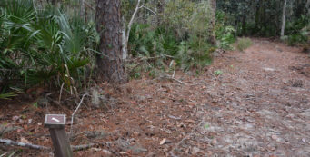 Beecher Run Nature Trail A stop along the Bartram Trail, the Beecher Run Nature Trail at Welaka National Fish Hatchery provides a walk beneath ancient pines along the edge of the hatchery ponds, which are fed by historic Beecher Spring.
 Paddling the Bartram Trail in Welaka Learning how botanists William and John Bartram traveled along the St. Johns River in the 1700s, I followed an experienced river guide for a look at part of the Bartram National Recreation Trail from the water on our Bartram Adventure Tour in Palatka.
- Silver Springs Springside Trails - April 18, 2026
- Silver Springs River Trail - April 17, 2026
- Shamrock Park - April 16, 2026