
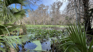
When Silver River State Park opened in the early 1980s, the River Trails were the first footpaths to be established to the Silver River.
The trail system rapidly expanded to include the park’s extensive upland habitats, with routes changed and partially renamed by 2026.
 The original archway dates to the park’s opening
Both of these original trails offered different takes on on the Silver River’s flow.
With the Swamp Trail absorbed into the longer, newer Silver Trail, our focus for the “River Trails” shifts to the original oldie, the 2.3 mile River Trail.
It drops into the floodplain, reaching a river landing in a mile before looping through a bottomland paralleling the river’s flow.
 The overlook is on a bend on the Silver River
Resources




Disclosure: As authors and affiliates, we receive earnings when you buy through our links. This helps us provide public information on this website.
Overview
Location: Silver Springs
Length: 2.3 miles
Trailhead: 29.200623, -82.035628
Address: 1425 NE 58th Avenue, Ocala
Fees: $8 per vehicle
Restroom: At the trailhead
Land Manager: Florida State Parks
Phone: 352-236-7148
Open 8 AM to sunset. Leashed dogs welcome. Cyclists share these trails.
Directions
From Interstate 75 exit 352 in Ocala, follow SR 40 for 8.4 miles through Ocala to Silver Springs. Turn south on SR 35, driving another 1.1 miles to the south entrance to Silver Springs State Park on the left. Stop and pay your entrance fee at the ranger station and proceed to the end of the park road, turning in at the picnic area parking lot.
Hike
Begin your hike at the big kiosk labeled Trailhead and grab a map. Walk down the slope to the split-rail fence.
Turn right, passing an assemblage of vintage buildings from around the county while walking along the edge of the Pioneer Village.
 Trailhead
Emerge at the parking area for the Silver River Museum, open to the public on weekends.
Follow the broad sidewalk to the entrance marked River Trail. A well-worn footpath leads to a trail junction with the newly named Silver Trail.
 Start of the footpath
Bear right to begin the River Trail, walking beneath tall southern magnolias in the hardwood forest.
Pass a bench before the trail empties out onto a forest road behind the cabin area. Turn left.
 Among the magnolias
The graded road descends into the floodplain forest where Marshall Swamp flows towards the Silver River.
It’s a colorful walk in early winter from leaves changing on the red maples and sweetgums.
 Descent to the floodplain
At 0.4 miles, reach a junction with a large kiosk and signage. The newly designated Silver Trail continues straight ahead into swamp.
Make a left to follow the trail to the river on a graded causeway surrounded by swamp.
 Trail junction at kiosk
Gaining elevation, emerge onto high ground between swamp and river, topped with cabbage palms and floodplain trees.
The blue posts continue down a causeway emerging at a grassy open area with a large sheltered bench and kiosk at a mile.
 Sheltered bench
Straight ahead is a boardwalk leading to a landing on the Silver River. Kayakers stop here for a rest break when paddling up from Ray Wayside Park.
A paddle from there to the springs and back again is a seven-mile round trip, or as friends joke, six miles upriver, one down.
 Paddlers at the landing
With its long bench, the observation deck above the landing provides a great view of both bird and human activity on a curve in the river.
Leave the boardwalk and turn left to follow the blue posts on a mowed path through the riverside forest.
 Start of the bottomland loop
When the river recedes after a flood, squishy spots and mud puddles dot the footpath.
Orange-hued chalky bluestem grass waves below the cabbage palms. Worn paths afford views of the river and its rafts of lilies up close.
 Bottomland path
Tall cypresses rise on the far shoreline. Taking side paths, be mindful that alligators and water mocassins like the river edge, too.
A bench sits in a clearing at a very showy overlook beneath the trees.
 The best overlook
Past the bench, the path curves away from the river, entering a dense palm hammock.
Looping west, it once again becomes a grassy ribbon between cabbage palms and red maples.
 A bench in the bottomland forest
Emerge from the loop at 1.7 miles at the clearing with the sheltered bench. Turn left to exit along the causeway through the floodplain.
Meeting the Silver Trail at the kiosk, turn right. The route remains shared up the road, turning into the forest before the park cabins.
Exit to the parking area and to the path past the Pioneer Village, finishing this 2.3 mile hike at the trailhead.
 Returning through the forest
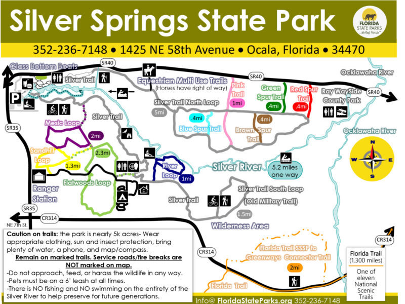
Trail Map
Explore More!
Learn more about Silver Springs State Park
 Silver Springs State Park One of the world's largest and deepest springs, Silver Springs pours out more than 550 million gallons of water daily, forming the Silver River.
Slideshow
See our photos from the River Trail
Nearby Adventures
 Silver Springs Conservation Area Silver Springs Conservation Area protects upland habitats crucial to recharge of Silver Springs. Two stacked loop trails (with a cross-trail on the upper loop) provide several options for hiking.
 Florida Trail, Marshall Swamp 3 miles. Marvel at towering trees in an ancient forest along this Florida Trail segment on the Cross Florida Greenway.
 Indian Lake Bear-N-Oak Trail The Bear-N-Oak Trail at Indian Lake State Forest provides a fascinating look at karst terrain centered on Indian Lake, a sinkhole lake that connects to Silver Springs via the Floridan aquifer.
 Florida Trail, Cross Florida Greenway 43.8 miles. A prime destination for backpacking and day hiking south of Ocala, the Florida Trail follows the Cross Florida Greenway between the Withlacoochee and Ocklawaha Rivers.

- Hal Scott Red Trail - November 13, 2026
- Baseline Trails - November 7, 2026
- Hal Scott Yellow Trail - November 3, 2026