
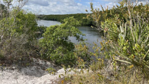
Behind the Elsa Kimbell Environmental Center at Jonathan Dickinson State Park, scrubby flatwoods blanket the bluffs above the Loxahatchee River.
The River Trail navigates a narrow path carved into them, sometimes well above the river, following a series of numbered posts.
 View upriver from Marker 5
A spur trail into the mangrove forest shifts the perspective, creeping between prop roots. Time your trek for low tide, and you’ll be able to walk deep into this magical landscape.
Three different approaches to the River Trail let you choose your own adventure. Behind the environmental center, Post #1 marks the start of the loop.
Campers can start from a spur along the mangrove forest at the River Campground. As day users, we began our hike from the same parking area as the Kitching Creek Nature Trail.
 Deep into the Mangrove Spur
Resources





Disclosure: As authors and affiliates, we receive earnings when you buy through our links. This helps us provide public information on this website.
Overview
Location: Hobe Sound
Length: 1.4 miles
Trailhead: 26.991858, -80.143673
Address: 16450 SE Federal Highway, Hobe Sound
Fees: $4-6 per vehicle
Restroom: At the picnic areas and the Kimbell Center
Land Manager: Florida State Parks
Phone: 772-546-2771
Open 8 AM to sunset. Ask for an interpretive map of the trail at the entrance station or look for one at the Kimbell Center.
Mosquitoes can be fierce along the Mangrove Spur much of the year. This side trail is at river level so be alert for snakes and alligators.
Leashed dogs welcome, but the trails are narrow. Please restrain your dog when others are near.
Directions
From Interstate 95 or Florida’s Turnpike at Jupiter, head east on Indiantown Rd. for 1.1 miles before bearing left onto Center St. In 2.3 miles, turn left at A1A, continuing a mile before making a left on US 1. Drive north 3.7 miles on US 1 to the park entrance on the left. Once past the entrance station, make a right at the T and follow the main park drive 4 miles. Turn slightly right at this road juction to park at the riverfront day use area. Alternatively, shorten your walk to just the interpretive loop by making a left and parking at the Kimbell Center on the right to access the interpretive loop portion of this route through the center.
Hike
A sidewalk leads from the day use parking through the picnic area towards the concession with its bike and canoe rentals.
Walk around the building’s outside dining area above the docks to follow the sidewalk towards the Kimbell Center.
 Riverfront picnic area
Scattered longleaf rise above a riverfront picnic area and kayak launch. Along a lawn sloping to river level, trace the arc of a gentle curve in the Loxahatchee River.
The pathway proceeds to the McNeill Pavilion chickee, Marker 4 along the River Trail interpretive loop.
 McNeill Pavilion
Walk along the front of the chickee, leaving the sidewalk to descend the grassy slope towards its stage. Continue past it at the edge of the grassy area.
At a quarter mile, Marker 5 points out the Loxahatchee River below the bluff and the start of a sandy footpath along it.
 Access to the River Trail near the McNeill Pavilion
Now significantly tidal, the river contains enough salt water that mangroves thrive along it. Look down on the river at Marker 6.
Between the brackish waters and erosion during floods, once-statuesque pines atop the bluffs are dead or barely clinging to life atop the exposed scaffolding of their root systems.
 Pine roots clinging to the sand bluff
Past more dropoffs and pines with exposed roots, squeeze through a dense thicket of scrub oaks and saw palmetto. Emerge at a clearing at a four-way trail junction at 0.3 mile.
Marker 7 beckons at the entrance to a tunnel in the vegetation, the start of the Mangrove Spur.
 Entrance to the Mangrove Spur
Duck under the canopy and follow the curve to a beaten path slightly above river level behind the sinuous prop roots of the red mangroves edging the Loxahatchee River.
As boaters pass, waves lap beneath the trees, the ribbon of water reflecting light in an otherwise shaded corridor.
 Tropical hammock
Climb into a tropical hammock, cabbage palms and pines towering well above dense growth of cocoplum, and settle to river level again, nose to nose with red mangroves.
The beaten path turns sandy as it creeps into the river basin. If it’s low tide, this short stretch will be damp but walkable, worthwhile to continue.
 Sandy soggy spot
Gain a little elevation and a lot of duff underfoot to walk a palm-lined corridor behind the mangrove forest.
Swing through a possibly soggy nursery of red mangroves sprouting from their upright bean-shaped seeds edges close to the river.
 Mangrove nursery
Ascend slightly to traverse an incredible forest of mature red mangroves, the footpath winding through a showy maze of roots and limbs.
Leaving the edge of this higher ground, the path continues through mature mangroves at river level. Access is tidally influenced.
 Mature mangrove forest
Slightly sticky mud becomes puddly, and eventually, flooded. Choose a turn-around point for the Mangrove Spur based on the conditions.
We returned to Marker 7 after 0.6 mile. Marker 8 is immediately across from it. Turn right, however, to add a 0.2 mile spur.
 Turn around when water levels make it tough to continue
This narrow tunnel through dense vegetation follows the ecotone between scrubby flatwoods and mangrove forest, with a little tropical hammock edging in.
Pass an unmarked path on the left which meets the loop and another on the right which burrows into the mangrove forest towards the Mangrove Spur but does not reach it.
 Tunnel of vegetation towards the campground
The shady corridor pops out at the edge of River Campground. Turn around and return to Marker 8 and make a right. Walls of scrub oaks and saw palmetto line this narrow path.
A tall pine is a beacon for the straightaway, the high walls of vegetation relaxing into a picturesque scrub forest on the approach to the pines.
 Scrub near Marker 9
The campground shortcut comes in from the right. Marker 9 denotes a nest cavity for a pileated woodpecker in a pine snag, one of a series of burnt pine trunks in the scrub.
Narrowing through the dense scrub, the path through the scrubby flatwoods opens up to reveal the thatched roof of the McNeill Pavilion chickee ahead.
 Passing behind the pavilion
Slip through low scrub behind it, coming to a crossroads of unmarked paths. Continue straight ahead through this immersive habitat to the Kimbell Center.
Meet a broad sandy path at a mile. The back door of the center is within view. If you haven’t visited the center, do.
 Approaching the Kimbell Center
Dioramas illustrate the mosaic of habitats found in this immense state park. Learn about Trapper Nelson, a colorful character who lived on an island in the Loxahatchee River.
Illustated panels explain this landscape was once Camp Murphy, the Army’s first and most secretive radar school established in 1942 to train soldiers during WWII.
Transfer of the Army installation to the state of Florida enabled Jonathan Dickinson State Park to open in 1960. The center also has a gift shop and restrooms.
 Diorama about scrub habitat
Directly behind the center, Marker 1 calls attention to the scrubby flatwoods habitat that surrounds it. Marker 2 denotes the tall slash pines above.
To the west along the broad sandy path, Marker 3 adjoins a wooden fence and an illustrative prescribed burn of crispy understory plants and charred pine trunks.
 Marker 1
Make the left after it to close the loop at Marker 4, next to the McNeill Pavilion. Take the sidewalk back through the riverfront picnic area to the concession area and docks.
Add to the walk by continuing straight ahead along this accessible path, along the edge of the day use picnic area, to reach the ramp to a boardwalk along the river.
 Day use area sidewalk beyond the concession
The boardwalk provides an up-close view of the expanse of the Loxahatchee River, boaters and kayakers and tour boats slipping past in the main channel.
At the end where the tour boats to Trapper Nelson’s island are docked, a staircase leads up to the concession building. Head for the day use parking area to conclude a 1.4 mile hike.
 Riverfront boardwalk to the docks
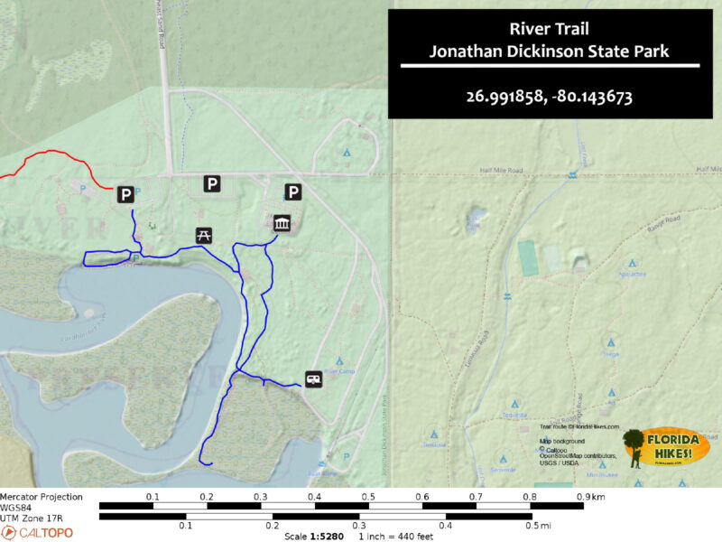
Trail Map
Explore More!
Learn more about Jonathan Dickinson State Park
 Jonathan Dickinson State Park One of South Florida's best backpacking destinations, Jonathan Dickinson State Park encompasses a vast mosaic of ecosystems along the wild and scenic Loxahatchee River.
Video
A walk through the River Trail
Slideshow
See our photos from the River Trail
Nearby Adventures
 Kitching Creek Nature Trail On the Kitching Creek Nature Trail, immerse in a small corner of the vast pine flatwoods communities extending across Jonathan Dickinson State Park.
 Hobe Mountain Trail Catch sweeping views in every direction atop the highest natural hill south of Lake Okeechobee on the Hobe Mountain Trail at Jonathan Dickinson State Park.
 Hobe Sound National Wildlife Refuge Straddling both sides of the Indian River Lagoon between Hobe Sound and Tequesta, this refuge provides both sea turtle nesting grounds and Florida scrub-jay habitat.
 Jupiter Inlet Lighthouse Outstanding Natural Area One of only three federally designated ONAs in the United States, Jupiter Inlet Lighthouse Outstanding Natural Area combines a unique location with botanical beauty and history.

- Michael Crotty Bicentennial Park - November 3, 2026
- A.J. Henry Park - November 1, 2026
- Okeeheelee Nature Center Trails - October 22, 2026