
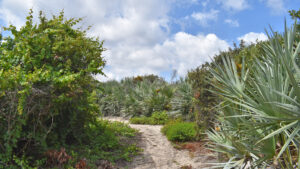
Accessed via Loggerhead Park, the eastern side of Juno Dunes Natural Area has a compelling reason to take a short walk: the view.
Optimized for accessibility, the climb to the high point is gradual but noticeable, ascending twenty feet across a quarter mile to an outstanding panorama in both directions.
 Ridgetop view of the Atlantic Ocean
Resources





Disclosure: As authors and affiliates, we receive earnings when you buy these through our links. This helps us provide public information on this website.
Overview
Length: 0.6 mile round-trip and loop
Trailhead: 26.88563, -80.05580
Address: 14200 US 1 South, Juno Beach
Fees: Free
Restroom: At adjoining Loggerhead Park
Land manager: Palm Beach County
Phone: 561-233-2400
Open sunrise to sunset. No pets, bicycles, or drones allowed. A 0.4-mile round-trip is accessible, the remainder is natural surface.
Directions
From Interstate 95 exit 83, Jupiter, follow Donald Ross Blvd east 4.4 miles to US 1. For Juno Dunes East, be sure to be in the rightmost left turn lane, as the turn into Loggerhead Park is a quarter mile north of the intersection. Drive over the ridge past the Loggerhead Marinelife Center and park behind it to the left to find the trailhead.
Hike
A trailhead kiosk sits in the northwest corner of the parking area, the accessible Seagrape Nature Trail starting out under as a tunnel under the sea grapes.
Coastal hammock and coastal scrub define the habitats on the eastern slope of the Atlantic Coastal Ridge, where the Celestial Railroad operated between 1889 and 1896.
 Start of the Seagrape Trail
The narrow gauge Jupiter & Lake Worth Railroad connected Juno and the Jupiter Lighthouse, with stops at stations called Venus and Mars.
It shuttered when Henry Flagler railroaded right around Jupiter and Juno Beach, bypassing them with his Florida East Coast Railway.
 Tunnel of trail under sea graps and tropical trees
Under the dense canopy of trees, the trail takes a gentle gradient uphill, much like the railroad would have done.
Emerging from the tunnel into a bright landscape with silvery-blue saw palmetto, you’re along the edge of the scrub that tops the ridge.
 Open dunes
Around the next curve, another low canopy of tropical trees like myrsine and gumbo-limbo cast shade.
A trail marker on a curve notes the return route of the loop. Stay with the paved path.
 Curve past the incoming marked footpath
Climbing more steeply into the coastal scrub, the open nature of this part of the trail makes for a cool breeze off the ocean and a strumming sound from the surf.
At 45 feet above sea level, the high point is topped with a observation shelter containing benches.
 The shelter on the ridge
To the west, the Intracoastal Waterway and the sweep of preserved habitats at Juno Dunes West is visible on the far side of US 1.
To the north, a tall condo looms. But the view towards the Atlantic is otherwise a horizon line of ocean with the coastal scrub as its foreground.
 View to the northwest
At 0.2 mile, this marks the end of the accessible path. Hikers, however, can head straight down the sandy slope on the Royal Tern Trail.
This natural surface part of the loop barrels downhill fast, losing 26 feet of elevation in a tenth of a mile.
 The sandy footpath descends steeply
After another bower of sea grapes, the deep shade of a tropical hammock envelopes the footpath, which narrows greatly.
At the trail junction, the route straight ahead leads to a crossover on A1A to the beach, a quarter mile round trip from this point.
 The trail is in a tunnel of tropical forest
Add on that side trip if you like, or save the beach for after the hike, as it’s easily reached through Loggerhead Park, too.
Making a right at the junction, follow the footpath along the yellow dot markers as it climbs out of the deep shade and onto the scrub-covered hillside.
 An uphill climb
Ascend between clusters of silver-tinged saw palmetto as the trail leads uphill, reaching the junction with the paved Seagrape Trail.
This concludes the loop. Make a left, passing some wild coffee, and retrace the paved trail down to the trailhead to finish the 0.6 mile walk.
 Walk beneath sea grapes to exit
Trail Map

Explore More!
Learn more about Juno Dunes Natural Area
 Juno Dunes Natural Area Preserving a sliver of the Atlantic Coastal Ridge at the north end of Juno Beach, this expansive preserve extends from the Intracoastal Waterway to A1A.
Video
A virtual walk at Juno Dunes East
Slideshow
See our photos of Juno Dunes East
Nearby Adventures
More worth exploring while you’re in this area.
 Juno Dunes West Traverse a gradient of habitats interrupted by a basin marsh along the scrubby slopes of the Atlantic Coastal Ridge to the mangrove-fringed edge of Frenchman's Creek.
 Frenchman’s Forest Natural Area Four hiking trails intertwine in this 172-acre natural area, with seven different habitats to explore along footpaths, paved trails, and boardwalks.
 Jupiter Riverwalk Fronting the eastern shore of the Intracoastal Waterway for more than two miles, the Jupiter Riverwalk is a scenic urban walkway connecting hotels, dining, and natural areas.
 DuBois Park Fronting Jupiter Inlet where the Indian River Lagoon meets the Loxahatchee River, this breezy park has one of the most beautiful waterfronts in the region.

- Hal Scott Yellow Trail - November 3, 2026
- Hal Scott Preserve - October 28, 2026
- Tradewinds Park - October 27, 2026