
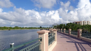
It’s been over a decade since we first encountered the budding Jupiter Riverwalk, then comprising a pretty bridge along the Intracoastal between the Best Western and the marina.
Jupiter has grown since, and so has the Riverwalk. It’s been an integral part of new development along the waterway. Two miles of the intended 2.5 are now complete.
 Sunset over the Lagoon Bridge from the Best Western
Resources





Disclosure: As authors and affiliates, we receive earnings when you buy these through our links. This helps us provide public information on this website.
Overview
Length: 2 miles linear
Trailhead: see Directions map
Address: 800 US 1 South, Jupiter
Fees: Free
Restroom: At Harborside Place
Land manager: Town of Jupiter
Phone: 561-746-5134
Leashed pets welcome; please clean up after your pets. This is part of the East Coast Greenway, but cyclists are required to dismount and walk bikes for 0.4 mile of the route.
Directions
From Interstate 95 or Florida’s Turnpike in Jupiter, drive east along Indiantown Rd for 4 miles. Turn right onto US 1. The closest parking to this intersection is at the Plaza Down Under, beneath the bridge you just crossed—make the first right to go under the bridge for parking, which is not open before 8:30 AM. You may also park in the lots of the following businesses shown on the map above: the Jupiter Yacht Club, the Best Western, and Mangrove Bay. Do not park at Mangrove Bay or the Best Western during special events. A small parking area at Jupiter Ridge Natural Area is 0.3 mile south of the Riverwalk entrance, with access by sidewalk paralleling US 1.
Hike
The south end of the Riverwalk starts across US 1 from Ocean Way, a road connecting to A1A that is posted as part of the East Coast Greenway.
We’ve both biked in from A1A and walked up from Jupiter Ridge Natural Area to reach it. Parking is available in both locations.
Edged by hedges along a condo complex, the broad path follows the outline of the property, skimming along the north end of the scrub habitat of Jupiter Ridge.
 Scrub at Jupiter Ridge Natural Area
Curving around the last of the scrub, it reaches the mangrove-lined edge of Old Lake Worth Creek just as it comes to Mangrove Bay, another large condo complex.
Where the Riverwalk slips behind the condos and an adjoining assisted living complex, a connector path leads towards its parking area on US 1.
Passing behind an office building with a view of the mangroves and creek, it circles the pool behind the Best Western.
At 0.7 mile is a T intersection, the original Riverwalk entrance from US 1 coming in from the right. Turn left.
 Entrance corridor next to the Best Western
This is the start of the showy Lagoon Bridge, extending across a natural lagoon in Lake Worth Creek. Cyclists are asked to dismount and walk bikes across.
It’s the hot spot for both birding and sunsets along the Riverwalk, and is gently lit after dark. Boats slip past along the Intracoastal Waterway.
 Looking south along the Lagoon Bridge
The bridge ends within a tenth of a mile, depositing the Riverwalk into the Jupiter Yacht Club Marina. Again, cyclists are asked to refrain from riding.
The reason is clear, as the brick path makes sharp turns as it edges along the docks. Yachts and smaller craft are moored in slips.
From water level, zigzag up a ramp to reach street level, where an array of restaurants overlook the marina. It’s here cyclists can resume riding, a mile into the Riverwalk.
 Riverwalk in the Marina
Landscaped and well above the waterway, the Riverwalk continues along another curve in the old creek.
Step out onto the observation decks for views of a small mangrove island and of watercraft passing under the Indiantown Rd bridge.
Turning left, the walkway leads beneath this drawbridge into the event plaza, where we’ve stumbled into a craft fair in progress. Normally, there is Riverwalk parking under the bridge.
 Indiantown Rd bridge
On the north side of the bridge is Harbourwalk Place, a dense urban village of residences, shops, hotels, and restaurants.
The Riverwalk stays along its edge, adjoining Dockside Circle. Mangroves edge the waterfront. Pass by the Wyndham Grand Jupiter Hotel.
 The Riverwalk along Dockside Circle
At the north end of Harbourwalk Place, the Riverwalk ends, 2 miles from its start at Ocean Way.
Future plans are for it to continue north across “the Oxbow” surrounding Burt Reynolds Park and up to Jupiter Inlet.
However, construction along US 1, including the closure of the drawbridge bridge north of the park, precludes any extension until that work is complete.
Turn around here to return to Ocean Way. Depending on your starting point (A1A or Jupiter Ridge), this can be up to a 4.8 mile round-trip walk.
 There are many covered observation stops along the walk
Trail Map

Explore More!
Slideshow
See our photos of the Jupiter Riverwalk
Nearby Adventures
More worth exploring while you’re in this area.
 DuBois Park Fronting Jupiter Inlet where the Indian River Lagoon meets the Loxahatchee River, this breezy park has one of the most beautiful waterfronts in the region.
 Juno Dunes Natural Area Preserving a sliver of the Atlantic Coastal Ridge at the north end of Juno Beach, this expansive preserve extends from the Intracoastal Waterway to A1A.
 Jupiter Inlet Lighthouse Outstanding Natural Area One of only three federally designated ONAs in the United States, Jupiter Inlet Lighthouse Outstanding Natural Area combines a unique location with botanical beauty and history.
 Coral Cove A spectacular example of a rare type of Florida coastline, Coral Cove features a dramatic rocky shoreline carved into unusual shapes by the waves of the Atlantic Ocean.

- Baseline Trails - November 7, 2026
- Hal Scott Yellow Trail - November 3, 2026
- Hal Scott Preserve - October 28, 2026