
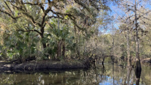
Named after an outspoken conservationist and Friends of the Econ founder, Ken Bosserman Econlockhatchee River Preserve protects over 240 acres of ecologically sensitive land.
It lies within its namesake river basin to the east of Orlando, north of SR 50.
Orange County began acquiring parcels in the 1990s to make up the preserve, which forms a wildlife corridor with neighboring protected lands to the north and south.
Once the county established a trail system, this unique property opened to the public in late 2025.
 Along the Orange Trail
The well-marked, hiking only trails consist of a quarter mile approach trail, a 0.6 mile main loop and a short spur that explores swampy sloughs adjacent to the river.
Along the route, two picnic tables and a bench provide options for taking a break while immersed in this patch of scenic wilderness.
Due to its proximity to the river, parts of the trail tend to be muddy after heavy rains, and the western side of the loop will be underwater if the river is flooded.
 Riverside bench during a flood
Resources





Disclosure: As authors and affiliates, we receive earnings when you buy through our links. This helps us provide public information on this website.
Overview
Location: Bithlo
Length: 1.2 miles
Trailhead: 28.584278, -81.164944
Address: 14801 Lake Pickett Rd, Orlando
Fees: Free
Restrooms: None
Land manager: Orange County
Phone: 407-836-1400
Open sunrise to sunset. Leashed dogs welcome.
Directions
From the intersection of SR 50 and Alafaya Trail in east Orlando, head east on SR 50 for 1.5 miles before turning left onto Lake Pickett Rd. In 1.1 miles, turn right at a stop sign to remain on Lake Pickett Rd. A small parking area will be on the left side of the road in 0.9 mile, shortly after crossing the Econlockhatchee River.
Hike
Beginning the hike at an information sign next to a wooden fence, follow blue trail markers as they lead along a tree line and into the woods.
A wide corridor bordered by dense palmettos winds northward under a canopy of mixed hardwoods and sporadic pine trees.
Shortly after passing a picnic table, the path curves to the west, crossing a wide clearing under high tension powerlines.
 Picnic table near the trailhead
The trail enters a shady forest on the other side where low spots have potential to hold water, which may require fancy footwork to maneuver without getting wet shoes.
At a quarter mile, the trail opens to a grassy field where a house once stood. Follow orange trail markers to a picnic bench standing alongside a memorial magnolia.
 Puddle on the Blue Trail
From this point, look for orange blazes to the west to start the loop in a clockwise fashion, reaching the river more quickly in case flooding blocks the path.
A mix of oak, cabbage palm, and sweetgum rises from the leafy forest floor as the trail descends towards the wetlands.
 Heading into the floodplain
As the path curves northward, conspicuous cypress knees jut out of the dark soils, accompanied by large cypresses climbing high into the overstory.
Orange blazes lead across a shaded landscape sprinkled with tufts of grass among trees showing distinct waist-high waterlines.
As the river becomes more visible through the trees, an oxbow sends tannic waters past a large live oak at a particularly scenic confluence.
 River junction
Shortly before turning away from the water, a well-placed bench offers a place to sit and enjoy peaceful scenery along the bank.
Trees from the opposite shore are mirrored on the river’s glassy surface. The trail continues north, climbing ever-so-slightly from the river.
Traverse rolling terrain between sloughs, reaching a junction with the yellow spur in 0.2 mile.
 Riverside bench
Yellow blazes lead along short loop on raised ground between the river and a swampy slough, returning to the main trail in about a tenth of a mile.
Follow the Orange Trail as it weaves southward while ascending into a hydric hammock with drier soil.
In less than a half a mile, turn left where the loop concludes, continuing along the Blue Trail for another quarter mile back to the trailhead.
 Yellow Loop
Trail Map

Explore More!
Video
Hiking Ken Bosserman Econlockhatchee River Preserve
Nearby Adventures
 Econlockhatchee Sandhills CA In the floodplain of the Econlockhatchee River, Econlockhatchee Sandhills Conservation Area is a 706-acre showcase of upland habitat diversity with a 3.2 mile loop trail.
 Long Branch More than 6 miles of interconnected trails east of the Econlockhatchee River explore natural habitats on ranch land undergoing habitat restoration.
 Pine Lily Preserve In every season, wildflowers are the highlight along more than 4 miles of trails at Pine Lily Preserve, where its namesake lilies bloom in late summer.
 Savage Christmas Creek Preserve Protecting more than a thousand acres, Savage Christmas Creek Preserve east of Orlando has more than 8 miles of trails through panoramic prairie and pine flatwoods landscapes.

- Kelly Park - November 18, 2026
- Wekiwa Springs Hiking Trail - November 17, 2026
- Black Lake Preserve - November 15, 2026