• Skip to main content
  • Skip to header right navigation
  • Skip to after header navigation
  • Skip to site footer
Florida Hikes logo

Florida Hikes

Hike Bike Paddle Camp Florida with authors Sandra Friend and John Keatley as your guides

  • Trails
  • Maps
  • Guidebooks
  • Hike
    • Scenic Hikes
    • Loop Trails
    • Dog-friendly Hikes
    • Hikes for Kids
    • National Parks in Florida
    • Florida State Parks
  • Bike
    • Major Bike Trails
    • Paved Bike Trails
    • Off Road Biking
    • Biking Articles
  • Paddle
    • Canoe & Kayak Rentals
    • Paddling Destinations
    • Paddling Articles
  • Camp
    • Cabin Rentals
    • Car Camping
    • Primitive Camping
  • Florida Trail
    • Plan your Hike
    • Best Scenic Hikes
    • Best Backpacking
    • Section Hiking
    • Thru-Hiking
    • Trail Updates
  • Travel
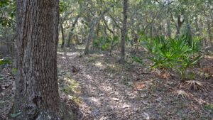
Footpath through oak hammock

Naval Live Oaks Area

Spanning from Santa Rosa Sound to Pensacola Bay, Naval Live Oaks Area is one of America’s oldest federally protected forests, now part of Gulf Islands National Seashore.

Gulf Breeze (30.363867,-87.130483)   6.5 miles   Gulf Islands National Seashore

Along windswept shorelines, a dense hardwood forest persists between Pensacola Bay and Santa Rosa Sound.

Created by an executive order by President John Quincy Adams in 1828, Naval Live Oaks Area remains federal land, now in Gulf Islands National Seashore.
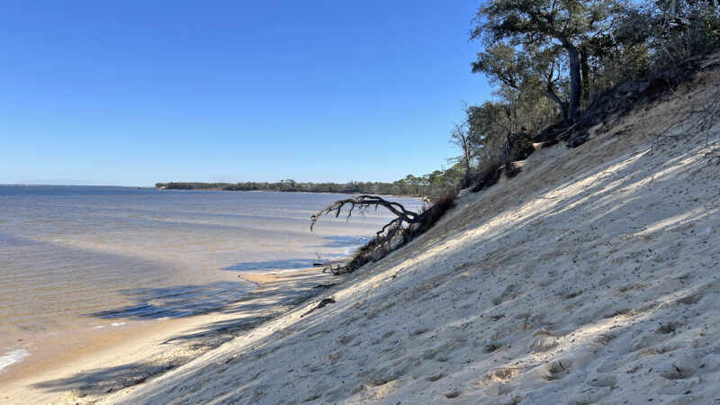
Steep sand bluff along bay
Steep sand bluff on Pensacola Bay

Resources

Resources for exploring the area
Florida Trail Hikes book cover The Florida Trail Guide book cover North Florida Panhandle Explorers Guide book cover Hikers Guide to the Sunshine State book cover Paddlers Guide Florida The Hiking Trails of Floridas National Forests Parks Preserves book cover Hiking the Gulf Coast book cover
 
Disclosure: As authors and affiliates, we receive earnings when you buy through our links. This helps us provide public information on this website.

Overview

Location: Gulf Breeze
Address: 1801 Gulf Breeze Parkway, Gulf Breeze
Fees: Free
Restroom: At the picnic areas
Land manager: National Park Service
Phone: 850-934-2600

Open 8 AM to sunset. The visitor center at park headquarters has closed permanently.

Cyclists are welcome to use any of the trails at the Naval Live Oaks Area except for the Brackenridge Trail.


Directions


From Pensacola, follow US 98 east over the Pensacola Bay Bridge to Gulf Breeze. Continue east on US 98 another 1.9 miles past the exit to Pensacola Beach to the main entrance for the headquarters building and visitor center.

About the Park

Set aside in 1828 by President John Quincy Adams as the first federal tree farm, Naval Live Oaks was deemed strategic to the young United States Navy.

Florida was only a United States Territory at the time. As a deep water port, Pensacola Harbor immediately acquired a naval presence which included a shipyard.

Hand drawn map of Pensacola Bay and islands around it Pensacola Bay in 1861 (State Library of Florida, Florida Map Collection)


Henry Brackenridge was hired as a forester to tend to the old-growth live oak trees. Shipbuilding was an important enterprise in Pensacola.

Live oaks provided a strong, heavy timber for ships and were especially prized for their thick curved limbs for ship hulls.

interpretive sign in forest with illustration of wooden hull Interpretation of how the live oaks were used


By the Civil War, ironclad ships were in use. Wooden ships became a thing of the past. Most of the original Live Oak Reservations were released to military and agricultural use.

We were fortunate to first hike at Naval Live Oaks Area decades ago when there were still many ancient live oaks to be found.

Illustrated sign and large live oaks Interpretive sign among the live oaks in 2006


Protected for nearly two centuries, this oak grove became part of Gulf Islands National Seashore, which preserves coastal military sites from Fort Walton Beach to Biloxi.

Unfortunately, the oaks’ advanced age and battering by a barrage of hurricanes means there are now very few left. However, the preserve remains deeply wooded.

The main parking area for Naval Live Oaks is at Park Headquarters on the south side of Gulf Breeze Parkway (US 98). A paved bike path leads here from Gulf Breeze along US 98.

Large oaks creating canopy in shady woods Live oaks along the Brackenridge Trail


Headquarters Area

Park near the headquarters building. An easy-to-reach observation deck behind it provides a sweeping view of Santa Rosa Sound and interpretive information.

The 1.1 mile Brackenridge Trail begins at the west end of the deck. The shortest of the park’s trails, it has two loops largely in shade.

Kiosk with Brackenridge Trail sign and boardwalk Brackenridge Trail


A quarter mile boardwalk loop tunnels into the woods. Off the west end of this accessible portion, join a footpath through the oak forest.

Start a second loop counterclockwise. It leads to a scenic overlook on the bluffs above Santa Rosa Sound. Return back along the sound side of both loops.

Anglers have access to a small sandy beach on the sound. Kayakers can launch here.

A sidewalk leads east to connect the Brackenridge Trail with the Santa Rosa Sound Day Use Area. It’s a little less than a quarter mile between the two.

Pine woods along sandy beach Sound side beach


Santa Rosa Sound Day Use

At the east end of the parking area shared with park headquarters, a picnic area along Santa Rosa Sound adjoins the park’s restrooms.

Some picnic tables are waterfront, others are tucked in the pine forest. There is one large picnic pavilion in the complex.

Pines and pine trunks frame picnic area with water to horizon beyond Picnic area on Santa Rosa Sound


Pensacola Bay Day Use

The entrance to the Pensacola Bay side is on the north side of US 98 about a half mile west of the Headquarters entrance.

Follow the entrance road back to where a right turn leads to the trailhead parking area by the maintenance shed.

Trailhead kiosk with footpath Naval Live Oaks Trails trailhead


The Naval Live Oaks Trails start at a kiosk at the north end of the parking lot. A short connector trail leads to the Jackson Trail.
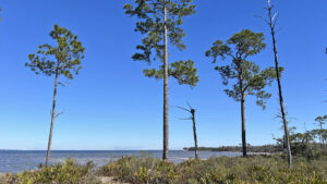
Bayfront forest with tall pines Naval Live Oaks Trails One of the most compelling hiking destinations near Pensacola, the trails on the Pensacola Bay side of Naval Live Oaks Area offer outstanding scenery and surprisingly hilly terrain.

A backbone to the trail system, this historic linear path stretches east and west the length of the preserve, with walk-in entrances at its ends.

Broad sand trail with deep soft sand with tire ruts The Jackson Trail is broad and sandy


Take it west briefly to meet the gated portion of the entrance road and walk up the road to the Youth Group Camping Area.

Centered on a large picnic pavilion, this waterfront complex has gorgeous views across Pensaola Bay between the pines and direct access to its shoreline.

Bay beyond line of pines Pensacola Bay view from the camping area


Hikers can go east or west on the trail system by using the Jackson Trail to make loops with trails that branch off it.

Our trail map below illustrates the 5.4 mile route we explored. The highest sand bluffs are to the west. A freshwater pond is an unexpected feature to the east.

Hikers in scrub forest Hiking in scrubby flatwoods


Trail Map
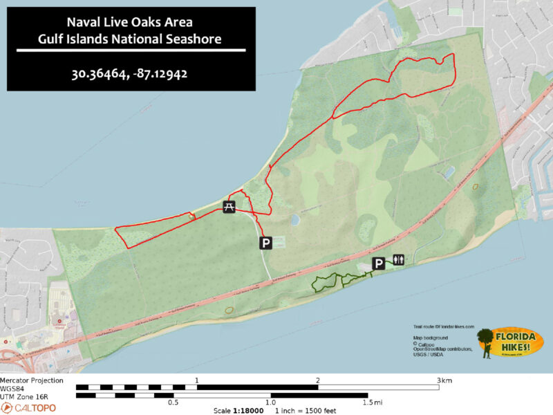
Naval Live Oaks Area Trail Map
Green: Brackenridge Trail and connector to picnic area. Red: Our suggested route on the Naval Live Oaks Trails.

Explore More!

Slideshow

See our photos of Naval Live Oaks Preserve


Nearby Adventures

More worth exploring while you’re in this area.

Wetlands with boardwalk beyond Shoreline Park Explore a network of well-maintained and signposted nature trails threading through natural habitats atop bluffs and within wetlands along the shoreline of Santa Rosa Sound.
Fort Pickens Fort Pickens With more than seven miles of beaches along Santa Rosa Island, the Fort Pickens Unit at Gulf Islands National Seashore is a compelling destination at Pensacola Beach.
Florida Trail Seashore Dunes Florida Trail, UWF/SRIA Dunes Preserve 3.2 miles. At the UWF/SRIA Dunes Preserve on Santa Rosa Island, the Florida Trail traverses a series of coastal habitats cradled by the sweeping dunes, providing a one-of-a-kind hike.
Pine savanna at Garcon Pont Garcon Point Trail Pitcher plants and orchids accent expansive coastal prairie landscapes and diverse pine flatwoods along a series of trails at Garcon Point.

Park Maps (PDF) Official Website

  • Author
  • Recent Posts
Sandra Friend & John Keatley
Articles jointly researched, written, and photographed by Sandra Friend & John Keatley, authors and publishers of FloridaHikes.com.
Sandra Friend & John Keatley
Latest posts by Sandra Friend & John Keatley (see all)
  • Hal Scott Red Trail - November 13, 2026
  • Baseline Trails - November 7, 2026
  • Hal Scott Yellow Trail - November 3, 2026
Category: Hikes, Loop Hikes, Nature Trails, Northwest Florida, TrailsTag: Big Trees, Birding, Family-Friendly, Fishing, Group Camping, Gulf Breeze, Gulf Islands National Seashore, Historic Sites, Locations, National Parks, Naval Live Oaks Preserve, Navarre, Notable Trees, Observation Decks, Pensacola, Wildflowers

Sidebar

FarOut Guides

Our comprehensive trail logistics presented on offline maps:

Florida National Scenic Trail (1,500 miles)
Florida Keys Overseas Heritage Trail (108 miles)
Eastern Continental Trail in Florida (92 miles)


We earn a small commission on sales through these links. Thanks for your support!


Our Guidebooks

We’ve written Florida guidebooks for over 25 years. These include Northwest Florida destinations.

Book cover with woman hiking through palms with baby carrier
Book cover of Florida Trail Hikes
The Florida Trail Guide fifth edition
Explorer's Guide North Florida & The Panhandle guidebook

Explore More

Newest Articles for Northwest Florida

Footpath in lush river hammock Florida Trail, Wakulla River
Expanse of lake Jackson View Park
Large pond with a boardwalk on its far shore Pedrick Pond Park
Sweep of bay beyond dunes and path through them Okaloosa Area

  • Facebook
  • Flickr
  • Instagram
  • Pinterest
  • Substack
  • Vimeo

FIND A TRAIL OR PARK

METROS: Bradenton. Clearwater. Crestview. Daytona Beach. Destin. Fort Lauderdale. Fort Myers. Fort Walton Beach. Gainesville. Jacksonville. Kissimmee. Lakeland. Melbourne. Miami. Naples. Ocala. Orlando. Panama City Beach. Pensacola. Port St. Lucie. Punta Gorda. St. Petersburg. Sanford. Sarasota. Sebring. Stuart. Tallahassee. Tampa. Vero Beach. West Palm Beach.

MULTI-REGION: Atlantic Coastal Ridge. Atlantic Coast. Bartram Trail. Big Bend. East Coast Greenway. Everglades National Park. Florida National Scenic Trail. Gulf Coast. Lake Wales Ridge. WATERWAYS: Indian River Lagoon. Intracoastal Waterway. Kissimmee River. St. Johns River. Withlacoochee River.

NORTHWEST FLORIDA: Altha. Apalachicola. Apalachicola National Forest. Big Bend Scenic Byway. Blackwater River State Forest. Blountstown. Bonifay. Bristol. Bruce. Cantonment. Cape San Blas. Carrabelle. Chattahoochee. Chipley. Crawfordville. DeFuniak Springs. Eastpoint. Ebro. Eglin Air Force Base. Freeport. Fountain. Gulf Breeze. Gulf Islands National Seashore. Holt. Madison. Marianna. Milton. Monticello. Mossy Head. Munson. Navarre. Navarre Beach. Newport. Niceville. Panacea. Panama City . Perdido Key. Ponce De Leon. Port St. Joe. Quincy. Santa Rosa Beach. Sopchoppy. South Walton. St. George Island. St. Marks. St. Marks NWR. Sumatra. Vernon. Wakulla. Wewahitchka. Woodville. WATERWAYS: Apalachicola River. Blackwater Bay. Blackwater River. Chipola River. Choctawhatchee Bay. Choctawhatchee River. Coastal Dune Lakes. Ochlockonee Bay. Perdido River. St. Marks River. Wacissa River. Wakulla River. Yellow River.

NORTH FLORIDA: Alachua. Amelia Island. Archer. Baldwin. Branford. Bronson. Bunnell. Callahan. Cedar Key. Chiefland. Crescent City. Cross City. Cross Creek. Dowling Park. Ellaville. Fanning Springs. Fernandina Beach. Flagler Beach. Fort White. Glen St. Mary. Green Cove Springs. Hawthorne. High Springs. Inglis. Jacksonville Beaches. Jacksonville Northshore. Jasper. Jennings. Keystone Heights. Lake Butler. Lake City. Live Oak.Macclenny. Mandarin. Mayo. Mayport. Micanopy. Middleburg. Old Town. Olustee. Orange Park. Osceola National Forest. Palatka. Palatka-Lake Butler Trail. Palm Coast. Palm Valley. Perry. Ponte Vedra. Rodman. Salt Springs. St. Augustine. Starke. Steinhatchee. Suwannee. Suwannee River Wilderness Trail. Suwannee Springs. Talbot Islands. Timucuan Preserve. Trenton. Waldo. Welaka. White Springs. Williston. Worthington Springs. Yankeetown. WATERWAYS: Santa Fe River. St. Marys River. Suwannee River. Tolomato River. Upper Withlacoochee River.

CENTRAL FLORIDA: Altamonte Springs. Apollo Beach. Apopka. Astatula. Astor. Auburndale. Bartow. Babson Park. Bayport. Belleview. Bithlo. Brandon. Brooksville. Bushnell. Canaveral National Seashore. Cassadaga. Christmas. Chuluota. Citrus Springs. Clearwater Beach. Clermont. Coast to Coast Trail. Cocoa. Cocoa Beach. Cross Florida Greenway. Crystal River. Dade City. De Leon Springs. DeBary. Deland. Deltona. Dunedin. Dunnellon. Edgewater. Enterprise. Eustis. Ferndale. Fort Meade. Frostproof. Geneva. Gibsonton. Haines City. Hernando. Hernando Beach. Holopaw. Homosassa. Inverness. Kenansville. Kissimmee. Lake Mary. Lake Wales. Largo. Leesburg. Lithia. Longwood. Lutz. Maitland. Malabar. McIntosh. Melbourne Beach. Merritt Island. Merritt Island NWR. Mims. Mount Dora. Narcoossee/Lake Nona. New Port Richey. New Smyrna Beach. Nobleton. Oak Hill. Oakland. Ocala National Forest. Ocklawaha. Ocoee. Oldsmar. Orange City. Ormond Beach. Osteen. Oviedo. Paisley. Palm Bay. Plant City. Poinciana. Polk City. Ponce Inlet. Port Orange. Ridge Manor. Riverview. Ruskin. Safety Harbor. Silver Springs. Sorrento. Spring Hill. St. Cloud. Tarpon Springs. Thonotosassa. Titusville . Umatilla. Viera. Walt Disney World. Weeki Wachee. Weirsdale. Wimauma. Windermere. Winter Garden. Winter Haven. Winter Park. Winter Springs. Withlacoochee State Forest. Withlacoochee State Trail. Yeehaw Junction. Zephyrhills. WATERWAYS: Alafia River. Halifax River. Hillsborough River. Lake Apopka. Little Manatee River. Ochlawaha River. Rainbow River. Tampa Bay. Wekiva River. Wekiva River Basin.

SOUTHWEST FLORIDA: Alva. Boca Grande. Cape Coral. Charlotte Harbor. Ding Darling NWR. Ellenton. Englewood. Estero. Immokalee. Marco Island. North Port. Osprey. Palma Sola. Palmetto. Pine Island. Port Charlotte. Sanibel Island. Venice. WATERWAYS: Caloosahatchee River. Manatee River. Myakka River. Pine Island Sound.

SOUTH FLORIDA: Arcadia. Basinger. Big Cypress National Preserve. Big Cypress Seminole Reservation. Big Cypress Swamp. Bowling Green. Clewiston. Everglades City. Indiantown. LaBelle. Lake Okeechobee Scenic Trail. Lake Placid. Lakeport. Moore Haven. Okeechobee. Ortona. Pahokee. Palmdale. Port Mayaca. South Bay. Wauchula. Zolfo Springs. WATERWAYS: Fisheating Creek. Lake Okeechobee. Peace River.

SOUTHEAST FLORIDA: Biscayne Bay. Biscayne National Park. Boca Raton. Boynton Beach. Coconut Creek. Coral Gables. Coral Springs. Davie. Delray Beach. Fellsmere. Flamingo. Fort Pierce. Hobe Sound. Hollywood. Homestead. Indrio. Jensen Beach. Juno Beach. Jupiter. Jupiter Farms. Key Biscayne. North Hutchison Island. Ocean to Lake Greenway. Palm Beach. Palm Beach Gardens. Pompano Beach. Redland. Sebastian. South Hutchinson Island. WATERWAYS: Florida Bay. St. Lucie River.

FLORIDA KEYS: Big Pine Key. Islamorada. Key Largo. Key West. Marathon. Overseas Heritage Trail.


©2006-2026, Sandra Friend & John Keatley | Disclosure | Site Index | Work with Us | Advertise with Us | Terms of Service and Privacy Policy

Florida Hikes PO Box 93 Mims FL 32754 | Contact
