
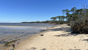
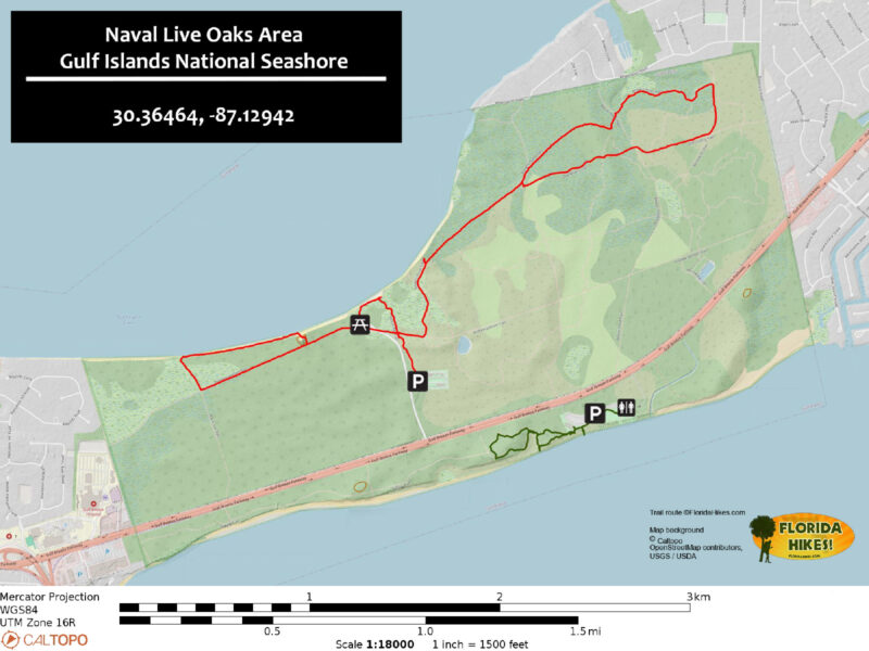
Off a backbone of the Andrew Jackson Trail, which runs the length of the preserve, the Naval Live Oaks trail network offers many options for loops.
As it turns out, what you see on posted maps isn’t what you get. There are additional well-worn cross trails through swaths of healthy coastal habitats.
 Coastal pine flatwoods on Pensacola Bay
Based on the advice of our friend Andy “Captain Blue” Niekamp, this 5.4 mile route we hiked with him and Denali includes the high points, both literally and for scenery.
There are potentially more miles to cover in the scrubby southeastern corner of the preserve, but it was recovering from a major fire on our visit.
 Tackling the trails together on a chilly morning
Resources





Disclosure: As authors and affiliates, we receive earnings when you buy through our links. This helps us provide public information on this website.
Overview
Location: Gulf Breeze
Length: 5.4 miles
Trailhead: 30.366163, -87.13913
Address: 1801 Gulf Breeze Parkway, Gulf Breeze
Fees: Free
Restroom: Across US 98 at the Santa Rosa Sound Area
Land manager: National Park Service
Phone: 850-934-2600
Open sunrise to sunset. Leashed dogs welcome but are not permitted on the bayside beach. If you bring a dog, skip the western loop of this hike by turning right when you first meet the Jackson Trail.
Bring adequate water and sun protection. Although there are tunnels of shade, the trails are largely in the open.
Cyclists are welcome on all trails on the bay side of Naval Live Oaks. You will encounter deep soft sand on some, particularly the Jackson Trail.
Directions
From downtown Pensacola, take US 98 east across the Pensacola Bay Bridge into Gulf Breeze. Continue another 1.4 miles past the Pensacola Beach Bridge turnoff into Naval Live Oaks Area. Watch for the turn-in on the left. Make a right off the entrance road into the parking lot adjoining the maintenance area. On occasion, the gate to the group camp may be open but trail users should park in the lot before the gate.
Hike
The North Bay Trail begins at the northeast corner of the parking area next to a kiosk with map.
Tunneling through a healthy coastal scrub, it’s an easy walk on hard-packed sand. Florida rosemary grows in sunny spots.
 Naval Live Oaks Trails trailhead
At 0.2 mile, emerge at an intersection with the Andrew Jackson Trail. It’s broad and has deep soft sand.
Turn left to follow it, emerging at the entrance road to the group camp, which has the elements of a day use area.
 Jackson Trail
Turn right and follow the pavement to where the Andrew Jackson Trail resumes on the opposite side of the road, adjoining the handicapped parking spot.
A picnic pavilion adjoins the large parking area, with restrooms beyond; we found them locked on a weekday and water shut off outside.
 Picnic pavilion at group camp
Pass a wooden gate and start a gradual but noticeable ascent along the Andrew Jackson Trail in the shade of the coastal scrub. If this feels like a road, it was.
It was the first Pensacola-St. Augustine Road, one of the earliest attempts to connect Florida’s two major cities when both were under Spanish rule.
A later version of the road went north of Pensacola Bay instead, with bricks still in place along a significant stretch east of Milton.
 Following in the footsteps of history
Reaching a summit in the ancient dunes, the old road continues downhill. A path comes in from the left at 0.6 mile.
Pass it by, following the Andrew Jackson Trail through a spill of dunes across the trail and a continued descent.
 Crossing the back side of a bayside sand dune
A “light at the end of the tunnel” effect occurs when sunlight spotlights the bright white sand surface of the path in the distance.
Exiting the tunnel of shade, walk through a sun-drenched coastal scrub. A mile into the hike, meet a trail intersection with the Boy Scout Trail.
 North end of the old Boy Scout Trail
Turn right to follow the slender singletrack through open scrubby flatwoods with patches of scrub palmetto.
The blue streak on the horizon beyond a showy row of slash pines is Pensacola Bay.
 Butcherpen Cove
At 1.1 miles, a stand of sand live oaks welcomes you to the beach of Butcherpen Cove along the bay’s southeast shoreline. Turn right to walk the beach.
Blue from a distance, the waters of Pensacola Bay are tannic up close. That’s thanks to the Escambia and Blackwater Rivers feeding this end of the bay.
 Start of the bayside beach walk
As you progress along the shoreline, so does the height and the pitch of the forested bluff, eroded in many places by past storms.
The Pensacola Bay Bridge sits on the far horizon, and you never know when the Blue Angels may zip past in formation.
Although these are brackish waters, alligators may lounge on this beach. Back way off if they don’t immediately jump in the water when they hear you.
 Hurricane-driven erosion keeps shrinking the beach
At 1.5 miles, reach a steeply pitched sand bluff with lots of footsteps in the deep sand. You won’t find another climb like this in Florida.
Use a hiking stick and aim diagonally for the crest, headed towards the massive oak on the left side of a sandy swale at the top.
 It’s a heart-pounding ascent for flatlanders
The last dozen feet are the toughest, but the view from up here is incredible. Take a break and savor it before following the adjacent pathway away from the bluffs.
You quickly reach the Andrew Jackson Trail. Turn left and continue downhill through a familiar shaded passage to the group camp.
 View from the climb
This time, follow the accessible sidewalk through what was the day use area towards the picnic tables near the bay.
Walk past the fire ring on a sand path to the beach. Turn right for a much briefer beach walk, this one showcasing the coastal pine flatwoods.
 Pathway to the beach
Strange dark lumps on the beach mirror those seen at Blackrock Beach on Big Talbot Island: organic matter remaining from the rootballs of washed-away pines.
These have become virtual “rocks” embedded in the sand.
 The lumps that look like rocks aren’t
On the approach to the curve of the cove there’s a furrowed cut to the right to a footpath. While it’s not marked, this is the North Bay Trail.
Exit the beach here, following the ribbon of well-trodden white sand through the breezy, open pine flatwoods.
 Retreating from the bay
The habitat quickly transitions to scrubby flatwoods before you meet a familiar intersection with the Andrew Jackson Trail from the opposite direction.
At 2 miles, this is a decision point: the parking area is straight ahead 0.2 miles if you want to shorten your hike. To stay on our longer route, make a left.
 Jackson Trail heading east
Walk the blinding white sands for a tenth of a mile to a welcome turnoff on the left that isn’t shown on the park maps.
This slender footpath slips into the scrub, showcasing large Florida rosemary under a low canopy of sand pines. There isn’t a lot of shade to start.
 The scrub path
Surrounding habitats shift between scrub and flatwoods and scrub before the trail enters a tunnel of sand live oaks.
A side trail at 2.4 miles tempts. It quickly emerges atop the bluffs with a furrowed sand ramp to water’s edge.
 A perch with a view
Past this overlook, enjoy a pleasant stroll in the dappled shade of the bluff forest for the next half mile.
Cross an unmarked sand road and continue into scrubby flatwoods and sand pine scrub. walking through a shady copse of magnolias.
 In the coastal hammock
Emerge onto an unmarked sand road, the Beaver Pond Trail, at 3.3 miles. Cross it at an angle to join the Brown’s Pond Trail.
This footpath runs along the south side of an unexpected find so close to Pensacola Bay: a floodplain forest perched on higher ground.
 Brown’s Pond
Reach a water-level spot with nice views across the pond, which has more open water on its upper end. From the drowned trees, we assume beavers created it.
Walk between clusters of saw palmetto on the shaded hillside above the pond. Past an enormous magnolia, the terrain gets more pronounced.
 Climbing away from the pond
Ascend to the junction with the Old Borrow Pit Trail at 3.7 miles. It’s unmistakable with its clever bench that can be transformed into a table and seat.
Make a right on the broad sand road and walk south through scrubby flatwoods for 0.2 mile.
 Transformer Bench
At a distinct junction by a large oak at an east-west sand road make a right onto the Old Quarry Pit Trail. Starting out very broad and churned up, this sand road remains in the sun.
It narrows as it draws closer to a clearly marked trail junction with Beaver Pond Trail at 4.1 mile. Continue straight ahead, gaining elevation.
 Rare trail junction sign
The path curves as it climbs over a sand ridge topped with pines. Trailside turkey oaks, signal sandhills although the understory is very dense.
Gently curving, the Old Quarry Pit Trail continues into scrubby flatwoods, a lone tall sand pine calling attention to itself.
 Old Quarry Pit Trail
At 4.5 miles, reach a north-south sand road. Cross it to complete the loop out to Brown’s Pond at a T intersection with the scrub footpath.
Turn left to retrace the pleasant walk through shady oak hammocks. Pass the side trail to the bay overlook at 4.9 miles.
 Coastal hammock near the overlook
Walk the white sand ribbon through the coastal flatwoods and scrub, emerging at the Andrew Jackson Trail at 5.2 miles.
Turn right and walk to the intersection with the North Bay Trail. Turn left to exit, reaching the parking area after 5.4 miles.
 Florida rosemary near the final trail junction
Trail Map
Explore More!
Learn more about Naval Live Oaks Area
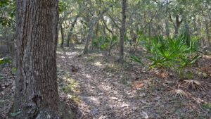 Naval Live Oaks Area Spanning from Santa Rosa Sound to Pensacola Bay, Naval Live Oaks Area is one of America's oldest federally protected forests, now part of Gulf Islands National Seashore.
Video
Hiking the Naval Live Oaks Trails
Slideshow
See our photos from this hike
Nearby Adventures
 Shoreline Park Explore a network of well-maintained and signposted nature trails threading through natural habitats atop bluffs and within wetlands along the shoreline of Santa Rosa Sound.
 Garcon Point Trail Pitcher plants and orchids accent expansive coastal prairie landscapes and diverse pine flatwoods along a series of trails at Garcon Point.
 Florida Trail, UWF/SRIA Dunes Preserve 3.2 miles. At the UWF/SRIA Dunes Preserve on Santa Rosa Island, the Florida Trail traverses a series of coastal habitats cradled by the sweeping dunes, providing a one-of-a-kind hike.
 Fort Pickens With more than seven miles of beaches along Santa Rosa Island, the Fort Pickens Unit at Gulf Islands National Seashore is a compelling destination at Pensacola Beach.

- Michael Crotty Bicentennial Park - November 3, 2026
- A.J. Henry Park - November 1, 2026
- Okeeheelee Nature Center Trails - October 22, 2026