
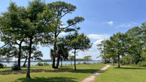
Established in 1945, Navy Point Linear Park protects nearly a third of the waterfront of Navy Point along Bayou Grande for a distance of almost 2.5 miles.
Neither end of the 2.3 mile paved path has trailhead parking, but there are several parks along the route, with Navy Point Park centrally situated off Sunset Blvd.
 A paved path parallels the shoreline of Bayou Grande in this city greenway
As this is a linear walk and the trailheads are central to the pathway, Navy Point Park makes a good anchor for a round-trip walk in either direction.
Although neither end of the trail has trailhead parking, both are marked by mileage 0.0/2.25 signs for walk-in from this historic residential community.
 Zero mile marker along Syrcle Drive
Developed as housing for Naval Air Station Pensacola, 700 homes were in place by the time a bridge was built to Navy Point in 1944. Many of those brick homes are still in place today.
With NAS Pensacola just across the bayou, expect to hear the roar of Navy jets coming into Forrest Sherman Field, home base for the Blue Angels demonstration team. Check their schedule online to take a hike while they practice.
 A low formation pass near Forrest Sherman Field
Resources





Disclosure: As authors and affiliates, we receive earnings when you buy these through our links. This helps us provide public information on this website.
Overview
Location: Pensacola
Length: 4.6 mile round-trip
Trailhead: 30.38171, -87.28342
Address: 400 NW Syrcle Dr, Pensacola
Fees: Free
Restroom: Portable toilets at two parks along the route
Land manager: Escambia County
Phone: 850-475-5220
Open sunrise to sunset.
Directions
From Interstate 10 exit 10 (US 29 / Pensacola Blvd) follow US 29 south for 1.4 miles to North W St. Turn right and drive 3.1 miles to W Fairfield Dr. Turn right and continue 1.2 miles, bearing left to follow New Warrington Spur. 2.9 miles later the road becomes Navy Blvd (SR 295). Continue another 1.1 miles towards NAS Pensacola to Sunset Ave. Turn right and cross the bridge. Make a immediate right . Navy Point Park is on the right.
Hike
Heading north from Navy Point Park, the path descends a bluff to the bayou, passing the first of numerous side loops. This one adjoins the bridge.
Turning to follow Bayou Grande upstream, walk beneath tall pines and scattered large oaks.
 Descending gently to the waterfront from the trailhead
The accessible asphalt path is within view of residences on Syrcle Dr but well below them on a strip of grassy waterfront.
Curve past a bench adjoining a chimney that might have been part of a picnic pavilion. Blue waters shimmer beyond palm fronds.
 Slope up towards the chimney
The day we visited, “Kate’s Pup Stop” was set under a tree, a cart with dog treats inside. Views open up along the waterfront near a bench under tall pines.
Pass the 2.0 mile marker. Curving and climbing, the pathway ascends past waterfront swings, reaching a water fountain before the crest.
 Two mile marker, as measured from the southern terminus
A loop branches off the main path to dip to bayou level past a bench. After they rejoin, walk by a large red channel marker embedded in the shoreline.
Walk beneath the pines, soaking in the views, before the trail splits again, forming a final loop down to the water’s edge at this end of the park.
 Passing the channel marker
Rejoining the main path, reach the 2.25 mile marker at the upper end of Navy Point Linear Park.
Return to Navy Point Park along the same pathway, taking the loops to slightly vary your hike and add a little mileage.
 One of several optional waterfront loops at this end
To walk to the other end of the park, head towards the memorial marker along Sunset Ave at Navy Point Park and cross Sunset Ave.
Follow the sidewalk and then the asphalt path around the big boat launch parking area. It resumes following the waterfront on a narrow strip adjacent to a residential circle.
 Sign adjoining Sunset Avenue crossing
The path broadens as it leaves the bayou behind. Continue around a creek flowing into the bayou, staying close to the road briefly before descending through a gentle sandhill.
Reach a point along Bayou Grande where the bridge to NAS Pensacola is a prominent feature on the far side of the water.
 Looking back at the bridge at a circle at a curve
Posts separate the path from the road, as the park strip is narrow along this side of the point. Benches sit in the shade of gnarled sand live oaks along the waterfront.
Loop around a marshy cove, the path adjoining the road briefly to cross a creek. At the 0.5 mile marker, the park broadens significantly, an urban forest of pines and oaks.
 Forest along the bayou
A bench overlooks a beauty spot across the bayou, a passive recreation area on the station. Edging the road for another creek crossing, the path passes beneath towering pines.
Walk along the waterfront past a shoreline restoration area with a slender white sand beach.
 Shoreline of Bayou Grande
Meet the third developed area along the linear park, Navy Point Playground. It has a playground and picnic area in a sand live oak hammock.
There are several parking spaces adjoining it and usually a portable toilet in place.
 Navy Point Playground
A quarter mile from the end, the park broadens again, with a diverging loop out to a point with a view of the far wooded shoreline of NAS Pensacola.
The paths come together and the main path curves towards the road, edging it up to the 0.0 / 2.25 marker at this end of the park.
 Turn around at the south end of the pathway
Turn around here and walk back to Navy Point Park to complete this second round-trip for a 4.6 mile walk.
 The last side loop at the south end is a beauty
Trail Map

Explore More!
Video
Slideshow
See our photos of Navy Point Linear Park
Nearby Adventures
More worth exploring nearby
 Fort Barrancas Part of the Third System of coastal defenses built in the 1840s by the Army Corps of Engineers, Fort Barrancas is the showy centerpiece of a National Park unit inside Naval Air Station Pensacola.
 Edward Ball Nature Trail Circle the Thompson Creek floodplain beneath the shade of tall cypresses on this nature trail loop on the edge of the University of West Florida campus.
 Tarkiln Bayou Preserve State Park Conserving a vast swath of wetland habitats in low-lying areas along the Perdido River floodplain, Tarkiln Bayou Preserve State Park is home to four species of Sarracenia - pitcher plants - unique to the Gulf Coast.
 Garcon Bayou Nature Park On 18 acres along Garcon Bayou, a boardwalk with freshwater wetland and brackish bayou views attracts birders to a small nature park with picnic pavilions and playgrounds.

- Fort Matanzas National Monument - November 21, 2026
- Carney Island Conservation Area - November 19, 2026
- Hal Scott Red Trail - November 13, 2026