

Defining the north shore of Biscayne Bay, the sweep of beach at Oleta River State Park is unlike any other in the Miami metro.
Buffered by a thousand acres of park, with a backdrop of mangrove forest, its gentle waters stand in sharp contrast to the nearby Atlantic beaches edged by condo canyons.
 The beach at Oleta River
But the beach isn’t all this park offers. With its long ribbon of waterfront, the park attracts a regular parade of paddlers down its mangrove channels and across the bay.
Renowned for its extensive and challenging mountain bike trails, Oleta River State Park is also a prime destination for off-road cyclists in South Florida.
 A cyclist pauses for a partner to catch up
Resources



Disclosure: As authors and affiliates, we receive earnings when you buy these through our links. This helps us provide public information on this website.
Overview
Length: 18.3 miles of paved and unpaved trails
Trailhead: 25.927867,-80.136234
Address: 3400 NE 163rd St, North Miami Beach
Fees: $6 per vehicle
Restroom: At the picnic areas, beach, and outdoor center
Land manager: Florida State Parks
Phone: 786-756-2327
Open 8 AM to sunset. Leashed dogs welcome but not on beach.
When the park reaches capacity, which it often does on weekends, it will not reopen to visitors until the next day.
Directions
From the interchange tangle of Interstate 95 at Florida’s Turnpike in Golden Glades north of Miami, take NE 163rd St east for 3.6 miles to US 1. At the northwest corner of the park, Blue Marlin is 0.2 mile east of US 1 on the south side of Sunny Isles Blvd. The main entrance to Oleta River State Park is along Sunny Isles Blvd, 1.1 miles east of US 1 and 0.9 mile west of A1A.
About the Park
Despite its urban setting, Oleta River State Park is all about the outdoors. It protects the last remaining natural river emptying into Biscayne Bay.
Like other waterways along this coast, it rose from the Everglades. All others have been dredged or turned into canals, despite their natural beauty.
 The Oleta River meets Biscayne Bay
As the Oleta River completes its journey towards the Atlantic Ocean, it disperses through the last remaining mature mangrove forest within view of downtown Miami.
From Blue Marlin, a lesser-known corner of the park with a restaurant and separate entrance on the causeway to Sunny Isles, statuesque white mangroves tower over the river’s flow.
 Red and white mangroves line the Oleta River
This vast mangrove swamp makes up nearly half of the park. A large portion of it is visible as you cross the causeway to Sunny Isles Beach.
You’ll encounter mangrove-lined channels it not just while paddling but also edging the paved loop central to the park.
 Dense walls of mangroves are ubiquitous throughout the park
A tiny touch of tropical hammock graces the tip of the park’s peninsula into the bay, with a short interpretive nature trail tunneling through it.
The paved pathways linking key park features are edged by sea grape and buttonwoods behind the mangrove frontage.
 Pathway near the beach
But in some portions of the park, natural habitats are spotty. Invasive Australian pines towered from rocky fill established long before the state acquired this land.
The pine forest’s rugged terrain was put to use for the bike trail system. Efforts are now underway to remove the pines and restore the uplands of the park to coastal hammock.
 The off-road trails are neither flat nor straight
The beach is a short walk from the large parking area, and the main picnic area edges the waterfront facing Sunny Isles Beach and Haulover Park.
Several sizes of pavilions can be rented, and there are scattered picnic tables for causal use.
 Busy picnic pavilion along the waterfront
Beyond the beach is a popular fishing pier, and quiet natural coves edging the peninsula, for your own sweep of sand to plop down a beach chair.
The Friends of Oleta State Park, providing volunteer support for the entire park, established a butterfly garden along the paved loop too.
 Butterfly garden
Paddling
Watersports activities mainly radiate from the Oleta River Outdoor Center at the north end of the parking lot.
Alternatively, check in at Blue Marlin along the causeway for kayak and paddleboard rentals and tours in the upper river, as well as seafood with an Oleta River view.
 Boardwalk at Blue Marlin
The inviting expanse of Biscayne Bay makes paddling a primary activity at Oleta River State Park.
Bring your own paddleboard or kayak, or grab a rental from the outfitters. The launch inside the park is directly across from Oleta River Outdoor Center.
 Paddlers heading for Biscayne Bay
Oleta River flows into the bay through a puzzle of mangrove forest which you’ll need to navigate from the launch.
The paddling trail goes through a pipe under a park road, emerging along the north shore of the bay.
 The park beach as seen from a kayak
The park protects a cove within the bay, but it is breezy. Once on open water, the wind can be a challenge.
It’s critical to keep an eye on the skies for changes in the weather, especially if you’re exiting to the broader expanse of Biscayne Bay.
 Paddleboarder making headway
Sandspur Island separates an inner channel from busy Haulover Inlet and its navigational channel.
Paddlers will find smoother water on the west side of the island to reach a pretty cove along a smaller island to its immediate south.
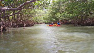 Kayaking Oleta River State Park Paddling within sight of downtown Miami? Kayak or SUP from Blue Moon Outdoor Center in Oleta River State Park to explore mangrove shorelines along Biscayne Bay
 John paddling in the mangroves
Biking
More than three miles of paved trail extend from the park entrance along the entrance road, proving access to the tip of the peninsula.
Along this path are the paddlesports area, beach, and picnic area. The paved path also interconnects directly with two short offroad trails.
 Offroad trail near the beach
These are good “dip your toe in” trials for the much more challenging array of trails on the west side of the park.
Built to challenge mountain bikes, 15 miles of twisting, winding singletrack wend through wooded landscapes.
 Singletrack through mangroves
Level trails explore the edges of the mangrove forest, while The hillier routes go through the Australian pine forest.
Other than the two short ones near the beach, the off-road singletracks are accessed via the unpaved park road leading to the cabins.
 Trails are marked for one way travel
Camping
A charming set of fourteen camping cabins are set centrally in the park, away from the bustle of beachgoers and the water sports area.
Small but air conditioned, they sit on their own private peninsula in the mangrove forest, with easy access to the off-road trail system.
 Part of the cabin circle
Each rustic cabin comes with a picnic bench and grill and has a small porch. You must bring your own linens. They do not have bathrooms but a bathhouse is centrally located.
A rare treat in this urban area, the cabins are popular. One is ADA accessible. Rentals are $55 per night plus a Reserve America reservation fee. A two night minimum is required.
 The cozy cabins are for “roughing it”
Organized youth groups can also contact the park to utilize one of the three primitive campsites.
Each campsite has a central restroom, fire circle, and picnic tables. Call the park directly at 305-919-1844 to arrange a stay.
 The nature trail was built as an Eagle Scout project
Hiking
From the parking area closest to the beach, the paved path from the parking area provides an easy loop of a little more than a mile.
Start by walking towards the pier, loop around the peninsula to the picnic area, and do a second loop around the playground and beachfront.
 View of beach and pier from the paved path
Branching off that loop, South Point Nature Trail is a short interpretive trail that tunnels into the coastal hammock.
It’s a linear quarter mile partly under a canopy of trees, making for a half mile loop if you pair it with the path it touches at two points.
 South Point Nature Trail
A walk on the paved path from the picnic area facing Haulover Beach up to the park entrance gate and back is 3 miles.
It’s worth it for morning or evening exercise, but is almost entirely in full sun and sometimes busy with cyclists.
 Paved path paralleling the park road
Trail Map

Explore More!
Slideshow
See our photos of Oleta River State Park
Nearby Adventures
More worth exploring while you’re in this area.
 Arch Creek Park An oasis of natural tropical hammock in North Miami, Arch Creek Park hugs the eastern edge of its namesake creek, which once had a natural limestone bridge used by indigenous peoples and pioneers.
 Matheson Hammock Park A tropical retreat along the coast of Coral Gables, Matheson Hammock Park has two distinct sides: a wild slice of the ancient Miami Hammock and a waterfront with a man-made atoll on Biscayne Bay.
 Bear Cut Preserve On the northern end of Key Biscayne, a set of sandy and paved trails lead out to a boardwalk overlooking fossilized coral reefs and downtown Miami in the distance.
 Cape Florida State Park A popular destination for sun worshipers, Bill Baggs Cape Florida State Park has a long strand of beachfront complimenting trails along Biscayne Bay and a historic lighthouse at the point.

- Hal Scott Yellow Trail - November 3, 2026
- Hal Scott Preserve - October 28, 2026
- Tradewinds Park - October 27, 2026