• Skip to main content
  • Skip to header right navigation
  • Skip to after header navigation
  • Skip to site footer
Florida Hikes logo

Florida Hikes

Hike Bike Paddle Camp Florida with authors Sandra Friend and John Keatley as your guides

  • Trails
  • Maps
  • Guidebooks
  • Hike
    • Scenic Hikes
    • Loop Trails
    • Dog-friendly Hikes
    • Hikes for Kids
    • National Parks in Florida
    • Florida State Parks
  • Bike
    • Major Bike Trails
    • Paved Bike Trails
    • Off Road Biking
    • Biking Articles
  • Paddle
    • Canoe & Kayak Rentals
    • Paddling Destinations
    • Paddling Articles
  • Camp
    • Cabin Rentals
    • Car Camping
    • Primitive Camping
  • Florida Trail
    • Plan your Hike
    • Best Scenic Hikes
    • Best Backpacking
    • Section Hiking
    • Thru-Hiking
    • Trail Updates
  • Travel
Forest canopy shading broad forest road

St. Lucie Lock and Dam

At a complex spanning the St. Lucie Lock and Dam, a yellow blazed loop trail winds north through a shady palm hammock carpeted with ferns and wild coffee.

Stuart (27.110889, -80.284611)   1.0 miles  

Built in 1941 by the Army Corps of Engineers, the St. Lucie Lock was constructed for flood control, replacing the natural outflow of the St. Lucie River from Lake Okeechobee.

This waterway is now part of a cross-Florida navigational route connecting the Atlantic Ocean to Lake Okeechobee and on to the Gulf of Mexico.

Canal with boaters The St. Lucie Canal


Adjoining the lock, the St. Lucie South Recreation Area provides picnic tables, fishing piers, a boat ramp, and campground.

On the north side of the lock, the St. Lucie Nature Trail winds through a subtropical forest next to a primitive group campsite.

Yellow blazed Trail Nature Trail


Resources

Resources for exploring the area
Florida Trail Hikes book cover The Florida Trail Guide book cover South Florida Explorers Guide book cover 50 Hikes in South Florida book cover Hikers Guide to the Sunshine State book cover Paddlers Guide Florida
 
Disclosure: As authors and affiliates, we receive earnings when you buy through our links. This helps us provide public information on this website.

Overview

Location: Stuart
Length: 1 mile lollipop
Trailhead: 27.110889, -80.284611
Address: 2200 SW Canal St, Stuart
Fees: Free
Restrooms: Restroom at visitor center, privy on north side of lock
Land manager: Army Corps of Engineers
Phone: 772-219-4575

Open 7 AM to 4:30 PM. Visitor center open 9 AM to 4 PM during the winter season. Leashed pets welcome. No charge for boat ramp use.

Campsites ($25-30 per night) at the St. Lucie South campground accommodate both trailer and tent camping, plus boater campsites. Restrooms, shower, and dump station provided. Call 772-287-1382 for campsite information.


Directions


From the Interstate 95 exit for SR 76 (Kanner Hwy) in Stuart, follow SR 76 west for a half mile. Turn right on SW Locks Rd. In 1.3 miles, turn left onto Canal St. The parking area is on the right side of the road.

Hike

Before starting the hike, check out the visitor’s center east of the lock to pick up a paper trail map and learn more about the site.

The center has helpful volunteers and dozens of colorful displays describing the history of the lock and the local ecology.

Small government building Visitor Center


Starting at the parking area, take a short stroll on the sidewalk towards the dam complex, passing a grassy area with covered picnic tables and benches.

Turn left at a tall chain link fence gate and head towards the lock as the sound of rushing water gradually increases.

Gate in fence to Lock Entrance gate


A large kiosk alongside the lock describes the history and function of the Okeechobee Waterway, and information about the Lake Okeechobee Scenic Trail.

If the lock is not in operation, a prominent yellow gate should be open, allowing visitors to cross. When in use, a loud bell sounds as the yellow gate closes mechanically.

Across the lock, an obvious walkway flanked by fences leads across the dam to the northern recreation area.

Lock crossing Crossing the lock


Crossing a short bridge over a spillway for Hog Creek, look for the trailhead sign to the left alongside a stand of cabbage palms.

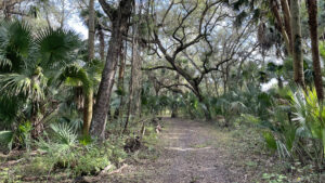
Following a wide pathway of mowed grass, the trail enters a deeply shaded hardwood hammock.

Nature trail sign Trailhead


A mix of ferns and wild coffee cluster alongside the trail under heavy, arched limbs of live oaks covered with air plants and Spanish moss.

Large vines hang from the canopy, strung between branches or drooping to the forest floor.

Broad path under oaks Shady hammock


Reaching a half mile, the path opens to a sandy clearing with a covered bench.

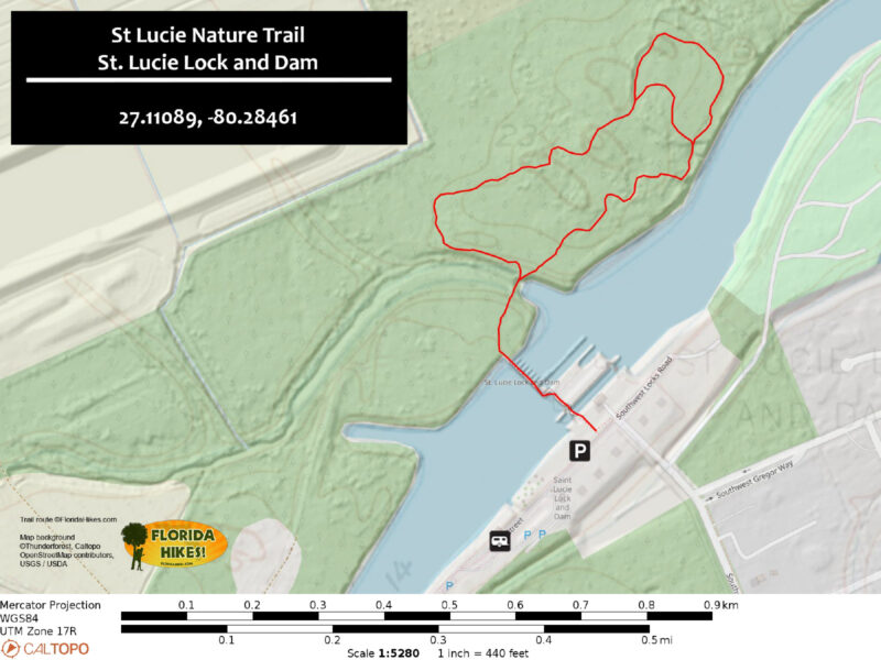
Following yellow blazes east, turn right where the trail forks to take a windy route to the south end of the loop.

Although this shortens the hike, the longer loop is rife with invasive plants and their clingy seed pods.

Clearing with bench Covered bench


Curving back towards the lock, the trail descends a set of stairs, passing an impressive strangler fig and views of the water through the trees.

Reaching the trail’s end, the pathway opens to a wide grassy field where covered benches surround a fire ring for the group campground.

Continue across Hog Creek and the lock, returning to the entrance gate in a quarter mile.

Campsite with benches Group camping area


Trail Map

St. Lucie Nature Trail Map


Explore More!

Video

A walk through the St. Lucie Nature Trail


Slideshow

See our photos from the St. Lucie Lock and Dam


Nearby Adventures

Halpatiokee river platform Halpatiokee Regional Park Beyond its prominent ballfields, Halpatiokee Regional Park hides a rich network of hiking, off-road biking, and paddling trails along the South Fork of the St. Lucie River.
Broad sand road through sandhill habitat Atlantic Ridge Preserve State Park Protecting what remains of the forested Atlantic Ridge between the Indian River and the St. Lucie River, this secluded state park is hidden behind subdivisions in Stuart.
White path through pine woods with dense understory Delaplane Preserve An easy trail through pine flatwoods and mangrove marsh leads to an overlook at the confluence of waterways.
Marshy pond rimmed with pines Kiplinger Preserve Tunnel through mangroves after pausing to watch birds in a freshwater wetland in this habitat-rich preserve along the St. Lucie River.

Reserve Campsite Official Website

  • Author
  • Recent Posts
Chris Stevens
Chris Stevens
Along with his wife Chelsey, Chris Stevens shares outdoor adventures on Instagram and Facebook as @sunshinestateseekers and is a co-host of a podcast about Florida's outdoors, The Florida Madcaps. An avid hiker and camper, Chris serves as a Trailmaster and a board member for the Florida Trail Association.
Chris Stevens
Latest posts by Chris Stevens (see all)
  • Calusa Heritage Trail - November 5, 2026
  • Scherer Thaxton Preserve - October 21, 2026
  • Little Awesome Preserve - October 19, 2026
Category: Army Corps of Engineers, Camping, Day Hikes, Hikes, Loop Hikes, TrailsTag: Boating, Car Camping, Developed Camping, Group Camping, Palm City, St. Lucie River, Stuart

Sidebar

FarOut Guides

Our comprehensive trail logistics presented on offline maps:

Florida National Scenic Trail (1,500 miles)
Florida Keys Overseas Heritage Trail (108 miles)
Eastern Continental Trail in Florida (92 miles)


We earn a small commission on sales through these links. Thanks for your support!


Our Guidebooks

We’ve written Florida guidebooks for over 25 years. These include Southeast Florida destinations.

Book cover with woman hiking through palms with baby carrier
Book cover of Florida Trail Hikes
The Florida Trail Guide fifth edition

Explore More

Newest Articles for Southeast Florida

Emerging from a tunnel of trees to a waterfront Tradewinds Park
Bench at a junction of trails in pine-palm flatwoods Okeeheelee Nature Center Trails
Dense understory beneath pines along footpath Lakewood Regional Park
Silvery-blue saw palmetto Lantana Scrub Natural Area

  • Facebook
  • Flickr
  • Instagram
  • Pinterest
  • Substack
  • Vimeo

FIND A TRAIL OR PARK

METROS: Bradenton. Clearwater. Crestview. Daytona Beach. Destin. Fort Lauderdale. Fort Myers. Fort Walton Beach. Gainesville. Jacksonville. Kissimmee. Lakeland. Melbourne. Miami. Naples. Ocala. Orlando. Panama City Beach. Pensacola. Port St. Lucie. Punta Gorda. St. Petersburg. Sanford. Sarasota. Sebring. Stuart. Tallahassee. Tampa. Vero Beach. West Palm Beach.

MULTI-REGION: Atlantic Coastal Ridge. Atlantic Coast. Bartram Trail. Big Bend. East Coast Greenway. Everglades National Park. Florida National Scenic Trail. Gulf Coast. Lake Wales Ridge. WATERWAYS: Indian River Lagoon. Intracoastal Waterway. Kissimmee River. St. Johns River. Withlacoochee River.

NORTHWEST FLORIDA: Altha. Apalachicola. Apalachicola National Forest. Big Bend Scenic Byway. Blackwater River State Forest. Blountstown. Bonifay. Bristol. Bruce. Cantonment. Cape San Blas. Carrabelle. Chattahoochee. Chipley. Crawfordville. DeFuniak Springs. Eastpoint. Ebro. Eglin Air Force Base. Freeport. Fountain. Gulf Breeze. Gulf Islands National Seashore. Holt. Madison. Marianna. Milton. Monticello. Mossy Head. Munson. Navarre. Navarre Beach. Newport. Niceville. Panacea. Panama City . Perdido Key. Ponce De Leon. Port St. Joe. Quincy. Santa Rosa Beach. Sopchoppy. South Walton. St. George Island. St. Marks. St. Marks NWR. Sumatra. Vernon. Wakulla. Wewahitchka. Woodville. WATERWAYS: Apalachicola River. Blackwater Bay. Blackwater River. Chipola River. Choctawhatchee Bay. Choctawhatchee River. Coastal Dune Lakes. Ochlockonee Bay. Perdido River. St. Marks River. Wacissa River. Wakulla River. Yellow River.

NORTH FLORIDA: Alachua. Amelia Island. Archer. Baldwin. Branford. Bronson. Bunnell. Callahan. Cedar Key. Chiefland. Crescent City. Cross City. Cross Creek. Dowling Park. Ellaville. Fanning Springs. Fernandina Beach. Flagler Beach. Fort White. Glen St. Mary. Green Cove Springs. Hawthorne. High Springs. Inglis. Jacksonville Beaches. Jacksonville Northshore. Jasper. Jennings. Keystone Heights. Lake Butler. Lake City. Live Oak.Macclenny. Mandarin. Mayo. Mayport. Micanopy. Middleburg. Old Town. Olustee. Orange Park. Osceola National Forest. Palatka. Palatka-Lake Butler Trail. Palm Coast. Palm Valley. Perry. Ponte Vedra. Rodman. Salt Springs. St. Augustine. Starke. Steinhatchee. Suwannee. Suwannee River Wilderness Trail. Suwannee Springs. Talbot Islands. Timucuan Preserve. Trenton. Waldo. Welaka. White Springs. Williston. Worthington Springs. Yankeetown. WATERWAYS: Santa Fe River. St. Marys River. Suwannee River. Tolomato River. Upper Withlacoochee River.

CENTRAL FLORIDA: Altamonte Springs. Apollo Beach. Apopka. Astatula. Astor. Auburndale. Bartow. Babson Park. Bayport. Belleview. Bithlo. Brandon. Brooksville. Bushnell. Canaveral National Seashore. Cassadaga. Christmas. Chuluota. Citrus Springs. Clearwater Beach. Clermont. Coast to Coast Trail. Cocoa. Cocoa Beach. Cross Florida Greenway. Crystal River. Dade City. De Leon Springs. DeBary. Deland. Deltona. Dunedin. Dunnellon. Edgewater. Enterprise. Eustis. Ferndale. Fort Meade. Frostproof. Geneva. Gibsonton. Haines City. Hernando. Hernando Beach. Holopaw. Homosassa. Inverness. Kenansville. Kissimmee. Lake Mary. Lake Wales. Largo. Leesburg. Lithia. Longwood. Lutz. Maitland. Malabar. McIntosh. Melbourne Beach. Merritt Island. Merritt Island NWR. Mims. Mount Dora. Narcoossee/Lake Nona. New Port Richey. New Smyrna Beach. Nobleton. Oak Hill. Oakland. Ocala National Forest. Ocklawaha. Ocoee. Oldsmar. Orange City. Ormond Beach. Osteen. Oviedo. Paisley. Palm Bay. Plant City. Poinciana. Polk City. Ponce Inlet. Port Orange. Ridge Manor. Riverview. Ruskin. Safety Harbor. Silver Springs. Sorrento. Spring Hill. St. Cloud. Tarpon Springs. Thonotosassa. Titusville . Umatilla. Viera. Walt Disney World. Weeki Wachee. Weirsdale. Wimauma. Windermere. Winter Garden. Winter Haven. Winter Park. Winter Springs. Withlacoochee State Forest. Withlacoochee State Trail. Yeehaw Junction. Zephyrhills. WATERWAYS: Alafia River. Halifax River. Hillsborough River. Lake Apopka. Little Manatee River. Ochlawaha River. Rainbow River. Tampa Bay. Wekiva River. Wekiva River Basin.

SOUTHWEST FLORIDA: Alva. Boca Grande. Cape Coral. Charlotte Harbor. Ding Darling NWR. Ellenton. Englewood. Estero. Immokalee. Marco Island. North Port. Osprey. Palma Sola. Palmetto. Pine Island. Port Charlotte. Sanibel Island. Venice. WATERWAYS: Caloosahatchee River. Manatee River. Myakka River. Pine Island Sound.

SOUTH FLORIDA: Arcadia. Basinger. Big Cypress National Preserve. Big Cypress Seminole Reservation. Big Cypress Swamp. Bowling Green. Clewiston. Everglades City. Indiantown. LaBelle. Lake Okeechobee Scenic Trail. Lake Placid. Lakeport. Moore Haven. Okeechobee. Ortona. Pahokee. Palmdale. Port Mayaca. South Bay. Wauchula. Zolfo Springs. WATERWAYS: Fisheating Creek. Lake Okeechobee. Peace River.

SOUTHEAST FLORIDA: Biscayne Bay. Biscayne National Park. Boca Raton. Boynton Beach. Coconut Creek. Coral Gables. Coral Springs. Davie. Delray Beach. Fellsmere. Flamingo. Fort Pierce. Hobe Sound. Hollywood. Homestead. Indrio. Jensen Beach. Juno Beach. Jupiter. Jupiter Farms. Key Biscayne. North Hutchison Island. Ocean to Lake Greenway. Palm Beach. Palm Beach Gardens. Pompano Beach. Redland. Sebastian. South Hutchinson Island. WATERWAYS: Florida Bay. St. Lucie River.

FLORIDA KEYS: Big Pine Key. Islamorada. Key Largo. Key West. Marathon. Overseas Heritage Trail.


©2006-2026, Sandra Friend & John Keatley | Disclosure | Site Index | Work with Us | Advertise with Us | Terms of Service and Privacy Policy

Florida Hikes PO Box 93 Mims FL 32754 | Contact