
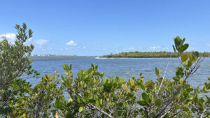
Encompassing Rocky Point at the tip of Port Salerno, Twin Rivers Park lays out a feast for the eyes from its waterfront boardwalks.
While designated fishing piers, they make a compelling destination for the panorama of water and islands where St. Lucie River and the Indian River Lagoon meet near St. Lucie Inlet.
 Overlooking St. Lucie Inlet
Resources





Disclosure: As authors and affiliates, we receive earnings when you buy through our links. This helps us provide public information on this website.
Overview
Location: Port Salerno
Length: 0.5 mile
Trailhead: 27.163788, -80.181936
Address: 3505 Kubin Ave, Stuart
Fees: Free
Restroom: Adjoining the parking area
Land Manager: Martin County
Phone: 772-221-1418
Open 7 AM to 9 PM. Leashed dogs welcome; pick up after your pet. No glass containers allowed in park.
No bicycles or bare feet on the boardwalks. Diving, swimming, or cast netting is also prohibited.
Directions
From Interstate 95, exit at SR 76 (Kanner Hwy) and head east for a half mile, turning right onto Cove Rd. Continue 4.5 miles, passing straight through a traffic circle to reach Manatee Cove Rd. Turn left. Drive 0.4 mile and make a right on Horseshoe Point Rd. Continue 0.8 mile to Kubin Ave. Turn left and drive 0.9 mile to the park entrance on the right.
Hike
Paved trails extend in two directions towards the waterfront from the parking circle. Take the one to the right, which has a branch to the restrooms. Both paths rejoin.
Descend very gradually, paralleling a decorative fence separating the landscaped portion of the park from the natural coastal hammock.
 Looking back up the descent
Benches and a picnic pavilion enjoy the shade of large sea grapes before the path curves past a pretty view of the north tip of Jupiter Island on the far side of the Indian River Lagoon.
This end of the island is protected by St. Lucie Inlet Preserve State Park. A sweep of natural sand beach is on this side of the lagoon.
 Natural waterfront
The first boardwalk begins to the right. As it turns, it expands this view to encompass St. Lucie Inlet itself, the Atlantic Ocean the horizon between barrier islands.
The populated north side of the inlet is the southern tip of South Hutchinson Island, not far from Bathtub Beach and the House of Refuge.
 Expanse of water where waterways meet
Boats zip in and out of the channel as well as across it, a dizzying array on weekends. PVC pipes provide places for anglers to station a fishing pole and drop a line.
You may find folks fishing anywhere along this designated fishing pier. A wide spot in the deck has benches.
 The first broad boardwalk
Making a turn, the boardwalk enters a touch of coastal hammock along the waterfront, with nickerbean spilling across buttonwoods and mangroves.
Turn right to walk along the pavers to the second boardwalk, which begins around a quarter mile. Gumbo-limbo and cabbage palms face the open grassy hillside of the park.
 Start of the second boardwalk
Emerging from the mangroves into full sun, pass a pair of benches with a view north behind them.
Sewall’s Point is the near land mass with the bridge crossing to Hutchinson Island.
 View towards Sewalls Point
The marked channel up the St. Lucie River isn’t far offshore, so boat traffic can be pretty steady here.
We witnessed a near miss, a powerboat unaware that a pontoon driver was trying to “ride the waves” of every passing boat, endangering everyone.
 Boats whipping past the boardwalk
Before the boardwalk turns back to shore, birders, keep watching the skies; it’s not just osprey up there. Bald eagles were scouting the area, too.
At water level, expect the usual herons and egrets. Our most unexpected wildlife sighting was an iguana more than two feet long, unafraid of passerby.
 Iguana on a fencepost
After the boardwalk reaches the shore, continue along the path behind the seawall for more views across these ever-changing waters.
Like the path down to the waterfront, it does the same in reverse, slowly climbing the hill against a ribbon of preserved coastal hammock. Return to the parking area by a half mile.
 Return route to the scenic hill climb
To extend your walk to a mile or more, continue around the parking circle. For cyclist access to the waterfront, a 0.4 mile linear paved path parallels the park road.
It winds along the coastal hammock to the park entrance off Kubin Ave. Views are the same as the road, but there’s more shade.
 Side path along the park road
Trail Map

Explore More!
Video
A walk through Twin Rivers Park
Slideshow
See our photos from Twin Rivers Park
Nearby Adventures
 St. Lucie Inlet Preserve State Park A state park only reachable by water, St. Lucie Inlet Preserve occupies the northern tip of Jupiter Island, quiet beaches and mangrove forests defining its shores.
 Maggy’s Hammock Park Formerly known as Rocky Point Hammock, Maggy’s Hammock Park protects 22 acres of lush tropical forest and scrub on the Atlantic Coastal Ridge in Port Salerno.
 Seabranch Preserve State Park Find a wonderland of white sand and small shrubs at Seabranch Preserve State Park, which protects a sand pine scrub and more along the Atlantic Coastal Ridge.
 Gomez Preserve Purchased to protect the footprint of an early 1900s settlement along the Indian River Lagoon, Gomez Preserve is one of the lesser-known hiking destinations in Hobe Sound.

- Michael Crotty Bicentennial Park - November 3, 2026
- A.J. Henry Park - November 1, 2026
- Okeeheelee Nature Center Trails - October 22, 2026