
NOTE: As of 4/2026, work is underway to replace bridges on the Springs Trail so expect closures.
Protecting an unusual collection of salt springs and the estuary they nourish, Werner-Boyce Salt Springs State Park hides in plain sight.
It’s a long, linear park along the Gulf of Mexico, a buffer between open water and crush of commerce and residential communities along US 19 in Port Richey.
The park has three trailheads at three different locations. The longest and showiest of the trails, the Springs Trail begins at the main entrance parking area.
 Waterfront along Salt Springs Creek
Along its trail network, geologic oddities abound, including some of Florida’s deepest springs and an unusual tidal waterfall.
Well-marked and well-maintained, with panoramas of salt marshes and fabulous birding, the Springs Trail is a delight to hike.
 Some of the smaller named springs along the trail
Resources





Disclosure: As authors and affiliates, we receive earnings when you buy through our links. This helps us provide public information on this website.
Overview
Location: New Port Richey
Length: 1.6 miles
Trailhead: 28.28854, -82.71848
Address: 8737 US 19 N, Port Richey
Fees: $4 per vehicle
Restroom: Near the trailhead
Land Manager: Florida State Parks
Phone: 727-816-1890
Open 8 AM to sunset. Leashed dogs welcome. Some parts of the trail system flood at high tide.
There is a boardwalk to the coastline and kayak launch past the restrooms, and a separate trailhead for the Eagle Trail across the parking area.
Directions
From Interstate 75 exit 285, San Antonio, follow SR 52 west for 23 miles to reach US 19. Alternatively, use the Suncoast Parkway from Tampa to exit at SR 52. Turn south on US 19 off SR 52 and continue 3.4 miles to the prominent main entrance to the park. Turn right and follow the park entrance road a half mile to the parking area.
Hike
Starting at the edge of the woods behind the trail kiosk and entrance road, a sign with mileages to each of the geologic features points out what you’ll see along this trail system.
The springs on this coastline are brackish to saline, their flow tidally influenced. Geologists estimate they formed when the shoreline of the Gulf was seventy miles farther west.
 Entry sign listing springs
The underlying limestone bedrock continues to erode. The last time we saw Toilet Bowl Spring, it was small and swirly. It’s still listed on the sign, but no longer viewable.
A collapse of the karst around it forced the park to close the picnic area that adjoined it. A new viewing platform is in place.
 Toilet Bowl Spring in 2017
It’s easy to walk right past Cauldron Spring without noticing it. Emerging from under a rocky bluff into the waterway under the bridge, it has limestone “teeth.”
Stalactities and stalagmites guard the passageway cave divers have entered to map it to 320 feet deep. The sign for it is on the bluff by a trail junction.
 Cauldron Spring
While a Springs Trail sign points left, continue straight ahead for our figure-8 route. Pass by an unposted side trail on the right used as a fire line.
Walk through the healthy flatwoods to the next right turn, a signposted spur trail leading to Reflection Spring.
 Pine flatwoods
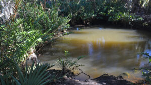
Reflection Spring is a beauty, a tannic but clear pool in a basin surrounded by a palm hammock. A bench overlooks it.
This spring emerged after rangers removed a ton-and-a-half log from what they thought was a marsh among the ponds.
Illuminated from above, tiny fish swim through the water, illustrating the connectivity of this spring with the larger salt marsh.
 Reflection Spring
Return to the main trail and turn right. Up ahead, a T junction at a quarter mile has signage and a bench.
Turn right to start the trek to Salt Spring and its tidal waterfall. Make a left at the junction with the Fire Line Trail, where a bench faces a kiosk.
 Trail junction
Depending on the tides and recent rains, the traverse on the edge of the salt marsh may be muddy.
Rising out of the basin, pass the entrance to Cypress Oak Pass on the right. Salt Spring is straight ahead, also marked with a sign.
 The pathway crosses the salt marsh
There is very little disturbance to the water’s surface, which stretches well beyond the spring into a large salt pond.
The trail follows the almost impercetible flow of the spring run downstream.
 Salt Spring
Where the waterway narrows and enters a tunnel of mangroves, a sign points out the Tidal Waterfall.
This short path only provides a peek at ripples in the run seen through the mangrove leaves.
 Tidal waterfall
A better view is along the bluff across from the salt-making interpretive display. The volume and speed of water varies with the tides.
Follow a short loop around this peninsula in the mangroves, where a portable observation deck is often set up for birders.
 Observation deck
Loop back past the salt-making display, which features an oven and kettle of the type actually used in this location more than a century ago.
A commercial operation boiled the water from the stream off to leave a coating of salt to scrape off for sale.
 Part of the salt-making display
Returning past Salt Spring a half mile into the hike, make a left on Cypress Oak Pass.
Wriggling through a palm hammock along the mangrove-lined salt pond, this scenic path provides occasional views of the marsh.
 Start of Cypress Oak Pass
Cedars dot the landscape after the trail leaves the hammock and crosses a bridge.
Weave between more palm trunks in a marshy and sometimes soggy corridor before crossing a second bridge.
 Marsh bridge
Rising into oak scrub, emerge at a T with a firebreak along the preserve fenceline at 0.7 miles.
Turn right to walk along the fence, with a second right at a back gate. Still following the fence, jog into scrubby flatwoods on a narrow, shaded footpath.
 Fenceline path
Emerge into the sun at a broad junction with the Fire Line Trail, where a “Trail to the Parking Area” sign marks the direction to take.
A broad two-track amid the coastal flatwoods, it seals the loop at 0.9 miles. Continue straight ahead past both the trail to Salt Spring and the junction with the main loop.
 Finishing the Salt Spring loop
An interpretive display on the left illuminates another enterprise from the past that impacted these pine flatwoods, turpentine collecting.
At a mile, meet a T junction with signage pointing to two more natural features. Turn right.
 Trail junction
Immediately on the left is Red Springs, with teeny tiny red-tinted basins surrounded by the pnuematophores of black mangroves.
Continue past it to start a loop around a peninsula in the Salt Spring basin by bearing right at the Y junction.
 The closest of the Red Springs
From this palm hammock, glimpses of the waterway come only through the screen of mangroves at first.
Eventually there are openings with views, the open water generated by the outflow of Salt Springs quite broad at this point.
 A peek at the salt marsh crossed earlier
Necklace pod, its distinctive seeds dangling like green strings of pearls, attracts monarch butterflies with its blossoms each fall.
At the tip of the peninsula, a bench overlooks the confluence of the outflow of Cauldron Spring and its sister springs with the main flow of Salt Springs.
 Tip of this peninsula
Continue around the loop under the oaks and palms, returning to Red Springs at 1.2 mile. Walk past the trail junction to Fisher’s Corner.
A sheltered bench overlooks a somewhat rocky access to the water for paddlers to take out and take a break.
 Picnic bench at Fisher’s Corner
Staying close to the basin, the footpath joins a loop past Fisher’s Corner for a straightaway up to a portable observation deck along a salt marsh.
Providing scenic views, the boardwalk across the marsh guides this trail to the outflow of Cauldron Spring to the initial trail junction marked Springs Trail.
 Salt marsh at observation deck
Make a right to cross the bridge, reaching the parking area at the end of a 1.6 mile hike.
During our early 2025 visit, the hurricane-damaged boardwalk had not yet been repaired. If it is still closed, return past Fisher’s Corner along the right side of the loop.
 Closed bridge
Make a right at the junction before Red Springs. Turn right again just past the turpentine interpretive display.
Continue past the Reflection Spring spur and through the pine flatwoods, reaching that same junction at Cauldron Spring at 1.8 miles. Cross the bridge to exit to the parking area.
 Turpentine display
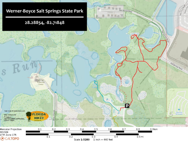
Trail Map
Explore More!
Learn more about Werner-Boyce Salt Springs State Park
 Werner-Boyce Salt Springs State Park Home to one of Florida's deepest springs, at 320 feet deep, Werner-Boyce Salt Springs State Park protects crucial coastal estuaries along the Gulf Coast.
Video
Hiking the Springs Trail
Slideshow
See our photos from the Springs Trail
Nearby Adventures
 Jay B. Starkey Wilderness Park Explore an expansive landscape of pine flatwoods, prairies, scrubby flatwoods, and open scrub along over 16 miles of hiking trails east of New Port Richey.
 Key Vista Nature Park Discover a new perspective on the Gulf of Mexico from the observation tower at Key Vista Nature Park, a coastal gem with a natural sandy beach and gentle footpaths.
 Anclote Gulf Park A place for spectacular sunsets, Anclote Gulf Park offers several observation points along its waterfront overlooking Anclote Key and the Gulf of Mexico.
 James E Grey Preserve Hugging the shores of the winding Pithlachascotee River, James E. Grey Preserve follows its natural shorelines with an extensive accessible boardwalk.

- Hal Scott Red Trail - November 13, 2026
- Baseline Trails - November 7, 2026
- Hal Scott Yellow Trail - November 3, 2026