

Short but rugged, the Beach Walk Trail at Emerson Point Preserve is an amped-up version of the Terra Ceia Trail without a handy berm to follow.
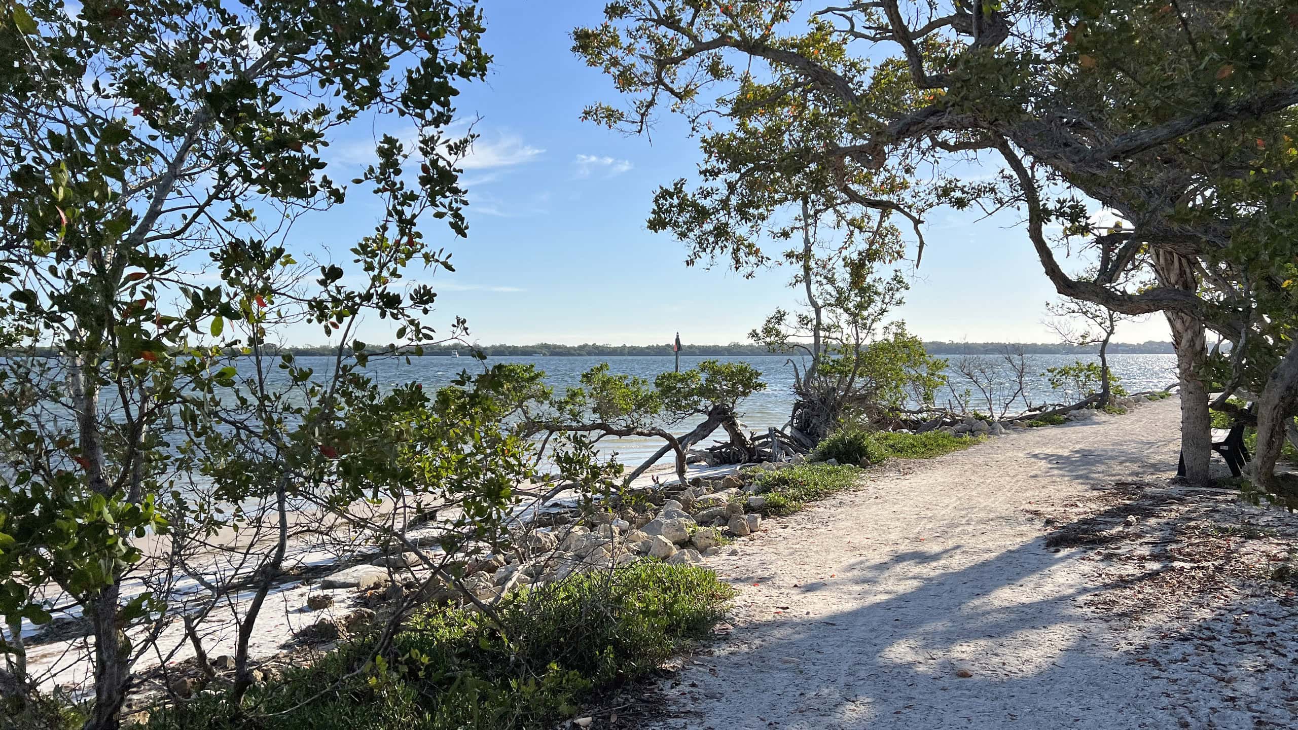
Instead, this barely discernible footpath squeezes between the bayfront mangroves and the barest of high ground on a peninsula at the point.
 A patch of high ground near trail’s end
No bicycles are permitted, and you’d be wise not to bring a dog: too easy to snag a leash, too tempting for the pup to splash somewhere into a swampy spot where you can’t follow.
Keep alert for alligators, since you are literally walking at the edge of the lapping waves beneath a wall of mangroves on Tampa Bay with a swamp on the opposite side of this spit.
 Walking right along the waterline
Resources




Disclosure: As authors and affiliates, we receive earnings when you buy through our links. This helps us provide public information on this website.
Overview
Location: Emerson Point
Length: 0.8 mile round-trip
Trailhead: 27.532323, -82.646177
Address: 5801 17th Street W, Palmetto
Fees: Free
Restroom: Portable toilet
Land manager: Manatee County
Phone: 941-748-4501
Open sunrise to sunset. Leashed dogs permitted but not advisable. Prepare for mosquitoes, which can be intense.
Directions
From Interstate 275 south of the Sunshine Skyway Bridge, exit onto US 19. Drive south into Palmetto. Turn right onto SW 10th St. After 2.5 miles, cross a small bridge onto Snead Island. At the sign for the preserve, turn right on Tarpon Rd, then left at the stop sign. The road narrows and enters the park gates. Follow it 1.5 miles to its very end.
Hike
A prominent “Beach Walk Trail” sign points out an obvious trail adjoining a kiosk at the sweep of beach defining Emerson Point.
Follow a soft white sand path under the sea grapes along the shoreline. Emerge on the slender beach for a panorama of Tampa Bay
 Start of the trail
Stick to the beaten path as it slips behind the mangroves, with a low branch to step over. Turning uphill into a scrim of tropical hammock, step through more branches and vines.
Gray nickerbean vine cascades from the sea grapes above. Deep green sea purslane, a salt-loving plant, rises in clusters from the leaf litter.
 Follow the worn path
Do your best to stay with the sand path as it approaches a pretty cove under a low canopy of mangroves.
Depending on the tide you may need to diverge from it to higher ground. Walk the ribbon of white alongside twisted rootballs of toppled mangroves.
 Mangrove roots lining small beach
Narrowing, the path forces more step-overs of low branches behind the fingerling roots of black mangroves.
Speckled with the salt they exude and the thickness of pretzel sticks, they jut from an organic mat.
 Black mangrove roots
A small cove frames the Sunshine State Skyway bridge on the Tampa Bay horizon. Broadening, the sand path looks out on the bay through the prop roots of red mangroves.
Pay close attention to movement in the trees, as mangrove crabs clamber the limbs and herons perch in their shade.
 The Sunshine Skyway on the far horizon
Reach an opening on the bay where white mangroves, the tallest of the species, send runner roots across the sand as anchors.
The path sweeps uphill slightly into coastal hammock. Descend behind the mangroves again, more outstanding views of the bay unfolding between their limbs.
 Tangled branches and coastal hammock
Follow the contour of this peninsula with the added challenge of limboing through low limbs and tangled roots hovering over the path.
Tunneling through dense vegetation, reach a small cove with a view at a quarter mile. The footpath turns inward, facing a mangrove swamp on the opposite side of the peninsula.
 Interior swamp
Ascend into a low forest of young sea grapes in a sun-drenched spot before burrowing into a tunnel of tropical vegetation. Taller trees anchor the high ground.
Face a wall of tall white mangroves, the bay visible between them. Join a tangled corridor before another spot of high ground. Cabbage palms rise above the thicket of vegetation.
 Cabbage palms mark the high ground
At not quite 0.4 mile, the trail ends in the sand clearing below them. Retrace the path back to the trailhead, with just as many climb-overs and duck unders.
The return trip nonetheless provides a very different perspective on the views of the bay. Reaching the trailhead parking area, complete a 0.8 mile hike.
 Beautiful bayfront cove
Push that up to 1.1 miles with a beach walk around the tip of Emerson Point to circle and climb Replica Mound, the high point between the picnic and parking areas.
 Bench near the base of Replica Mound
Trail Map

Dark Blue: Tower Trail. Green: Terra Ceia Trail. Yellow: Beach Trail.
Explore More!
Learn more about Emerson Point Preserve
 Emerson Point Preserve Where the Manatee River meets Tampa Bay, Emerson Point Preserve has a network of trails around a complex centered on one of Florida's most ancient temple mounds, the Portavant Mound, near Bradenton.
 Emerson Point North and South Trails A winding ribbon of crushed limestone snakes through tropical hammocks and along wetlands and mangrove forests to explore the interior of Emerson Point Preserve.
 Emerson Point Portavant Mound Trail Delve deeply into Florida's past by exploring an ancient complex of mounds fronting the Manatee River at Emerson Point Preserve.
 Emerson Point Terra Ceia Trail An immersion in mangrove forest and numerous overlooks on Terra Ceia Bay elevates the rugged Terra Ceia Trail to the best of the hikes at Emerson Point Preserve.
 Emerson Point Tower Trail Discover a unique perspective of Terra Ceia and Tampa Bay from an observation tower crowning a mound purposely built in the mangrove swamps by an ancient civilization.
Video
Hiking the Emerson Point Beach Walk Trail
Slideshow
See our photos from the Beach Walk Trail
Nearby Adventures
 De Soto National Memorial Interpreting the landing of Spanish conquistador Hernando De Soto, De Soto National Memorial occupies a peninsula where the Manatee River flows into Tampa Bay.
 Robinson Preserve Edging Tampa Bay, the vast sweep of Robinson Preserve is a puzzle of natural and restored habitats circled by more than ten miles of mixed-use trails.
 Madira Bickel Mound State Archaeological Site One among many intentional high points constructed by ancient peoples along the edges of Tampa Bay, this protected shell mound and adjacent burial site are what remain of a much larger complex at Terra Ceia.
 Terra Ceia Preserve State Park Home to many wading birds, Terra Ceia Preserve State Park is an aquatic preserve protecting the ragged northern shoreline of the island of Terra Ceia.

- Hal Scott Yellow Trail - November 3, 2026
- Hal Scott Preserve - October 28, 2026
- Tradewinds Park - October 27, 2026