

By far the most scenic hike at Emerson Point Preserve, the 1.2 mile Terra Ceia Trail follows a narrow berm through the mangrove forest fringing Terra Ceia Bay.
It is also off-limits to cyclists, and has numerous scenic overlooks. As the trail is linear, it takes some forethought to hike.
 Observation deck closest to the trailhead
The trailhead for this linear pathway adjoins a parking area and canoe launch west of the Tower Trail trailhead. At a minimum, an out-and-back to the first observation deck is a must.
However, using the Tower Trail as a pivot point and the North Trail as a connector makes for one of the best scenic loops in Florida. We outline this pretzel-shaped hike below.
 Tower Trail approach to the Terra Ceia Trail
Resources





Disclosure: As authors and affiliates, we receive earnings when you buy through our links. This helps us provide public information on this website.
Overview
Location: Emerson Point
Length: 2.6 mile loop
Trailhead: 27.534680, -82.632014
Address: 5801 17th Street W, Palmetto
Fees: Free
Restroom: At the Nature Center
Land manager: Manatee County
Phone: 941-748-4501
Open sunrise to sunset. Hiking only. Leashed dogs welcome. Prepare for intense mosquitoes and very uneven terrain.
Directions
From Interstate 275 south of the Sunshine Skyway Bridge, exit onto US 19. Drive south into Palmetto. Turn right onto SW 10th St. After 2.5 miles, cross a small bridge onto Snead Island. At the sign for the preserve, turn right on Tarpon Rd, then left at the stop sign. Follow the road as it narrows and enters the park gates. Continue straight ahead to the first parking area on the right.
Hike
Begin at the Tower Trail trailhead and follow its boardwalk through the mangroves to the mound.
Climb up to the peak clockwise on the Tower Loop Trail and ascend to the observation tower for its incredible panorama.
Descend to the loop and continue downhill on the Terra Ceia Trail boardwalk connector through the mangroves. It provides the only central access point to the trail.
Crossing a mangrove-lined waterway, reach a T intersection at a sign for the trail at 0.3 mile. Turn right.
 Start of the Terra Ceia Trail
Hemmed in by sea grapes, oaks, and mangroves, the sand path occupies much of the width of the narrow berm.
In a tenth of a mile take the boardwalk to the left to an observation deck on Terra Ceia Bay.
 Boardwalk to the bay
A staircase to the water enables paddlers to take a break and anglers to wade the shallows as they fish.
An expanse of blue dotted with small islands, the bay is a natural nursery for aquatic species thanks to its mangrove-shaded shorelines.
 Terra Ceia Bay
Return to the berm and continue north along it, watching your footing where tree roots extend across it. The paralleling ditch on the right is where this high ground came from.
Before pesticides, mosquito control efforts in Florida focused on cutting channels like these and introducing gambusia, a native fish that eats mosquito larvae.
 The narrow berm
The tangle of red mangrove prop roots that has grown up since often obscures the ditch. Red bay and oaks command the high ground after the berm diverges from the bay and widens.
White mangroves tower to surprising heights. Step over a mangrove limb splayed across the footpath.
 Mangrove limbs to step over
Making a curve, the berm remains well-shaded by an archway of trees. Grasses anchor its edges, along with a spill of grapevines.
A large prickly pear cactus rises from the slope before the next curve. Tunnel through a low canopy of mangroves, the adjoining dangling prop roots of red mangroves like draperies
 Shady rooty passageway
Mangrove-lined channels are on both sides now, a line of boards staving off erosion into the dropoff on the right. Mind the more frequent roots in the footpath.
The habitat shifts again, beds of marsh fern and cabbage palms edging the berm. Jog between the trees past another erosion barrier near a giant leather fern.
 Pausing at a thatch-like curtain of mangrove roots
Views ahead are occasionally obscured by streamers of Spanish moss. Red mangrove roots dangle at face level like thatching.
Narrowing, the berm has a tilt as it edges a mangrove swamp with tall trees beyond it. After a significant curve, slip between two arching oak limbs blocking the footpath.
 The trail’s north end is at the North Trail Loop
The Terra Ceia Trail ends at a mile. Turn right when you exit onto the North Trail Loop. It’s most direct route back to your starting point.
Bear right at each subsequent junction, reaching the Tower Trail trailhead at 1.3 miles.
 Approaching the Tower Trail trailhead
To continue this pretzel loop, take the Tower Trail boardwalk again, but this time bear right at the fork for the Tower Loop for a different approach to the Terra Ceia connector.
When the boardwalk from the mound deposits you at the T junction with the Terra Ceia Trail, turn left this time.
 Turn left at the T intersection
Cross a bridge over an outflow from the mangroves into Terra Ceia Bay. Take the next right for a zigzagging boardwalk which showcases the creek.
It ends at an observation deck among the mangroves. Returning to the berm, turn right.
 Bridge over the creek
Providing nice views of the mangrove-lined waterway adjoining it, the footpath dips in and out of a tunnel of shade.
By 1.7 miles, views open up of the bay between the mangroves. Climb a sandy, curved slope as the berm narrows while gaining more elevation.
 A glimpse of Terra Ceia Bay through the trees
Glimpse blue water through tree limbs on both sides before passing a cluster of Spanish needles, a type of yucca. One stands prominently before a curve edged by boards.
Use caution on the uneven ground as the berm narrows and pitches, with trees leaning into it. The bay remains close, a horizon of blue beyond the trees.
 Crowded passageway
Boards outline the next significant curve above the mangrove channel. Duck under low-hanging sea grapes and oak limbs on the straightaway that follows.
A broadening channel on the left resolves into an expanse of the interior lagoon that paddlers can ply. Ibis roost in the mangroves while herons stalk the edges.
 Interior lagoon
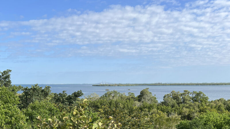
Two miles into the hike, take a right to follow a boardwalk to an observation deck on Terra Ceia Bay.
Sun-drenched benches face the distant horizon where the Sunshine Skyway Bridge crosses the bay to St. Petersburg.
 Final bayfront view
Edged by fencing at dropoffs, the wide path past the boardwalk makes for an easy finale to the Terra Ceia Trail. Round a curve before the straightaway to the park road.
At 2.1 miles, turn left to walk past the launch for the lagoon. Loop the trailhead and picnic pavilion to join the multi-use North Trail again.
 Trailhead for the Terra Ceia Trail
Paralleling the park road, walk a tenth of a mile to a crosswalk. The pathway on the south side of the road loops through the forest back to the road.
It joins one last boardwalk zigzagging through a mangrove forest. Emerging at the park road again, continue to the next crosswalk, reaching the Tower Trail trailhead after 2.6 miles.
 Paralleling the park road on the North Trail
Trail Map

Dark Blue: Tower Trail. Green: Terra Ceia Trail. Yellow: Beach Trail.
Explore More!
Learn more about Emerson Point Preserve
 Emerson Point Preserve Where the Manatee River meets Tampa Bay, Emerson Point Preserve has a network of trails around a complex centered on one of Florida's most ancient temple mounds, the Portavant Mound, near Bradenton.
 Emerson Point Tower Trail Discover a unique perspective of Terra Ceia and Tampa Bay from an observation tower crowning a mound purposely built in the mangrove swamps by an ancient civilization.
 Emerson Point North and South Trails A winding ribbon of crushed limestone snakes through tropical hammocks and along wetlands and mangrove forests to explore the interior of Emerson Point Preserve.
 Emerson Point Portavant Mound Trail Delve deeply into Florida's past by exploring an ancient complex of mounds fronting the Manatee River at Emerson Point Preserve.
 Emerson Point Beach Walk Trail Pick a path through a tangle of mangrove roots on this wild shoreline where Terra Ceia Bay and the Manatee River mingle their waters at Tampa Bay.
Video
Hiking the Terra Ceia Trail
Slideshow
See our photos from the Terra Ceia Trail
Nearby Adventures
 De Soto National Memorial Interpreting the landing of Spanish conquistador Hernando De Soto, De Soto National Memorial occupies a peninsula where the Manatee River flows into Tampa Bay.
 Robinson Preserve Edging Tampa Bay, the vast sweep of Robinson Preserve is a puzzle of natural and restored habitats circled by more than ten miles of mixed-use trails.
 Madira Bickel Mound State Archaeological Site One among many intentional high points constructed by ancient peoples along the edges of Tampa Bay, this protected shell mound and adjacent burial site are what remain of a much larger complex at Terra Ceia.
 Terra Ceia Preserve State Park Home to many wading birds, Terra Ceia Preserve State Park is an aquatic preserve protecting the ragged northern shoreline of the island of Terra Ceia.

- Michael Crotty Bicentennial Park - November 3, 2026
- A.J. Henry Park - November 1, 2026
- Okeeheelee Nature Center Trails - October 22, 2026