

No other location along the shores of Tampa Bay rivals the perspective provided from the observation tower at Emerson Point Preserve.
Built atop a mound purposely piled up to provide a clear view of the mouth of Tampa Bay at the Gulf of Mexico, it’s a must-climb.
Boardwalks bridge the mangrove swamp surrounding this mound, and a loop trail shaded by a tropical forest circles its slopes.
The Tower Trail also serves as a crucial central connector to the Terra Ceia Trail, making it possible to create loop hikes using that scenic linear trail along the bay.
 Boardwalk to the Terra Ceia Trail
Resources





Disclosure: As authors and affiliates, we receive earnings when you buy through our links. This helps us provide public information on this website.
Overview
Location: Emerson Point
Length: 0.4 mile round-trip
Trailhead: 27.533742, -82.626351
Address: 5801 17th Street W, Palmetto
Fees: Free
Restroom: At the Nature Center
Land manager: Manatee County
Phone: 941-748-4501
Open sunrise to sunset. Leashed dogs welcome. Prepare for mosquitoes in the mangrove forests and the shade.
Directions
From Interstate 275 south of the Sunshine Skyway Bridge, exit onto US 19. Drive south into Palmetto. Turn right onto SW 10th St. After 2.5 miles, cross a small bridge onto Snead Island. At the sign for the preserve, turn right on Tarpon Rd, then left at the stop sign. Follow the road as it narrows and enters the park gates. Continue straight ahead to the first parking area on the right.
Hike
The shortest of the named trails at Emerson Point Preserve, the Tower Trail begins as a boardwalk at a sign that says Observation Tower at the roadside trailhead parking area.
Framed by mangroves, the boardwalk pops out onto and spans across a mangrove-lined channel in the middle of Snead Island.
 Start of the hike
Curving through the mangroves on the far side of the waterway, you can see what appears to be a ridge in the distance topped with large trees.
A spur boardwalk leads to a bench as the gradient of mangroves shifts species from red to black to white.
 Boardwalk leading to the forested mound with the tower
Closing in on the ridge, transition into taller white mangroves. Climbing, exit the mangroves for a path curving around the contour of this plainly man-made mound.
This is the tallest of the mounds built on Snead Island, a fact that quickly makes itself known as you ascend beneath a canopy of gumbo-limbo and ficus trees.
 Curving around a massive ficus
The trail splits at the Tower Loop Trail sign at 0.2 mile. Bear left and keep climbing, the ascent getting steeper up to a bridge.
From this point you can see how the mound drops off into the surrounding mangrove swamp.
 Bridge
Turn right at the Observation Tower sign and climb the steep slope, broken by waterbars to fight erosion, up to a bench.
Curve around and keep climbing to the very peak, where the trees still obscure any views. Ascend the corkscrew of staircase to the top of the tower.
 Steep climb to the base of the tower
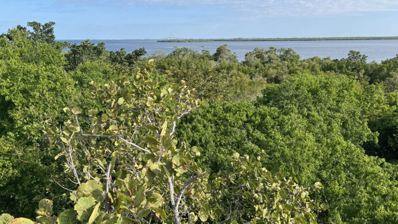
From this perch, the importance of this mound becomes clear. At this great height, the mound builders could see the mouth of Tampa Bay, now obscured a bit by forest.
They could also have signaled other mound complexes across the water. To the northeast, the Sunshine State Skyway is beyond Terra Ceia.
 The Sunshine State Skyway is an easy landmark to pick out
Atop that island, a tall mound blanketed by tropical forest is now protected as a state park; a large complex of mounds occupied the tip of the peninsula before development.
Look due east. While the height of the surrounding forest makes it impossible to see the Manatee River, a tell-tale landmark is the cross on its far shore at Riverview Pointe Preserve.
 View northeast towards the Gulf of Mexico
Review the panoramas in each direction before descending the tower and the peak of the mound.
At the base of the Observation Tower descent the trail splits three ways. To the right, the Tower Loop Trail loops around the other side of the mound.
 Descent to the trail junction
To complete the loop, make a right and walk in the deep shade of the tropical coastal forest.
Beyond a showy display of native sunflowers, descend past a native plant nursery to the original loop junction.
 Sunflower patch near the nursery
Continue downhill and cross the mangrove forest boardwalk to reach the trailhead for a 0.4 mile hike on the Tower Trail.
On its far side directly below the climb to the tower, the Tower Trail also provides access to the Terra Ceia Trail.
 Connecting boardwalk to the Terra Ceia Trail
From the Observation Tower junction, descend the connector to a boardwalk into the mangroves. It bridges an old mosquito control canal to reach the Terra Ceia Trail.
Minus the climb to the tower, this T intersection is 0.3 miles from the trailhead, no matter which side of the Tower Loop Trail you take to reach it.
 T intersection with Terra Ceia Trail
Trail Map

Dark Blue: Tower Trail. Green: Terra Ceia Trail. Yellow: Beach Trail.
Explore More!
Learn more about Emerson Point Preserve
 Emerson Point Preserve Where the Manatee River meets Tampa Bay, Emerson Point Preserve has a network of trails around a complex centered on one of Florida's most ancient temple mounds, the Portavant Mound, near Bradenton.
 Emerson Point Beach Walk Trail Pick a path through a tangle of mangrove roots on this wild shoreline where Terra Ceia Bay and the Manatee River mingle their waters at Tampa Bay.
 Emerson Point North and South Trails A winding ribbon of crushed limestone snakes through tropical hammocks and along wetlands and mangrove forests to explore the interior of Emerson Point Preserve.
 Emerson Point Portavant Mound Trail Delve deeply into Florida's past by exploring an ancient complex of mounds fronting the Manatee River at Emerson Point Preserve.
 Emerson Point Terra Ceia Trail An immersion in mangrove forest and numerous overlooks on Terra Ceia Bay elevates the rugged Terra Ceia Trail to the best of the hikes at Emerson Point Preserve.
Video
Hiking the Emerson Point Tower Trail
Slideshow
See our photos from the Tower Trail
Nearby Adventures
 De Soto National Memorial Interpreting the landing of Spanish conquistador Hernando De Soto, De Soto National Memorial occupies a peninsula where the Manatee River flows into Tampa Bay.
 Riverview Pointe Preserve Protecting eleven acres of waterfront adjacent to De Soto National Memorial, this dog-friendly coastal park features a beach on the Manatee River.
 Madira Bickel Mound State Archaeological Site One among many intentional high points constructed by ancient peoples along the edges of Tampa Bay, this protected shell mound and adjacent burial site are what remain of a much larger complex at Terra Ceia.
 Terra Ceia Preserve State Park Home to many wading birds, Terra Ceia Preserve State Park is an aquatic preserve protecting the ragged northern shoreline of the island of Terra Ceia.

- Hal Scott Yellow Trail - November 3, 2026
- Hal Scott Preserve - October 28, 2026
- Tradewinds Park - October 27, 2026