• Skip to main content
  • Skip to header right navigation
  • Skip to after header navigation
  • Skip to site footer
Florida Hikes logo

Florida Hikes

Hike Bike Paddle Camp Florida with authors Sandra Friend and John Keatley as your guides

  • Trails
  • Maps
  • Guidebooks
  • Hike
    • Scenic Hikes
    • Loop Trails
    • Dog-friendly Hikes
    • Hikes for Kids
    • National Parks in Florida
    • Florida State Parks
  • Bike
    • Major Bike Trails
    • Paved Bike Trails
    • Off Road Biking
    • Biking Articles
  • Paddle
    • Canoe & Kayak Rentals
    • Paddling Destinations
    • Paddling Articles
  • Camp
    • Cabin Rentals
    • Car Camping
    • Primitive Camping
  • Florida Trail
    • Plan your Hike
    • Best Scenic Hikes
    • Best Backpacking
    • Section Hiking
    • Thru-Hiking
    • Trail Updates
  • Travel
Gordon River Greenway boardwalk

Gordon River Greenway

Get a new perspective on Naples along the Gordon River Greenway, where you can hike, bike, or paddle through the city’s urban mangrove forest.

Naples (26.1678, -81.7880)   2.6 miles  

Bringing together landowners along the Gordon River in 1988, the Southwest Florida Land Preservation Trust worked with them to develop an urban recreation corridor.

It took 30 years for each element of the 140-acre linear park to fall into place. It now connects the Golden Gate Parkway most of the way to downtown Naples.

While you are most likely to explore it on foot or by bicycle, the Gordon River Greenway also allows paddlers to put in and parallel the paved pathway.

Gordon River Exploring the greenway from the Gordon River


The greenway incorporates an interesting mix of boardwalks, bridges, natural pathways, and paved trail through and along the mangrove forest surrounding its namesake waterway.

Thanks to the dense mangrove forest along its shores, this is an excellent destination for wildlife watching.

Gordon River Greenway Start of the trail at the South Parking Area


Resources

Resources for exploring the area
Hikers Guide to the Sunshine State book cover 50 Hikes in South Florida book cover South Florida Explorers Guide book cover Paddlers Guide Florida Hiking the Gulf Coast book cover
 
Disclosure: As authors and affiliates, we receive earnings when you buy through our links. This helps us provide public information on this website.

Overview

Location: Naples
Length: 2.6 miles round-trip
Trailhead: 26.1678, -81.7880
Address: 1580 Goodlette-Frank Rd
Fees: Free
Restroom: at both parking areas
Land manager: Collier County
Phone: 239-252-4000

Open 6:30 AM to 10 PM daily. The Gordon River Greenway is lighted along its length and the lamp posts have ID numbers to reference in case of an emergency.

Leashed dogs welcome. Frequent benches make this an easy stroll for all ages. There is a playground at the North Parking Area.

Bicycles welcome. Yield to pedestrians. Be cautious on the boardwalks when they are wet.

Contact the Conservancy of Southwest Florida at 239-213-2500 to arrange a guided kayak tour or an electric boat ecotour along the river.

Members of the conservancy may rent kayaks and launch into the Gordon River from their private landing. Their nature center is just a little south of the South Parking Area.

Gordon River Kayaks at the Conservancy dock


Directions


The South Parking Area, which we used, adjoins the Zoo at Caribbean Gardens. From US 41, take Golden Gate Pkwy west (or from Airport-Pulling Rd, take it east) and turn south on Goodlette-Frank Rd. Enter the parking area for the zoo and drive all the way to the back of it to find the park. The North Parking Area is along Golden Gate Pkwy almost a block west of Goodlette-Frank Rd on the south side of the highway, at 1596 Golden Gate Pkwy. A walk-in entrance is on Post Rd, behind the Naples Airport.

Following the Greenway

On our visit to Naples, we spent one evening walking part of the Gordon River Greenway. We came back the next morning to bike it.

Our time was limited, so we concentrated our efforts on going south to find the end of the greenway behind the Naples Airport.

Gordon River Greenway Following the winding boardwalk through the mangrove forest


Our 2.6 mile round trip by bike is shown in red on the Trail Map at the bottom of this page.

The portions in blue include the 0.7-mile North Loop that connects to the North Trailhead, and the 0.4-mile nature trail in the pine flatwoods.

Mangrove rubber vine in bloom

Bike

Starting out from the circle at the South Parking Area, follow the paved path up to the boardwalk.

The paddler put-in is just south of the paved path. The river is very narrow here, flowing southward towards downtown

Gordon River Greenway The Gordon River


The boardwalk is broad, so it isn’t a problem to pass by other cyclists and hikers as it curves through the mangrove forest.

It meets the first trail junction after 0.2 mile, a junction of boardwalks where the North Loop begins. Directional signage helps you keep your bearings.

Gordon River Greenway Boardwalk with directional signs


Continue straight ahead and pass a rain shelter. When the boardwalk ends at a T, turn right. The left turn is the other end of the 0.7-mile North Loop.

The trail becomes a broad paved path through pine flatwoods. A paved circle with benches marks the entrance to a footpath that arcs through the woods.

Gordon River Greenway Biking through slash pine flatwoods


That 0.4-mile nature trail has a second access point at a covered bench farther along the trail.

Pass another covered bench that sits on the edge of a wetland. This is a nice place to stop and watch for birds.

Gordon River Greenway Covered bench at the south end of the nature trail


As pine flatwoods yield to the mangrove forest again at 0.6 mile, the trail once again becomes a boardwalk weaving through it.

Another rain shelter also serves as an overlook on the river. Past it, it’s a surprise to cross a broad waterway.

Gordon River Greenway Looking at an observation deck up ahead


While we thought it was the Gordon River, it only is where you look south.

The waterway is actually one of the main drainage canals in Naples. It empties into the Gordon River at this point and widens it significantly.

Gordon River Greenway View south along the Gordon River


Making a sharp turn as the boardwalk reaches the far shore, it passes another covered shelter when the boardwalk ends.

This one has an observation deck behind it for better views up and down the river than the bridge.

Gordon River Greenway Peeking out along the Gordon River from the paved path


Beyond this stop, the paved path sticks close to the river, with lots of views of it through the trees.

As it turns away from the river, it winds through a sparse tropical hammock. Brightly colored fungi rose from the damp forest floor.

Gordon River Greenway Taking a break near the south end of the trail


The trail crosses the mangrove swamp one last time as it curves towards the airport, where the path presses up against the airport fence.

This straightaway comes to an end at Port Avenue. This is the end of the greenway and our turn-around point after 1.3 miles.

Gordon River Greenway Airport The southernmost piece of the greenway


Looking at the map, it appears you could ride south on 19th St and use Baker Park to cross the river and connect with the side path along Goodlette-Frank Rd into downtown.

On the return trip, we made more stops and paid more attention to the details of the forest while retracing our route.

Gordon River Greenway Nature Trail Trailhead for the nature trail


Once past the nature trail loop in the pine flatwoods, we turned left rather than follow the North Loop.

That took us past the rain shelter along the boardwalk between the two ends of the North Loop for a final time.

Gordon River Greenway Rain shelter along the boardwalk


The boardwalk zigzagged through the mangroves back to the South Parking Area.

We enjoyed one last look at the Gordon River before we returned to the trailhead for a 2.6-mile ride.

Gordon River Greenway boardwalk
Along a boardwalk on the Gordon River Greenway

Hike

Follow the same route as outlined above for a hike to the south end of the Gordon River Greenway.

On foot instead of by bike, there is time to pause and watch for birds and fish from the river bridge.

Gordon River Greenway School of mullet in the Gordon River


You also notice a lot more detail in the mangrove forest. Mangrove crabs scurry along the trunks and on the boardwalk.

Bromeliads of every shape and size thrive among the mangroves. Vines of mangrove rubber vine tangle through them too.

Gordon River Greenway Look deeply into the mangrove forest


We walked out to the trail junction, passing the rain shelter both ways, and turned around when the rain started.

If you make a left at the trail junction and do the North Loop, that adds another 0.7 mile to the route.

If you make a right and also walk the wood-chip path through the pines in addition to the bike route we describe, it’s 3.7 miles to cover all the trails by foot.

Gordon River Greenway John pausing for a view down the Gordon River


Trail Map
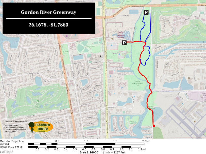
Gordon River Greenway Trail Map
Red: route described. Blue: additional loops.

Explore More!

Slideshow

See our photos of the Gordon River Greenway


Nearby Adventures

Boardwalk among cypress trees Fred W Coyle Freedom Park In northeast Naples, an impressive network of accessible paved pathways and boardwalks meander across a mosaic of ponds and natural wetlands teeming with wildlife.
Peering out from tropical plants at a path Naples Zoo at Caribbean Gardens Established in 1919 by botanist Henry Nehrling, what is now the Naples Zoo at Caribbean Gardens has improved over a century's worth of expansion into an accredited zoological park.
Lily pond perched above walkway with people Naples Botanical Garden At Naples Botanical Garden, buildings, landscaping, and nature live in harmony, with a delicate balance of natural spaces and lush gardens accented with art achieved.
Mangroves up close Rookery Bay NERR Protecting vast mangrove forests and coastal habitats between Naples and Ten Thousand Islands NWR, Rookery Bay NERR encompasses a mind-boggling 110,000 acres.

Trail Map Advocacy Website Official Website

  • Author
  • Recent Posts
Sandra Friend & John Keatley
Articles jointly researched, written, and photographed by Sandra Friend & John Keatley, authors and publishers of FloridaHikes.com.
Sandra Friend & John Keatley
Latest posts by Sandra Friend & John Keatley (see all)
  • Hal Scott Red Trail - November 13, 2026
  • Baseline Trails - November 7, 2026
  • Hal Scott Yellow Trail - November 3, 2026
Category: Access by water, Biking, Canoe & Kayak Rentals, County Parks, Greenways, Hikes, Launch Points, Nature Trails, Paddling, Paved Bike Trails, Southwest Florida, TrailsTag: Accessible, Birding, Dog-friendly, Family-Friendly, Gordon River, Mangroves, Naples, Playgrounds, Wildlife Viewing

Sidebar

FarOut Guides

Our comprehensive trail logistics presented on offline maps:

Florida National Scenic Trail (1,500 miles)
Florida Keys Overseas Heritage Trail (108 miles)
Eastern Continental Trail in Florida (92 miles)


We earn a small commission on sales through these links. Thanks for your support!


Our Guidebooks

We’ve written Florida guidebooks for over 25 years. These include Southwest Florida destinations.

Book cover with woman hiking through palms with baby carrier
Book cover of Florida Trail Hikes
The Florida Trail Guide fifth edition

Explore More

Newest Articles for Southwest Florida

Showy cloudscape beyond a sand road in scrub Oscar Scherer Green Trail
View of open water framed by trees Calusa Heritage Trail
Footpath dipping into dampness amid mangroves Nancy Weir Mangrove Preserve
Firebreak and grassy strip through pine flatwoods Scherer Thaxton Preserve

  • Facebook
  • Flickr
  • Instagram
  • Pinterest
  • Substack
  • Vimeo

FIND A TRAIL OR PARK

METROS: Bradenton. Clearwater. Crestview. Daytona Beach. Destin. Fort Lauderdale. Fort Myers. Fort Walton Beach. Gainesville. Jacksonville. Kissimmee. Lakeland. Melbourne. Miami. Naples. Ocala. Orlando. Panama City Beach. Pensacola. Port St. Lucie. Punta Gorda. St. Petersburg. Sanford. Sarasota. Sebring. Stuart. Tallahassee. Tampa. Vero Beach. West Palm Beach.

MULTI-REGION: Atlantic Coastal Ridge. Atlantic Coast. Bartram Trail. Big Bend. East Coast Greenway. Everglades National Park. Florida National Scenic Trail. Gulf Coast. Lake Wales Ridge. WATERWAYS: Indian River Lagoon. Intracoastal Waterway. Kissimmee River. St. Johns River. Withlacoochee River.

NORTHWEST FLORIDA: Altha. Apalachicola. Apalachicola National Forest. Big Bend Scenic Byway. Blackwater River State Forest. Blountstown. Bonifay. Bristol. Bruce. Cantonment. Cape San Blas. Carrabelle. Chattahoochee. Chipley. Crawfordville. DeFuniak Springs. Eastpoint. Ebro. Eglin Air Force Base. Freeport. Fountain. Gulf Breeze. Gulf Islands National Seashore. Holt. Madison. Marianna. Milton. Monticello. Mossy Head. Munson. Navarre. Navarre Beach. Newport. Niceville. Panacea. Panama City . Perdido Key. Ponce De Leon. Port St. Joe. Quincy. Santa Rosa Beach. Sopchoppy. South Walton. St. George Island. St. Marks. St. Marks NWR. Sumatra. Vernon. Wakulla. Wewahitchka. Woodville. WATERWAYS: Apalachicola River. Blackwater Bay. Blackwater River. Chipola River. Choctawhatchee Bay. Choctawhatchee River. Coastal Dune Lakes. Ochlockonee Bay. Perdido River. St. Marks River. Wacissa River. Wakulla River. Yellow River.

NORTH FLORIDA: Alachua. Amelia Island. Archer. Baldwin. Branford. Bronson. Bunnell. Callahan. Cedar Key. Chiefland. Crescent City. Cross City. Cross Creek. Dowling Park. Ellaville. Fanning Springs. Fernandina Beach. Flagler Beach. Fort White. Glen St. Mary. Green Cove Springs. Hawthorne. High Springs. Inglis. Jacksonville Beaches. Jacksonville Northshore. Jasper. Jennings. Keystone Heights. Lake Butler. Lake City. Live Oak.Macclenny. Mandarin. Mayo. Mayport. Micanopy. Middleburg. Old Town. Olustee. Orange Park. Osceola National Forest. Palatka. Palatka-Lake Butler Trail. Palm Coast. Palm Valley. Perry. Ponte Vedra. Rodman. Salt Springs. St. Augustine. Starke. Steinhatchee. Suwannee. Suwannee River Wilderness Trail. Suwannee Springs. Talbot Islands. Timucuan Preserve. Trenton. Waldo. Welaka. White Springs. Williston. Worthington Springs. Yankeetown. WATERWAYS: Santa Fe River. St. Marys River. Suwannee River. Tolomato River. Upper Withlacoochee River.

CENTRAL FLORIDA: Altamonte Springs. Apollo Beach. Apopka. Astatula. Astor. Auburndale. Bartow. Babson Park. Bayport. Belleview. Bithlo. Brandon. Brooksville. Bushnell. Canaveral National Seashore. Cassadaga. Christmas. Chuluota. Citrus Springs. Clearwater Beach. Clermont. Coast to Coast Trail. Cocoa. Cocoa Beach. Cross Florida Greenway. Crystal River. Dade City. De Leon Springs. DeBary. Deland. Deltona. Dunedin. Dunnellon. Edgewater. Enterprise. Eustis. Ferndale. Fort Meade. Frostproof. Geneva. Gibsonton. Haines City. Hernando. Hernando Beach. Holopaw. Homosassa. Inverness. Kenansville. Kissimmee. Lake Mary. Lake Wales. Largo. Leesburg. Lithia. Longwood. Lutz. Maitland. Malabar. McIntosh. Melbourne Beach. Merritt Island. Merritt Island NWR. Mims. Mount Dora. Narcoossee/Lake Nona. New Port Richey. New Smyrna Beach. Nobleton. Oak Hill. Oakland. Ocala National Forest. Ocklawaha. Ocoee. Oldsmar. Orange City. Ormond Beach. Osteen. Oviedo. Paisley. Palm Bay. Plant City. Poinciana. Polk City. Ponce Inlet. Port Orange. Ridge Manor. Riverview. Ruskin. Safety Harbor. Silver Springs. Sorrento. Spring Hill. St. Cloud. Tarpon Springs. Thonotosassa. Titusville . Umatilla. Viera. Walt Disney World. Weeki Wachee. Weirsdale. Wimauma. Windermere. Winter Garden. Winter Haven. Winter Park. Winter Springs. Withlacoochee State Forest. Withlacoochee State Trail. Yeehaw Junction. Zephyrhills. WATERWAYS: Alafia River. Halifax River. Hillsborough River. Lake Apopka. Little Manatee River. Ochlawaha River. Rainbow River. Tampa Bay. Wekiva River. Wekiva River Basin.

SOUTHWEST FLORIDA: Alva. Boca Grande. Cape Coral. Charlotte Harbor. Ding Darling NWR. Ellenton. Englewood. Estero. Immokalee. Marco Island. North Port. Osprey. Palma Sola. Palmetto. Pine Island. Port Charlotte. Sanibel Island. Venice. WATERWAYS: Caloosahatchee River. Manatee River. Myakka River. Pine Island Sound.

SOUTH FLORIDA: Arcadia. Basinger. Big Cypress National Preserve. Big Cypress Seminole Reservation. Big Cypress Swamp. Bowling Green. Clewiston. Everglades City. Indiantown. LaBelle. Lake Okeechobee Scenic Trail. Lake Placid. Lakeport. Moore Haven. Okeechobee. Ortona. Pahokee. Palmdale. Port Mayaca. South Bay. Wauchula. Zolfo Springs. WATERWAYS: Fisheating Creek. Lake Okeechobee. Peace River.

SOUTHEAST FLORIDA: Biscayne Bay. Biscayne National Park. Boca Raton. Boynton Beach. Coconut Creek. Coral Gables. Coral Springs. Davie. Delray Beach. Fellsmere. Flamingo. Fort Pierce. Hobe Sound. Hollywood. Homestead. Indrio. Jensen Beach. Juno Beach. Jupiter. Jupiter Farms. Key Biscayne. North Hutchison Island. Ocean to Lake Greenway. Palm Beach. Palm Beach Gardens. Pompano Beach. Redland. Sebastian. South Hutchinson Island. WATERWAYS: Florida Bay. St. Lucie River.

FLORIDA KEYS: Big Pine Key. Islamorada. Key Largo. Key West. Marathon. Overseas Heritage Trail.


©2006-2026, Sandra Friend & John Keatley | Disclosure | Site Index | Work with Us | Advertise with Us | Terms of Service and Privacy Policy

Florida Hikes PO Box 93 Mims FL 32754 | Contact