
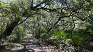
One of Florida’s top hiking destinations, the Guana River Trails at GTM Research Reserve have their roots in Guana River State Park, which still existed on our initial visit in 2002.
By 2004, it was absorbed into Guana-Tolomato-Matanzas National Estuary Research Reserve (GTM NERR), one of three such research reserves in Florida and thirty nationally.
 Estuary frontage on the Tolomato River
Protecting 76,000 acres of estuary surrounding St. Augustine, the Reserve, as a staffer told us, is “all about research.” Staff isn’t involved with the trail system.
Instead, maintaining the pre-existing trail system fell to volunteers. Not only do they keep it up, they’ve enhanced it greatly with the help of Eagle Scouts.
 Boardwalk along the Blue Trail
Thanks to the Friends of the GTM Reserve, this is one of the most well-marked, well-kept, and intutive trail networks in the state.
Junctions are well-marked with color coded arrows and posted maps. Benches are color coded to the trails.
 Bench along the Red Trail spur to the river
Traversing a broad variety of habitats, it skirts significant archaeological sites. The loops interconnect frequently, so you can easily tailor the length of your hike on the go.
Our narrative below includes the outer perimeter with a few change-ups to make it more scenic, plus call-outs of spots to shorten your hike.
 Most of the trails are canopied
Resources





Disclosure: As authors and affiliates, we receive earnings when you buy through our links. This helps us provide public information on this website.
Overview
Location: Ponte Vedra Beach
Length: Up to a 9.6 mile hike
Trailhead: 30.022325, -81.332188
Address: 505 Guana River Rd, Ponte Vedra Beach
Fees: $3 per vehicle or $1 per cyclist / pedestrian
Restroom: At the trailhead
Land Manager: GTM NERR
Phone: 904-380-8600
Open 8 AM to sunset. Leashed dogs welcome. The parking lot gate is locked at sunset. Bring mosquito repellent!
Trails are shared with cyclists and equestrians and interconnect with adjoining Guana River WMA.
If this region is new to you, stop at the Visitor Center for an overview of the habitats in this preserve and their inhabitants before tackling the trails.
 Visitor Center
Directions
From Interstate 95, exit at SR 16 at St. Augustine and follow it east 5.2 miles to A1A. Turn north and take A1A across the causeway and bridge to Vilano Beach. Turn sharply north to parallel the Atlantic Ocean; 7.4 miles after that turn, the reserve entrance is on the left. Pay the entrance fee and proceed straight ahead unless you’re making a stop at the Visitor Center, which is uphill to the left. The entrance road crosses the Guana River dam to trailhead parking at the end of the road. If it’s full, backtrack to the large parking lot at the Visitor Center, with a half mile walk to reach the trailhead.
Hike
A sidewalk leads from the parking area into the forest canopy to a picnic pavilion and restrooms.
A kiosk at this trailhead complex has an overview map. Current trail conditions for each of the trails are grease-penciled into a color-coded grid.
 Trailhead
Behind the pavilion is a 0.3 mile accessible loop, the Sensory Trail. An optional add-on to your traverse of the trail system, it’s a pathway of pavers through the maritime hammock.
Along this beautiful introduction to the reserve, Interpretive stops encourage you to use your senses to experience the habitat. We stopped and walked it on our way out.
 Approaching an interpretive stop on the Sensory Trail
All trails branch from the Yellow Trail, a linear path connecting the trailhead with the Tolomato River.
Pause at the trail shelter with the yellow bench for information on the human history of this peninsula and the archaeological sites along this hike.
 Interpretive shelter
Marker 1 at the first trail junction is typical of those found throughout the preserve, topped with a locator map and inscribed with color coded arrows indicating trail directions.
The outer loops of the Purple Trail southbound and the Orange Trail northbound start here.
 Marker 1 junction
The Orange Trail begins as a broad forest road providing access to adjoining Guana River WMA. Skip past it, staying on the Yellow Trail beneath the live oak canopy.
Emerge at a panorama of freshwater savanna, a boardwalk guiding you to a shelter with a bench overlooking the expanse.
 Little bench on the savanna
Showy clusters of white-tipped star rush edge the sweep of trail along the savanna. At a half mile, leave this forest road to join the Orange Trail at Marker 8.
Deeply shaded by enormous live oaks, it wriggles through an understory of saw palmetto to a boardwalk with an orange bench overlooking a cove off the savanna.
 Start of the Orange Trail behind Marker 12
A quarter mile along this trail, meet Marker 12. Turn right, leaving the Orange Trail for the Blue Trail.
A mixed forest of oaks and pines opens onto the savanna at a lengthly boardwalk providing outstanding views.
 First junction of Orange and Blue Trails at Marker 12
A shelter with a blue bench provides interpretation of this linear freshwater marsh inside a swale between ancient dunes.
Showy sprays of sand cordgrass wave in the breeze. The boardwalk ends at a footpath through the pine flatwoods.
 Interpretive shelter on the boardwalk
Meet the next trail junction at Marker 3. At 1.1 miles, this is where the Orange Trail intersects from the road into Guana River WMA.
Two spur walks from this junction are worth taking before you continue along the loop to the left. Straight ahead, a spur trail leads to a gate into the WMA at Big Savannah Pond.
 Interpretive area just past the gate
An interpretive shelter illustrates the string of freshwater savannas that extend through linear Guana River WMA. Its main trailhead in Palm Valley is ten miles north.
A boardwalk ascends to an observation deck for birding on the savanna. In some seasons, it’s completely dry, in others, a shallow, transparent sheen.
 Wet season at Big Savannah Pond
Return to Marker 3 and take the boardwalk to the left. It’s the first of a pair crossing the savanna, with a waterway flowing beneath it from Big Savannah Pond.
Enter a beautiful stretch of hardwood hammock, the second boardwalk bridging to another showy hammock.
 One of the oak hammocks on this piece of the Orange Trail
Pop out at an orange bench on the forest road into Guana River WMA. This is the first spot along the trail network where you can loop back to the trailhead via the Orange Trail.
It’s a 2.1 mile hike if you turn right at the bench. Otherwise turn around to repeat this gorgeous stretch of footpath and boardwalks twice.
 Returning across the far boardwalk
At 1.7 miles, reach Marker 3 for the third time. Continue straight ahead on the Orange Trail.
Emerge from an oak hammock into an extensive pine flatwoods before returning to the tunnel of shade. At the Bench sign in the next stretch of pine flatwoods, turn right.
 Oak hammock in the pine flatwoods
This short spur at 2.1 miles leads to an overlook on a tidal pond edged by cedars. Return to the Orange Trail to walk through pine flatwoods to the next oak hammock at Marker 4.
It marks a junction with a final connector trail into Guana River WMA, not far from the shoreline of the Tolomato River.
 Bench at the tidal pond
Pass this junction, savoring the shade on the Orange Trail under swaying draperies of Spanish moss. As it approaches the river floodplain, the earth underfoot becomes darker.
It may be mucky in spots. Cedars become more prevalent on the approach to a walk along a salt marsh.
 Causeway through the salt marsh
A path marked “Bench” ends at an outstanding view of the estuary and the Tolomato River beyond. Backtrack to the main trail for a pleasant walk through the maritime hammock.
A great deal of this peninsula is wrapped in this shady coastal forest dominated by moss-draped live oaks, towering hickories, and Southern magnolias
 The Tolomato River estuary as seen from the bench
Meet Marker 5 at 2.8 miles. This is your second opportunity to shorten the loop, as Marker 12 is only a tenth of a mile to the left.
Retracing your route to it via the Orange and Yellow Trails to the trailhead would result in a 3.4 mile hike.
 Marker 5 junction
For our longer trek, pass Marker 5, joining the Blue Trail through the lush maritime hammock.
Within a tenth of a mile, the forest frames an outstanding panorama. A blue bench overlooks another mighty sweep of salt marsh.
 Salt marsh panorama
Enjoy the dappled shade of the forest as the path passes under archways of oaks, passing silver-hued clumps of saw palmetto.
A sometimes mucky stretch has oaks towering above it, their highest limbs stripped to sparse leafiness by past hurricanes.
 Hurricane-stripped oaks
The soggy forest floor is thanks to the tidally influenced marsh visible through the understory. Past a pine trunk of sizable girth, walk beneath incredibly tall slash pines.
At 3.3 miles, meet the Yellow Trail at a bench and trail marker. Turn right for a short trip to the Tolomato River.
 Upcoming junction with the Yellow Trail
A cedar grove tops the sandy ridge at trail’s end. Descend a beach with picnic tables close to the water’s edge.
Step onto the shoreline for unobstructed views up and down the river. To the south, a fenced-off area protects a coastal archaeological site.
 Tolomato River beach
Return along the Yellow Trail, passing the Blue Trail junction to tunnel through deep shade in the maritime forest.
With lengthy views of what’s coming up ahead, it’s one of the prettiest stretches of trail on this hike.
 Showy tunnel of forest on the Yellow Trail
At 3.7 miles, Marker 7 denotes the north end of the Purple Trail. Exiting to the trailhead from this junction via the Yellow Trail wraps up a 4.4 mile hike.
To continue exploring the perimeter of the trail system, turn right. Densely wooded, the Purple Trail parallels the Tolomato River south.
 Purple Trail junction at Marker 7
It gently curves under the oaks after passing a purple bench. Surrounded by a grassy forest floor, the two-track becomes damper as it edges close to the river’s marshes.
A little elevation carries the trail into the shady maritime hammock for a stretch. Bolstered by fill, it crosses a marshy spot.
 Purple bench in the shade
Cabbage palms and oaks dominate on the approach to Marker 9 at 4.8 miles. Unless you want to cut off the trip to the tip of the peninsula, continue straight ahead to join the Red Trail.
Staying close to the Tolomato River but not at the water’s edge, the Red Trail provides occasional glimpses of the waterway. Pass a red bench before the trail makes a turn.
 Shell fragments from ancient middens pepper the trail
The spur trail at Marker 11, 5.7 miles into the hike, leads 0.7 mile to the end of the peninsula.
From a low bluff, survey the sweep of estuary where the Guana River intermingles with the Tolomato.
 The estuary at trail’s end
Spills of oyster shells from ancient middens splay across the sand down to the river’s beach.
The beach widens to the right to accommodate a picnic table and another fenced-off archaeological site.
 The Tolomato River at trail’s end
Resume the loop along the Red Trail as it makes its northward turn into the maritime hammock, passing a red park bench under a Southern magnolia.
Reach Marker 10 at 8 miles. It denotes where the Red Trail ends at the return loop of the Purple Trail. Bear right to follow the broad forest road through dappled shade.
 Bench along the Purple Trail
This side of the loop curves to match the Guana River marshes hidden behind the scrim of forest. Past the second bench, the canopy opens up, more sunlight saturating the trail.
Close your loop at Marker 1 after 9.4 miles. Turn right to exit. After a quick loop around the Sensory Trail, emerge at the parking area, finishing a 9.9 mile hike.
 A gopher tortoise lives in front of the Sensory Trail
Trail Map

Explore More!
Video
A walk through the GTM Guana River Trails
Slideshow
See our photos from this trail system
Nearby Adventures
 Fort Mose Historic State Park Interpreting the first free African settlement in what would become the United States, Fort Mose educates through storytelling along 1.1 miles of trails and within its museum.
 Stokes Landing Conservation Area Fronting a vast estuary along the Tolomato River basin, Stokes Landing Conservation Area contrasts deeply shaded maritime hammock and marsh rims with panoramic views.
 Castillo de San Marcos The only remaining 17th century fortress in North America, the Castillo de San Marcos defended the Spanish colony of St. Augustine from two British sieges in the 1700s.
 Anastasia State Park Anastasia State Park is windswept and sandy, with an arc of beach that stretches four miles to Matanzas Inlet, curving in on itself to face the ancient city of St. Augustine.

- Hal Scott Red Trail - November 13, 2026
- Baseline Trails - November 7, 2026
- Hal Scott Yellow Trail - November 3, 2026