
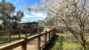
An extraordinary example of a city greenway, Lafayette Heritage Trail Park in Tallahassee provides a surprisingly quiet corridor edging the Lake Lafayette basin.
Topography and dense forests are to thank. From the wooded edge of suburbia, the greenway quickly descends out of sight and sound of surrounding neighborhoods.
 One of the more popular features along the trail is its Canopy Walkway
A draw for hikers, trail runners, dog walkers, off-road cyclists, and paddlers, this ribbon of public land has both water and land trails, gentle and rugged trails.
While there are four trailheads to choose from, the Heritage Trail Park trailhead is central to the complex of trails, providing a short accessible path, picnic area and playground.
 Residents can walk into the greenway from neighborhoods largely invisible to trail users
It provides easy access from its central trailhead for anglers to Piney Z Lake, a stocked 193 acre expanse of open water managed by FWC.
The lake is an man-made artifact, created by a former landowner by building dams across what was once a vast natural polje similar to Paynes Prairie in Gainesville.
 Fishing Piney Z Lake
Resources





Disclosure: As authors and affiliates, we receive earnings when you buy through our links. This helps us provide public information on this website.
Overview
Location: Tallahassee
Length: 17.6 miles in seven trails
Trailhead: 30.440307, -84.192092
Address: 4900 Heritage Park Blvd, Tallahassee
Fees: Free
Restroom: At most trailheads
Land manager: City of Tallahassee
Phone: 850-891-3866
Open sunrise to sunset. Leashed dogs welcome.

Directions
From the intersection of US 27 (Apalachee Parkway) and Capital Circle Southeast in Tallahassee, head east 1.4 mile to Conner Blvd. Turn left. Continue 0.7 mile and make a right onto Heritage Park Blvd. Continue a quarter mile. At the traffic circle continue straight ahead to stay on Heritage Park Blvd. The road ends at the park in another quarter mile.
Hike
Lafayette Heritage Trail East
The eastern and western portions of the Lafayette Heritage Trail, the shared-used main trail across the entire park, are very distinct in character.
East of the Heritage Park trailhead, the path is generally as broad as a forest road and nicely shaded by deciduous forest.
 Lafayette Heritage Trail East
Marked with green diamonds, it curves and narrows in a few spots, but is largely wide enough for large groups to walk together and cyclists to pass easily.
Numbered “Fishing Fingers,” protrusions of grassy levees into Piney Z Lake, provide places for bank fishing as well as panoramas of the lake.
 Angler on a Fishing Finger
The trail starts across East Levee a mile east of the trailhead. It is one of two levees built in the 1950s by the landowner to pool water in the wet prairie system of Lake Lafayette.
As a result, there is open water in Piney Z, and a haunting expanse of cypress swamp in Lower Lake Lafayette.
 Crossing East Levee
Once across the levee and into the woods, the trail reaches the Canopy Walkway at 1.2 miles. This gentle ramp climbs into a live oak canopy.
From its top, you get a sweeping view of Piney Z. A bridge carries the boardwalk high over railroad tracks, with a far shorter but still gentle ascent on the far side.
 View of Piney Z from the bridge
A trail junction at the base of the boardwalk leads in two directions to two different trailheads. Straight ahead 0.6 mile is the trail terminus at J.R. Alford Greenway.
To the left is the half mile Swift Creek spur leading to a tiny trailhead along Pedrick Rd, with a connection to the privately maintained singletrack Bill’s Trail.
 Exiting the trail to the J.R. Alford Greenway trailhead
Lafayette Heritage Trail West
West of the Heritage Park trailhead, the shared-use trail starts out as an accessible walkway that turns off to a fishing pier and launch.
The well-worn clay path continues a climb into the forest, coming to a significant trail junction within a quarter mile.
 Trail junction with West Levee
Bear right to follow a flat a spur trail along West Levee between the marshes of Lake Lafayette and Piney Z Lake.
Reaching a grove of ancient live oaks near its very end, this 0.4 mile linear walk is a scenic extension to the edge of the park, where there is a picnic shelter.
 West Levee is nicely forested
Bear left to stay on the main trail westbound. Starting close to the railroad tracks, it begins a climb that persists for a great deal of the way to Tom Brown Park.
A shelter on a bluff well above Lake Lafayette shows off the elevation gain and a sweeping view of the swampy wet prairie.
 Peeking out across Lake Lafayette
The deep shade of a bluff forest keeps the hike cool. A broad bridge which the West Cadillac Trail joins in to cross marks the entrance to Tom Brown Park.
The path continues uphill, passing side trails to the nature trail system within the county park. The eastern trailhead is 2.2 miles from Heritage Park Trailhead.
 Bridge into Tom Brown Park
Bike
Cyclists are welcome to share the Lafayette Heritage Trail with hikers. It provides a backbone for a larger system of off-road singletrack.
With the exception of the up-and-over of the Canopy Walkway connecting to the J.R. Alford Greenway, the eastern side of the Lafayette Heritage Trail is level and easy.
 Mileage signs and a well-graded trail make for a pleasant ride
The western portion is not. The terrain between Tom Brown Park and Piney Z Lake requires more than average attention to the topography.
Right after crossing the bridge marking the eastern edge of Tom Brown Park, the West Cadillac Trail forks off to the left.
 Where singletrack and doubletrack meet
This 1.4-mile singletrack route takes a twisty route adjoining the railroad tracks, with some significant climbs and a plunge past the overlook above Lake Lafayette.
The Loblolly Loop is another challenging singletrack atop the crest. West Cadillac Trail loses elevation quickly on the approach to Piney Z.
 Bridge over a small ravine for the East Cadillac Trail
Use the shared use trail to reach the East Cadillac Trail, which parallels it halfway up a steep forested slope.
Technical features such as banked curves and bridges are a part of these singletrack routes. A skills course adjoins the main trailhead.
Blue diamonds with LH and a number mark the mountain bike routes, which are narrow but nonetheless open to hikers.
 Banked turn on the East Cadillac Trail
Paddle
Two boat ramps on Piney Z Lake provide put-ins for the Lafayette Passage Paddling Trail, a marked route of up to 7.9 miles through Piney Z and neighboring Lower Lake Lafayette.
To paddle both lakes, you’ll need to portage at a signposted location along East Levee, which divides the two. It’s the only place along the route where a rest stop is possible.
 Post near portage in Piney Z Lake
Lower Lake Lafayette has haunting moss-draped stands of cypress to navigate through on a series of loops, while the paddle on Piney Z is across open water.
Limited duck hunting occurs on and around Lower Lake Lafayette, but not on Piney Z. Check FWC hunt dates for adjoining L. Kirk Edwards WEA for specific details.
 Cypresses on Lower Lake Lafayette
Wear bright orange if you choose to paddle Lower Lake Lafayette during hunting seasons.
 Pier and hand launch accessed from the main trailhead
Trail Map

Explore More!
These parks serve as the western and eastern termini for the Lafayette Heritage Trail.
 Tom Brown Park Gateway to two notable Tallahassee trails, Tom Brown Park has its own network of trails and a variety of recreation for all.
 J.R. Alford Greenway Preserving a peninsula in the Lake Lafayette basin for recreational use, the J.R. Alford Greenway is the eastern gateway to the Lafayette Heritage Trail.
Video
Circling Piney Z Lake on the Lafayette Heritage Trail
Slideshow
See our photos from Lafayette Heritage Trail Park
Nearby Adventures
 Fort Braden Trails Showcasing bluff forests and deep ravines above Lake Talquin, the Fort Braden Trails at Lake Talquin State Forest offer enough hiking along a tiered trio of trails for a weekend in the woods.
 Leon Sinks Geological Area In the Apalachicola National Forest just south of Tallahassee, Leon Sinks Geological Area offers a delightful introduction to the wonders of karst topography on its trails.
 Elinor Klapp-Phipps Park A hiker's paradise in Tallahassee, Elinor Klapp-Phipps Park offers miles of trails exploring contoured terrain and winding streams under a tall, shady canopy of majestic trees.
 Wakulla Springs Trail Immersed in dense forests along the Wakulla River floodplain, the Wakulla Springs Trail wraps together several named trails through picturesque landscapes near the big spring.

- Hal Scott Yellow Trail - November 3, 2026
- Hal Scott Preserve - October 28, 2026
- Tradewinds Park - October 27, 2026