
At 876 acres, J.R. Alford Greenway is Leon County’s largest open space, edged by Alford Arm and Lower Lake Lafayette.
Part of a polje – a periodically flooded valley where waters rise and fall based on water levels in the karst below – these marshy landscapes feed the headwaters of the St. Marks River.
 A marsh that connects to Alford Arm
By hiking and biking the trails of this greenway, it’s evident most of the peninsula was once farm and pasture, buffered by forests.
Grassy trails, well-worn ranch roads, hilly terrain, and a massive trailhead parking area make this an optimal destination for area equestrians.
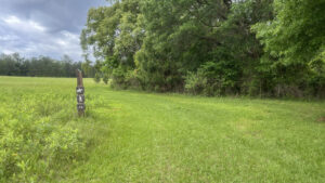
 Trail marker along a dirt road
Resources





Disclosure: As authors and affiliates, we receive earnings when you buy through our links. This helps us provide public information on this website.
Overview
Location: Tallahassee
Length: 21 miles of trails
Trailhead: 30.44407, -84.17522
Address: 2500 Pedrick Rd, Tallahassee
Fees: Free
Restroom: Portable toilet at trailhead
Land manager: Leon County
Phone: 850-606-1470
Open sunrise to sunset. Leashed dogs welcome. Cyclists and hikers must yield to equestrians.
Directions
From the Interstate 10 exit for US 90 (Mahan Ave) east of Tallahassee, follow US 90 west for 1.4 miles to Pedrick Rd. Make a left at the light and continue along Pedrick Rd, going straight at the single traffic circle. Pedrick Rd ends after 2.5 miles by becoming the unpaved entrance road into the trailhead of the greenway.
Hike
There are two primary loops marked across the J.R. Alford Greenway: the Bluebird Trail and the Alford Loop. Rough maps for both are posted at the trailhead.
What isn’t as obvious on the map is this trailhead is also the eastern access point for Lafayette Heritage Trail Park.
 Welcome sign
Lafayette Heritage Trail
Our reason for our first visit to J.R. Alford Greenway was to visit the Canopy Walkway on the Lafayette Heritage Trail.
A well-worn path leads across the grassy expanse from the trailhead and its portalet towards treeline, entering a decidious forest after 0.2 mile.
 Follow the well-worn path to the Lafayette Heritage Trail
Continue through the woods another 0.4 mile to a signposted trail junction with map, marking the start of Lafayette Heritage Trail Park.
Straight ahead is the start of a broad boardwalk leading to a bridge over the railroad tracks that separates J.R. Alford Greenway from the shores of Lower Lake Lafayette.
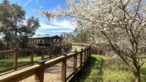
 Start of the Canopy Walkway
A gentle rise to a covered brudge, the boardwalk tops out at a view of Piney Z Lake from the top. Lush bromeliads and mosses decorate ancient live oaks below.
The walkway descends with slight curves into the tree canopy, taking a great deal of distance to reach the forest floor.
 One of the more popular features on the Lafayette Heritage Trail is its Canopy Walkway
Once at ground level, the path is as broad as a forest road. Walk through a small stretch of forest that opens up onto East Levee, a worthwhile destination.
From the middle of the levee, enjoy a panorama of the expanse of Piney Z Lake and Lower Lake Lafayette. This scenic round-trip to East Levee from the Alford trailhead is 2.5 miles.
 Crossing East Levee
Bluebird Trail
A 3.8 mile loop marked with blue arrows, the Bluebird Trail is the shorter of the two loops on the peninsula.
Crossing grassy open hills edged with patches of blackberries and vast expanses of dog fennel, its first 1.2 miles counterclockwise are shared with the Alford Loop.
 The Bluebird Trail starts out along the edges of old pastureland
Once they diverge, it heads for and crosses the central ranch road to loop towards bottomland forests near Alford Arm.
Deep shade and large trees make the northwest corner of the loop the showiest part of the hike. A half mile in this section is also shared with the Alford Loop.
 Turns on the trail are marked with these posts but there are no blazes
Alford Loop
Marked with yellow arrows, the 5.5 mile Alford Loop shares two miles of its route with the Bluebird Trail, most notably a mutual beginning in either direction.
It provides more of a shaded walk thereafter, hugging close to the edges of the peninsula. Occasional views of marshy Alford Arm are possible in several locations.
 Shared section in the shade
Bike
Clockwise, a well-worn track follows Bluebird Trail markers to reach two deeply forested singletrack loops, the 1.3 mile Wiregrass and 1.2 mile Beggarweed Loops.
Pay attention to signage, since the loops are one way, changing direction on different days of the week to minimize erosion.
 Access point to the Beggarweed Loop
Accessed from the trailhead in an obvious downhill extending beyond the entrance road, a network of well-packed doubletrack meanders all over the peninsula.
Take a photo of the map at the trailhead to match markers you find along it with your position for wayfinding.
 Overall trail map at trailhead kiosk
Cyclists can put together any number of routes together using the central maintenance road to reach the extensive array of packed surface roads across the peninsula.
Use a map app or GPS to determine your position relative to the trail markers, each of which sports a unique code on top.
 One of many roads making up the trail system
As we discovered by heading counterclockwise on the Alford Trail, its grassy surface is better left to hikers and equestrians.
Cyclists should instead use the Lafayette Heritage Trail to reach the Longleaf Trail, a 2.5 mile linear route that immediately branches off it to the left.
 The Longleaf Trail peels off the LHT
The Lafayette Heritage Trail crosses the railroad on a canopy walk to enter adjoining Lafayette Heritage Trail Park.
A linear ride on the shared use trail from the Alford Greenway trailhead to Tom Brown Park is 4.1 miles, with more rugged singletrack routes tempting along the way.
 View of Piney Z Lake from the Canopy Walkway
Connected to the greenway but not a part of it, Bill’s Trail starts where the Swift Creek spur peels off to reach a small trailhead along Pedrick Rd.
Follow signage along this rugged, rooty route to make a connection to the West Levee of Piney Z Lake.
 Bill’s Trail
Trail Map

Blue: Bluebird Trail. Purple: Alford Trail. Red: Lafayette Heritage Trail. Black: Bill’s Trail.
Explore More!
Learn more about the Lafayette Heritage Trail.
 Lafayette Heritage Trail Park Hike, bike, paddle, or fish along the well-marked trails of Lafayette Heritage Trail Park in a deeply wooded landscape east of downtown Tallahassee.
Video
Hiking the Bluebird Trail
Slideshow
See our photos from the JR Alford Greenway
Nearby Adventures
 Tom Brown Park Gateway to two notable Tallahassee trails, Tom Brown Park has its own network of trails and a variety of recreation for all.
 Letchworth-Love Mounds Archaeological State Park Tucked in a leafy glade near Lake Miccosukee, Letchworth-Love Mounds Archaeological State Park preserves one of the state's greatest archaeological treasures, Florida's tallest ceremonial mound.
 Ney Landrum State Park Wildflowers bloom throughout the year alongside a series of interconnected trails crisscrossing forested woodlands near the headwaters of the St. Marks River.
 Wacissa Springs One of a vanishing breed of old-time swimming holes within an easy drive of Tallahassee, Wacissa Springs is the birthplace of the Wacissa River and home to more than a dozen springs.

- Hal Scott Yellow Trail - November 3, 2026
- Hal Scott Preserve - October 28, 2026
- Tradewinds Park - October 27, 2026