
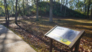
Centered on the Great Mound, an outstanding example of a ceremonial mound, Letchworth-Love Mounds Archaeological State Park is focused on the past.
The grounds include the site of an ancient village near the south edge of Lake Miccosukee, with discoveries in the woods interpreted along the half-mile Weeden Trail.
 An accessible trail leads to interpretive information and the mound itself
Resources




Disclosure: As authors and affiliates, we receive earnings when you buy these through our links. This helps us provide public information on this website.
Overview
Location: Monticello
Length: 0.9 mile loop
Trailhead: 30.52078, -83.99130
Address: 4500 Sunray Rd S, Tallahassee
Fees: $3 per vehicle
Restroom: At the parking area
Land manager: Florida State Parks
Phone: 850-487-7989
Open 8 AM to sunset daily. Leashed dogs permitted. Respect this sacred Native American site by staying on marked trails.
Directions
From the circle in downtown Monticello, follow US 90 west towards Tallahassee for 7.3 miles, passing a pulloff for Lake Miccosukee just before a sign for Leon County. Watch for Sunray Rd on the left. Follow this road a little over a half mile into the park. From Interstate 10 at US 90 in Tallahassee, the turnoff onto Sunray Rd is 10.6 miles east of the interchange.
About the Park
Along both the accessible approach to the Great Mound and the rambling Weeden Trail through the pine flatwoods, the tale unfolds of a culture from 500 A.D., the Woodland Period.
The mound is more than a thousand years old. The Weeden culture of that period is named for a pottery style found by archaeologists at Weedon Island near St. Petersburg in the 1920s.
 Illustration of mound building
Inside the picnic shelter a short distance from the parking area, a timeline illustrates the context of this culture against other major cultures discovered in Florida.
Continue a short walk along the paved path along the base and up to an overlook to view the Great Mound up close.
 An observation deck is at the base of Great Mound
The Weeden Trail starts in a clearing just past the observation deck. Clearings along it illustrate other mounds throughout the pine woods.
The site of a village, the mound and these clearings aren’t far from Lake Miccosukee, a likely food source and travel route for early peoples.
 Nearby shore of Lake Miccosukee
Hike
Start your walk by following the walkway from the parking area to the picnic pavilion, which has a three-dimensional model of the mound and an illustrative panel.
The trail arcs past a kiosk and then the mound itself, with interpretive markers along the pathway.
 Walking to the Great Mound
Reach the observation deck at Great Mound after 0.2 mile. Scramble up for a view of the ceremonial mound, which is being cleared of vegetation to restore its features.
Just past the deck is the start of the Weeden Trail, a level path into the pine flatwoods.
 Weeden Trail sign
Walk straight down an alley of towering loblolly pines to a mound in a clearing, thought to be the location of village homes elevated over a marsh.
Blazed blue, the pathway makes a sharp left here. Since there are unmarked side paths, it’s important to pay attention to the low trail markers and blazing.
 Village mound
The broad path leads beneath tall pines, passing under the shade of live oaks as it edges a floodplain forest along a curve.
Under the outstretched limbs of two massive live oaks, a bench overlooks an ephemeral marsh in the floodplain.
 Little wetland in the woods
Curve past a path branching to the left through the dense thicket of undergrowth shaded by the high tree canopy.
Emerge into a more open sandhill dominated by the towering loblolly pines.
 Floodplain forest in winter
Edge past another stretch of floodplain forest, maples and sweetgum visible beyond the oaks lining the footpath.
The path broadens past a large oak, emerging into an open area where young pines grow in the leaf litter surrounding a bench.
 Large oak at a curve
Winding through the forest, the trail emerges into another large clearing with a visible mound.
Reaching the edge of the forest, it simply ends. Walk straight ahead to the picnic pavilion. Exit to the parking area to complete your not-quite-a-mile hike.
 Carolina jessamine cascading along the trail
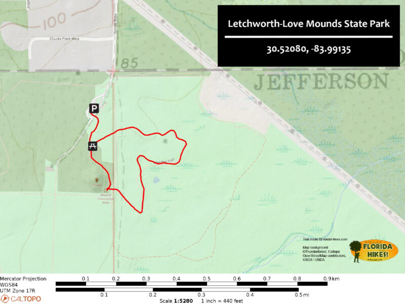
Trail Map
Explore More!
Video
A virtual walk through Letchworth-Love Mounds State Park
Slideshow
See our photos of Letchworth-Love Mounds State Park
Nearby Adventures
More worth exploring while you’re in this area.
 Wacissa Springs One of a vanishing breed of old-time swimming holes within an easy drive of Tallahassee, Wacissa Springs is the birthplace of the Wacissa River and home to more than a dozen springs.
 J.R. Alford Greenway Preserving a peninsula in the Lake Lafayette basin for recreational use, the J.R. Alford Greenway is the eastern gateway to the Lafayette Heritage Trail.
 Lafayette Heritage Trail Park Hike, bike, paddle, or fish along the well-marked trails of Lafayette Heritage Trail Park in a deeply wooded landscape east of downtown Tallahassee.
 Alfred B. Maclay Gardens State Park Explore a true Tallahassee treasure on gentle garden paths amid plantings dating back to 1923 or along well-trodden trails into wild woodlands along Lake Hall and Lake Overstreet.

- Hal Scott Yellow Trail - November 3, 2026
- Hal Scott Preserve - October 28, 2026
- Tradewinds Park - October 27, 2026