
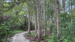
Named after a type of Cracker cattle that would have been found on the land a hundred years ago, Peghorn Nature Park and Trail offers an immersive experience into a 19th century outpost with a blacksmith forge, cannery, and old schoolhouse.
Beyond the village, a well-maintained system of crushed shell pathways wind through dense forests and wetlands, crossing boardwalks along the way.
 Trailhead Center
Resources



Disclosure: As authors and affiliates, we receive earnings when you buy through our links. This helps us provide public information on this website.
Overview
Location: St. Cloud
Length: 1.2 miles
Trailhead: 28.239417, -81.303250
Address: 2101 Peghorn Way, St. Cloud
Fees: Free
Restrooms: In the nature center
Land manager: City of St. Cloud
Phone: 407-957-7243
Open Monday – Saturday, 8:00 AM – 6:00 PM. Leashed dogs welcome.
Directions
From the intersection of Florida Ave and US 441 near the center of St Cloud, head south on Florida Ave for 0.2 mile before turning right onto 17th St. In 1.2 miles, make a left onto Budinger Ave, then take a right onto Peghorn Way in 0.2 mile. The parking area will be on the left in a tenth of a mile, after passing the entrance to the park. Accessible parking spots are available directly in front of the Trailhead Center.
Hike
Starting in front of an old home repurposed as the Trailhead Center, enter the building and walk through, admiring shelves adorned with artifacts and books.
As an alternative to entering the front of the house, follow a concrete sidewalk around the side of the building, where an accessible ramp ascends to a door at the back.
 Inside the Trailhead Center
This sidewalk branches at the beginning of the loop trail, heading westward past a nursery and through the old schoolhouse.
To the east, the sidewalk leads to the blacksmith forge and chicken coop.
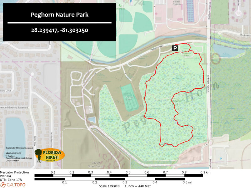
Beginning the hike in a counterclockwise direction, head west from the old schoolhouse, and look for a sign designating the start of the trail.
 Historic schoolhouse
Passing a pair of benches near the start, following a crushed shell corridor as it weaves through a shady canopy of cypress and oak.
Reaching an intersection with the Orange Trail and a boardwalk at a quarter mile, continue straight to follow the Blue Trail deeper into the park.
 Bald cypress
Ferns and blackberry brambles line the trail, alongside loblolly bay and lyonia covered in grape vines.
At 0.7 mile, a side trail marked with green arrows takes a quick dive into a hardwood hammock.
The main path continues straight to an eastern junction with the Orange Trail.
 Bench on the green loop
At this intersection, turn right to cross a wetland filled with willows, red maples, and sweetbay magnolia on a lengthy boardwalk.
At the other end, the trail emerges alongside an open pond with an observation deck.
 Wetland boardwalk
The Orange and Blue trails diverge again next to the pond, with the Orange Trail leading across a small bridge at the water’s edge.
The Blue Trail crosses the Rainbow Bridge, a memorial for lost animal companions.
The concrete sidewalk begins beyond the Rainbow Bridge, curving past a chicken run before ending at the Trailhead Center.
 Rainbow Bridge
Trail Map
Explore More!
Video
Hiking Peghorn Nature Park
Nearby Adventures
 Lake Runnymede Conservation Area Ancient live oaks provide a tightly knit canopy over the 0.9-mile trail system at Lake Runnymede Conservation Area, a 43 acre urban preserve.
 Lake Lizzie Marsh Loop In the most accessible corner of the thousand acres that make up Lake Lizzie Conservation Area in St. Cloud, the Marsh Loop is an easy 1.7 mile hiking-only loop.
 Lake Jackson Tower Trail A short but scenic hike, the ramble to the Lake Jackson Tower at Prairie Lakes pays off with panoramic views from atop a three-story tower.
 Cherokee Point Conservation Area Protecting a marshy peninsula on the eastern shore of Lake Tohopekaliga, this remote preserve provides a panorama of natural wetlands from its boardwalk.

- Oscar Scherer Green Trail - November 11, 2026
- Sandhill Preserve - November 9, 2026
- Calusa Heritage Trail - November 5, 2026