
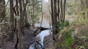
On the state line southwest of Cantonment, the Perdido Riverwalk surprised us with its scenery. We weren’t expecting much given its location behind the Escambia County landfill.
The access road leads past the landfill and the sheriff’s shooting range, but neither impacted the trail on our visit. The drone of traffic does, since Interstate 10 is near.
It’s an older trail, and its infrastructure could use updating, but a worthy destination for the steep terrain and beauty of the river frontage on the Alabama state line.
 Side channel on the Perdido River
Resources




Disclosure: As authors and affiliates, we receive earnings when you buy through our links. This helps us provide public information on this website.
Overview
Location: Cantonment
Length: 0.7 mile loop
Trailhead: 30.575905, -87.406800
Address: 13011 Beulah Rd, Pensacola
Fees: Free
Restroom: None
Land manager: Escambia County
Phone: 850-937-2160
Open Mon-Sat 7 AM-5 PM. Leashed dogs welcome.
Directions
From Interstate 10 exit 5, head west on Alt US 90 (Nine Mile Rd) for 2.9 miles. Turn right on Beulah Rd and drive north 3.5 miles. Turn left on the main road through the landfill/recycling complex and continue 0.7 mile. The road turns to dirt past the shooting range; it ends in an enormous lot. Park along the southern edge.
Hike
Starting at the Perdido Riverwalk signs at the southwest corner of the parking area, follow the adjoining path into the woods.
Dominated by tall laurel oaks and towering pines, the forest is a climax sandhill with a relatively open understory.
 The bluff on the horizon is in Alabama
Cross a wooden footbridge before the trail suddenly plummets downhill. Club moss rises from seepage slopes. Narrowing, the path reaches the base of the river bluff.
An old boardwalk with a faded “Walk of Honor” plaque affixed to a plank at its start stretches across a basin crowded with titi.
 Boardwalk across titi-lined tributary
At its far end, join a berm beneath enormous pines and cross a bridge. Light streaming through the trees suggests the Perdido River is near.
Passing numbered posts in a narrow passageway through the understory, cross a second bridge. Traffic noise increases as you reach a bench and beyond it, a boardwalk.
 River floodplain
A quarter mile into the loop, a boardwalk guides the trail along a gum swamp edging an side channel of the river. Open water is visible at a curve.
The boardwalk ends, and you can walk to the water’s edge for a good view up the channel.
 Boardwalk to the river’s edge
Paralleling the Perdido River, walk through its bluff forest, the open understory affording river views. The view opens up where a split-rail fence marks a dropoff along the bluff.
Past a bench, cross a substantial footbridge over a creek flowing into the river. Beyond the next bench, join a a leaf-strewn forest road.
 One of many river views from the banks
At 0.4 mile, the trail curves away from the river. Now it’s heading due east, paralleling Interstate 10.
Follow the narrow two-track beneath towering pines past another bench. At a sharp left in the forest, the interstate recedes behind you.
 Forest road
Deeply carpeted in pine needles, the road is pleasant to walk on, gently jogging around clumps of saw palmetto.
Signage to the right reminds you of the proximity of the sheriff’s compound.
 Dipping through the swale
After passing through a low clay swale at 0.6 mile, the trail curves uphill into the climax sandhill forest and straightens.
A line between clay and trees in the distance becomes sharper on the approach: the parking area. Emerge at its southeast corner to walk to your vehicle, completing a 0.7 mile loop.
 Approaching the parking area
Trail Map

Explore More!
Video
A walk through the Perdido Riverwalk
Slideshow
See our photos from this hike
Nearby Adventures
 Perdido Bay Trail Traverse a loop through coastal forests at Tarkiln Bayou Preserve State Park, featuring sweeping views of Perdido Bay and a dynamic mix of wet and dry ecosystems.
 Edward Ball Nature Trail Circle the Thompson Creek floodplain beneath the shade of tall cypresses on this nature trail loop on the edge of the University of West Florida campus.
 Navy Point Linear Park Defining the waterfront of a historic residential community, Navy Point Linear Park offers a recreation corridor across Bayou Grande from Naval Air Station Pensacola.
 Garcon Bayou Nature Park On 18 acres along Garcon Bayou, a boardwalk with freshwater wetland and brackish bayou views attracts birders to a small nature park with picnic pavilions and playgrounds.

- Michael Crotty Bicentennial Park - November 3, 2026
- A.J. Henry Park - November 1, 2026
- Okeeheelee Nature Center Trails - October 22, 2026