
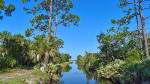
Pine Island is for the birds, or so you’d think on a winter visit amid all the chatter and flutter. As a popular birding site, we’d expected them, along with alligators
More surprising was a dolphin racing up the main channel and the litter of horseshoe crabs along the shore. Manatees delight, too, within Sams Creek.
 Dolphin pacing our hike
Protecting 880 acres of frontage on the Indian River Lagoon, it is a mix of salt marshes and mangrove forest with ridges of pine flatwoods and palm hammocks.
There are bluffs along the lagoon and Sams Creek, too. However, man-made bodies of water—borrow pits, canals, and ditches—dominate.
 Salt pond
These make for a puzzle of a trail network that often seems to loop back on itself. Individual trails range in distance from a quarter mile to 5.8 miles.
The distance you can tally depends on trail conditions and current closures. The showiest paths to the lagoon are fragile after storms.
 Hurricanes erased this waterfront path to an Audubon lookout point
In addition to hiking, off-road biking and equestrian use are permitted on some trails. Trails limited to hiking are posted.
From a well-marked launch, a signposted paddling route also follows Sams Creek and interior ponds, with portages over the hiking trails.
 Paddlers in Sams Creek
A platform on Sams Creek encourages manatee watching, and one very short boardwalk ends at a secluded bird blind amid the mangroves.
Open to fishing, the shorelines of North Lake and South Lake also make splendid places to set up a camp chair to watch daytime rocket launches.
 Angler along North Lake
Resources





Disclosure: As authors and affiliates, we receive earnings when you buy through our links. This helps us provide public information on this website.
Overview
Location: Merritt Island
Length: Up to 10.3 miles
Trailhead: 28.4925, -80.7214
Address: 2100 Pine Island Rd, Merritt Island
Fees: Free
Restroom: At Sams House
Land Manager: Brevard County
Phone: 321-449-4720
Open 8:30 AM. Day use only; exit before the gate is locked at dusk. No pets.
Mosquitoes can be fierce. Alligators are common; be aware of your surroundings.
At a separate entrance at 6195 North Tropical Trail, Sams House interprets the oldest homestead in Brevard County, a cabin from 1875 as its centerpiece.
Gentle trails provide hands-on activities ideal for young children. Its nature trails interlink with the Garnet Trail. Sams House is open Tue-Sun, 9-5.
Directions
Exit Interstate 95 at SR 50 in Titusville and follow it east briefly to the first traffic light. Turn right on SR 405 and drive 10 miles to Kennedy Space Center. Turn off NASA Causeway to pass the visitor center entrance and the Blue Origin complex along Space Commerce Way. At SR 3 turn right and continue 2.8 miles to Pine Island Rd. Turn right and follow it 2.5 miles to where it ends at the preserve. Parking is unpaved and unmarked. Most visitors park on the left just inside the gate near the kiosk. The Sams Creek launch has a larger parking area; follow signs on the left to reach it. Parking is also possible up the road along North Lake where it meets a guardrail and ends.
Hike
A network of trails radiate from the trailhead kiosk although it’s not obvious at first glance. Two giant borrow pits, now man-made lakes, flank the entrance.
It’s thought their contents may have contributed to building launch pads at nearby Cape Canaveral.
 South Lake south of the parking area
Straight ahead is a continuation of the entrance road behind a gate, paralleling the canal the fill was removed from to make a causeway into a mangrove swamp.
Start your exploration by walking that causeway along the canal. Alligators sun in low spots beneath white mangroves, while wading birds stalk the water’s edge.
On the left are mud flats in a mangrove swamp. A flash of pink heralds the presence of roseate spoonbills feeding.
 Starting point for this hike
Passing a bench set under a tree in this otherwise sunny corridor, note a ditch perpendicular to the canal.
Near the half mile mark, the canal broadens into a large pond busy with bird life. PVC posts mark the paddling trail crossing it. Where it narrows to a canal again is the bridge.
Just before the bridge, a shaded bench adjoins a trail junction with a map for the Flatwoods Trail.
Skip this entrance to it and walk up past the bridge to the Indian River Lagoon.
 Trail junction
Persistent storms have ruffled the lagoon’s normally placid waters and undercut the shoreline. What remains of the former loop edges the eroding shore under cabbage palms.
Seagrass creates a wrack line dotted seasonally with the shed shells of horseshoe crabs. This trail looped to the Flatwoods Trail previously but was permanently closed off on our last visit.
A brief round-trip along what remains of it provides excellent perspectives of this natural coastline along the lagoon.
 Debris and undercutting destroyed the footpath
Return the way you came to the Flatwoods Trail junction and turn right. Now a round-trip, this trek leads through a healthy coastal flatwoods with scattered larger longleaf pines.
It’s a comfortable, easy walk, the footpath well-defined like a hallway through the dense understory of the pine flatwoods.
 Flatwoods Trail
A pair of bald eagles nest in one of the tallest pines to the west; their cries echo across the landscape.
At the junction, the trail to the right may still reach the lagoon’s edge for good views. Straight ahead is another scenic spur, the Little Inlet Trail.
 Trail junction
Dipping through a palm hammock with a sometimes-soggy slough across it, it reaches a sharp right to follow a narrow piece of high ground between the mangroves.
Trail’s end is at a very pretty cove on the lagoon, lined with red mangroves. Shallow mud makes it a feeding ground for roseate spoonbills and other wading birds.
 Little Inlet
Retrace your steps along the Little Inlet Trail and past the Flatwoods Loop junction along the gently undulating Flatwoods Trail.
Reach the trail kiosk again, tallying at least 2.3 miles so far exploring the trails south of the canal.
 Returning to the Flatwoods Trail
To add another worthwhile spur, cross the bridge over the canal and make an immediate left onto the Shoreline Trail.
This one is a scenic round-trip to a viewpoint along the lagoon, paralleling the north side of the canal along a high berm and a dip through a marsh.
Pop out at a bench on the lagoon overlooking the expanse across to Port St. John.
 Canal meets lagoon
Like its counterpart south of the canal, this trail used to follow the shoreline north and was by far the most scenic hike in the preserve, but was damaged by storms.
The round-trip on it is now 0.4 mile. Crossing the bridge, a direct return to the trailhead along the canal makes for a 3.2 mile hike. Or, keep going!
 Bridge over the canal
Referred to as the Equestrian Trail on preserve maps, the North Loop extends from the bridge to the north end of North Lake, with a spur out to the lagoon.
At a minimum, follow the curve past the turnoff for the Shoreline Trail to the portage for the canoe trail, a nice overlook at the inner pond on the canal.
 Salt pond with white pelicans
Around the next bend is a sweeping panorama of a much larger salt pond where we’ve seen flocks of white pelicans in winter.
The trail makes a 90-degree turn and narrows, running along the opposite side of the canal that the access trail followed to the bridge, but without views.
 Palm-lined path
The next 90-degree turn sweeps it due north between two canals. Peer between the palms on the left for another overlook on a salt pond.
Reaching a T intersection at 4.6 miles, make a left for a 0.7 mile round-trip to the lagoon paralleling Pine Island Creek.
 North spur to lagoon
This spur narrows past the next portage point to a path adjoining a waterway, ending at a sometimes-mucky mangrove-lined point along the lagoon.
Retrace your steps to the T intersection and walk past it. The trail pops out into the open at North Lake at 5.4 miles.
 Creek meets lagoon near the end of the North Spur
At this junction, the Equestrian Trail continues straight ahead to loop the lake. Make a right instead to follow the near shore.
One of the largest buildings on the planet, the Vehicle Assembly Building at Kennedy Space Center looms over the pines on the far shore.
 Vehicle Assembly Building
Below the berm that holds back the lake from the mangrove swamp, Pine Island Creek glimmers through breaks in the mangroves and cabbage palms.
Reach the guardrail blocking vehicle access from the northern reaches of North Lake at 6.2 miles. The open area beyond it makes for an alternate parking spot for this trail system.
 Pine Island Creek
Following the access road around the curve, pay attention to an opening in the vegetation on the right for the Bird Blind Trail, a quarter mile round-trip to the edge of a natural pond.
It slips off the berm and under the pines before a sharp turn leading between two marshes.
 Bird Blind Trail
The boardwalk between them enters a tunnel shaded by mangroves, curving before popping out at the blind.
The blind is up a couple steps and overlooks open water surrounded by mangroves. Return the same way along the narrow boardwalk.
 The bird blind, camouflaged by shadows
Back on the access road, pass the incoming loop of the Equestrian Trail at the water pumping station as well as the causeway where you started.
Reach the kiosk at the parking area by 6.8 miles. There is one more trail to follow, should you choose to keep hiking.
 Pass the kiosk and continue towards South Lake
The Garnet Trail makes a round-trip along the west side of South Lake to the trail network at Sams House. Starting out in full sun, it follows the access road towards the launch.
However, it continues straight ahead to slip around the guardrail. A broad view of South Lake dominates, birds coming and going from its mangrove islands.
 Garnet Trail
Hiding behind the low vegetation on the right is Sams Creek, not obvious unless yakking paddlers call your attention to it until a bridge.
Take the beaten path to the right to visit the creek’s edge. South of the bridge, the mangroves grow much taller, obscuring Sams Creek entirely.
 Side trip to Sams Creek
The access road curves along South Lake. After a particularly sharp curve, watch for a sign on the right at 7.6 miles stating Sams House is 0.9 mile ahead.
The Garnet Trail enters the mangrove forest on a narrow boardwalk. At a palm hammock, make a sharp turn along a pond fringed with giant leather fern.
 Boardwalk meets berm
Take the signs warning about alligators seriously as there are alligator slides across this berm.
Continue into an oak hammock with a thick understory of cabbage palms and cross a bridge over a ditch.
 Bridge to the Hammock Loop
Meet the north end of the Hammock Loop at 8.2 miles. It’s the showiest natural path in the trail network at Sams House.
Take the right fork and do the loop along with the Lagoon Trail spur out to one last overlook on the lagoon. That circuit adds another half mile to the hike.
 Lagoon Trail overlook
Detailed separately, the gentle nature trails of Sams House tally 1.4 miles on their own.
 Sams House at Pine Island A delightful immersion into the natural side of Merritt Island, the trails at Sams House at Pine Island range from mild to wild as they delve into habitats along the Indian River Lagoon.
Rejoin the Garnet Trail at the north end of the Hammock Loop, emerging onto the grassy berm at South Lake at 9.3 miles.
Follow it along the west side of the lake. If you didn’t park at the launch, walk into the launch parking area.
 Birds roost on the mangrove islands in South Lake
A narrow beaten path just 50 yards long leads through sea oxeye and saltbush to a platform elevated above Sams Creek for manatee viewing.
Leave the parking area to return to the trailhead kiosk, wrapping a 10.3 mile hike on the trail network at Pine Island Conservation Area.
 Viewing platform on Sams Creek
Trail Map

Explore More!
Biking Pine Island Conservation Area
 Biking Pine Island Conservation Area Within sight of the massive Vehicle Assembly Building at Kennedy Space Center, this ride to the Indian River Lagoon offers some of the best birding you'll do by bike.
Video
Hiking a 7.5 mile circuit at Pine Island Conservation Area
Slideshow
See our photos of Pine Island Conservation Area
Nearby Adventures
 Kings Park A mosaic of landscapes disturbed by past development now lush with vegetation, Kings Park protects both freshwater and brackish waterways with a ribbon of bike path between them.
 Pioneer Paddling Trail Amid mangrove swamps along an old pioneer route in Kings Park, the Pioneer Paddling Trail offers an intimate look at a forgotten wild corridor on Merritt Island.
 Paddling the Thousand Islands One of the hidden natural treasures of Cocoa Beach, the Thousand Islands provide a fun paddle through a maze of mangroves on a marked trail through a conservation area.
 Enchanted Forest Sanctuary It's not rocket science: the first and finest of the Brevard Environmental Endangered Lands, Enchanted Forest Sanctuary in Titusville is a fabulous destination for family hiking.

- Hal Scott Red Trail - November 13, 2026
- Baseline Trails - November 7, 2026
- Hal Scott Yellow Trail - November 3, 2026