• Skip to main content
  • Skip to header right navigation
  • Skip to after header navigation
  • Skip to site footer
Florida Hikes logo

Florida Hikes

Hike Bike Paddle Camp Florida with authors Sandra Friend and John Keatley as your guides

  • Trails
  • Maps
  • Guidebooks
  • Hike
    • Scenic Hikes
    • Loop Trails
    • Dog-friendly Hikes
    • Hikes for Kids
    • National Parks in Florida
    • Florida State Parks
  • Bike
    • Major Bike Trails
    • Paved Bike Trails
    • Off Road Biking
    • Biking Articles
  • Paddle
    • Canoe & Kayak Rentals
    • Paddling Destinations
    • Paddling Articles
  • Camp
    • Cabin Rentals
    • Car Camping
    • Primitive Camping
  • Florida Trail
    • Plan your Hike
    • Best Scenic Hikes
    • Best Backpacking
    • Section Hiking
    • Thru-Hiking
    • Trail Updates
  • Travel
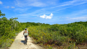
Sandra biking in mangroves

Port Bougainville Trail

At Dagny Johnson Key Largo Hammock Botanical State Park, enjoy the island’s bounty of National Champion tropical trees from the 2.4 mile loop of the Port Bougainville Trail

Key Largo (25.1761, -80.3695)   2.4 miles   Key Largo Hammock Botanical State Park

The Port Bougainville Trail is a loop you can hike or bike to explore the frontcountry of this 2,500-acre preserve. About half of it is easy, while the rest is rugged and tricky to follow in spots.

It provides overlooks into the quarries dug in the middle of the tropical forest, and rugged coral rock to wander over into tidal flats.

Coastal prairie John scouting along tidal flats in a coastal prairie


On our attempt to do the loop, the tidal flats and quarry were too innudated to ride across. Be mindful of tide charts and water levels in Key Largo.

The fact that there is a “Half Loop” option lets you still explore a minimum of a 1.2 mile loop even when conditions don’t work for the full loop.


Resources

Resources for exploring the area

Hikers Guide to the Sunshine State book cover South Florida Explorers Guide book cover 50 Hikes in South Florida book cover
 
Disclosure: As authors and affiliates, we receive earnings when you buy these through our links. This helps us provide public information on this website.


Overview

Location: Key Largo
Length: 2.4 mile loop
Trailhead: 25.1761, -80.3695
Address: CR 905 & MM 106, Key Largo
Fees: $2.50 per person at honor box. Includes per-person Monroe County surcharge
Restroom: Composting toilet
Land Manager: Florida State Parks
Phone: 305-451-1202

Open 8 AM until sunset daily. Leashed pets and bicycles welcome.

Stay on the pathways! Avoid biking down narrow side trails and do not bushwhack.

There are poisonwood and machineel trees throughout the hammock, both of which can cause severe reactions for anyone allergic to poison ivy.

Expect insects no matter the time of year. Always use mosquito repellent. We were advised by an FWC officer not to do this trail during the summer months due to the ferocity of the biting insect population.

As this is a botanical state park, no mosquito control spraying is done here, unlike throughout most of the Florida Keys.


Directions


Driving north on US 1 from John Pennekamp Coral Reef State Park, keep right at the fork for SR 905 (to Card Sound Rd). The trailhead parking area is on the right after 0.5 mile, in front of a large archway.

Hike

Park next to the archway and follow the pavement into the woods, stopping at the iron ranger to pay your state park entrance fee.

If you’re wondering about the strange look of this entrance, welcome to the Port Bougainvillea that never was, a 1980s condo development that collapsed.

Archway at trailhead The old condo entrance


Fortunately, it failed just in time for the state to swoop in and save this incredible botanical wonder before much bulldozing started.

The trail curves past a composting privy, and reaches a major intersection in the pavement, with an island of planted trees and a picnic shelter in the middle.

Picnic area The picnic area marks the start of the loop


It’s here you see the first Port Bougainville Trail sign. Turn right.

Pay attention to the plant identifications and notice the differences between the trees, although they seem to blend together on both sides of the old road.

Dense tropical understory There are many types of trees in this hammock


Not far off into the woods in this section are the grand champion roughleaf velvetseed and boxleaf stopper, at 17 feet and 19 feet, respectively.

Of the all of the grand champion trees in the hammock, few of them reach 30 feet tall—the 34-foot blolly being a notable exception.

Bench and stone wall Bench at start of Nature Trail


As you pass a bench to the start of a stone wall on the left, watch for a break in the wall at a quarter mile.

That’s the Nature Trail, which meanders off into the hammock and is not open to bicycles. Pass that by and stay on the paved path.

Pavement ends The pavement ends but the trail continues


As open sky appears ahead, the pavement ends. Continue along a rough limestone path through a disturbed piece of tropical hammock. Arrows mark the route.

The forest closes in again, providing dappled shade, and you can see one of the quarries through the trees to the left.

Half Loop junction The Half Loop junction decision point


At a junction with a “Half Loop” sign, continue straight ahead, following the “Full Loop” sign.

A side trail to the left soon after led to a view of the quarry where a ramp once crossed to the opposite side but was now under water.

Rock pile and water Pile of rocks along the quarry crossing


Past this stop, the trail leads out of the tropical forest onto a rocky berm on the edge of a coastal prairie.

Making a sharp left at a T with an “Area Closed” sign to the right, the trail started to parallel a mangrove swamp.

Sandra on bike in mangroves Riding into the mangrove swamp


Although the coral rock kept the trail mostly out of the water, salt water lapped up to its edges and created puddles.

Eventually the trail plunged into the salt water at a mile. We walked along it a little trying to figure out where it went next.

Coastal prairie with tidal water Salt water isn’t kind to bike frames


As we were riding our bikes, we chose to turn around rather than try to make our way through an unknown amount of squishy salt flats.

Returning to the “Half Loop” sign at 1.2 miles, we made a right and followed the trail through a tunnel of tropical forest to the other side of the quarries.

Trail junction sign Junction with the Half Loop


At the T intersection with the west side of the loop, make a right.

It’s here we lost the trail again. We think that’s because a “Service Vehicles Only” sign was blocking the route shown on our map.

We turned right at that sign and the path clearly led us into an open area adjoining the quarry viewpoint from the other side.

Sign in trail says Service Vehicles Only Sign in the trail route shown on the map


Searching around this area, we could not find a continuation of the loop through it, just tall grass and trees hemming in social trails.

Turning around, we continued south along the west side of the loop, passing the Half Loop crossover.

Tall grass and no trail We turned around here on the west side of the loop


The trail adjoined another large quarry, this one with a panorama from its shoreline.

Enjoy the views from the edge, but be aware of the poisonwood trees with their black oozy blotches and avoid brushing against them.

Quarry filled with water Limestone was excavated from these quarries long ago


Continuing along, the trail is in the tropical hammock and broadens to the width of a road.

You can hear cars along Card Sound Road, which isn’t all that far from the trail. The trail curves left, and quickly brings you to the picnic table and butterfly garden.

Broad path in tropical forest Broad path on the return trip


Turn right to exit out to the parking lot to complete the trail. Our route, not being able to complete the loop, took 3 miles.

As long as you can traverse the trail (our missing link shown in blue) across the coastal prairie, the outer loop is 2.4 miles.

Paved path adjoined by limestone path in tropical forest Approaching the butterfly garden


Trail Map

Key Largo Hammock Botanical State Park Trail Map
Port Bougainville Trail in red (plus blue section we couldn’t cross)


Explore More!

Learn more about Dagny Johnson Key Largo Hammock Botanical State Park

Tropical hammock Dagny Johnson Key Largo Hammock Botanical State Park A botanical treasure rescued from developers, Dagny Johnson Key Largo Hammock Botanical State Park has the highest concentration of National Champion trees in the United States
Nature Trail in dense tropical forest Key Largo Hammock Nature Trail On the interpretive Key Largo Hammock Nature Trail, tunnel into the largest tropical forest in the United States to enjoy its natural beauty while learning about its unusual trees


Slideshow

See our photos of Key Largo Hammock


Nearby Adventures

More worth exploring while you’re in this area.

Informational kiosk at Crocodile Lake NWR Crocodile Lake National Wildlife Refuge Protecting more than 6,700 acres of Key Largo to provide prime habitat for the endangered American crocodile, Crocodile Lake NWR has a small visitor complex where you can learn about species conservation at the refuge.
Limestone-lined trail in a tropical forest Pennekamp Grove Trail If you've ever wondered where Key limes came from, take a walk on the 0.5-mile Grove Trail at John Pennekamp Coral Reef State Park to see of one of the historic groves of Key Largo.
Bike lane facing Caribbean blue waters in the Florida Keys Florida Keys Overseas Heritage Trail Spanning from Key West to Key Largo, this 108-mile linear state park corridor is an island-hopping slice of tropical paradise along the former route of the Florida Overseas Railroad.
Stone-lined pathway through tropical forest Pennekamp Wild Tamarind Trail Tunneling into the deep shade of the Key Largo Hammock, the Wild Tamarind Trail provides a close-up look at a not-so-common forest.


Official Website

  • Author
  • Recent Posts
Sandra Friend & John Keatley
Articles jointly researched, written, and photographed by Sandra Friend & John Keatley, authors and publishers of FloridaHikes.com.
Sandra Friend & John Keatley
Latest posts by Sandra Friend & John Keatley (see all)
  • Baseline Trails - November 7, 2026
  • Hal Scott Yellow Trail - November 3, 2026
  • Hal Scott Preserve - October 28, 2026
Category: Biking, Day Hikes, Hikes, Loop Hikes, Off Road Biking, Paved Bike Trails, Southeast Florida, TrailsTag: Birding, Botanical, Dog-friendly, Florida Keys, Florida State Parks, Key Largo, Key Largo Hammock State Park

Sidebar

FarOut Guides

Our comprehensive trail logistics presented on offline maps:

Florida National Scenic Trail (1,500 miles)
Florida Keys Overseas Heritage Trail (108 miles)
Eastern Continental Trail in Florida (92 miles)


We earn a small commission on sales through these links. Thanks for your support!


Our Guidebooks

We’ve written Florida guidebooks for over 25 years. These include Southeast Florida destinations.

Book cover with woman hiking through palms with baby carrier
Book cover of Florida Trail Hikes
The Florida Trail Guide fifth edition

Explore More

Newest Articles for Southeast Florida

Emerging from a tunnel of trees to a waterfront Tradewinds Park
Bench at a junction of trails in pine-palm flatwoods Okeeheelee Nature Center Trails
Dense understory beneath pines along footpath Lakewood Regional Park
Silvery-blue saw palmetto Lantana Scrub Natural Area

  • Facebook
  • Flickr
  • Instagram
  • Pinterest
  • Substack
  • Vimeo

FIND A TRAIL OR PARK

METROS: Bradenton. Clearwater. Crestview. Daytona Beach. Destin. Fort Lauderdale. Fort Myers. Fort Walton Beach. Gainesville. Jacksonville. Kissimmee. Lakeland. Melbourne. Miami. Naples. Ocala. Orlando. Panama City Beach. Pensacola. Port St. Lucie. Punta Gorda. St. Petersburg. Sanford. Sarasota. Sebring. Stuart. Tallahassee. Tampa. Vero Beach. West Palm Beach.

MULTI-REGION: Atlantic Coastal Ridge. Atlantic Coast. Bartram Trail. Big Bend. East Coast Greenway. Everglades National Park. Florida National Scenic Trail. Gulf Coast. Lake Wales Ridge. WATERWAYS: Indian River Lagoon. Intracoastal Waterway. Kissimmee River. St. Johns River. Withlacoochee River.

NORTHWEST FLORIDA: Altha. Apalachicola. Apalachicola National Forest. Big Bend Scenic Byway. Blackwater River State Forest. Blountstown. Bonifay. Bristol. Bruce. Cantonment. Cape San Blas. Carrabelle. Chattahoochee. Chipley. Crawfordville. DeFuniak Springs. Eastpoint. Ebro. Eglin Air Force Base. Freeport. Fountain. Gulf Breeze. Gulf Islands National Seashore. Holt. Madison. Marianna. Milton. Monticello. Mossy Head. Munson. Navarre. Navarre Beach. Newport. Niceville. Panacea. Panama City . Perdido Key. Ponce De Leon. Port St. Joe. Quincy. Santa Rosa Beach. Sopchoppy. South Walton. St. George Island. St. Marks. St. Marks NWR. Sumatra. Vernon. Wakulla. Wewahitchka. Woodville. WATERWAYS: Apalachicola River. Blackwater Bay. Blackwater River. Chipola River. Choctawhatchee Bay. Choctawhatchee River. Coastal Dune Lakes. Ochlockonee Bay. Perdido River. St. Marks River. Wacissa River. Wakulla River. Yellow River.

NORTH FLORIDA: Alachua. Amelia Island. Archer. Baldwin. Branford. Bronson. Bunnell. Callahan. Cedar Key. Chiefland. Crescent City. Cross City. Cross Creek. Dowling Park. Ellaville. Fanning Springs. Fernandina Beach. Flagler Beach. Fort White. Glen St. Mary. Green Cove Springs. Hawthorne. High Springs. Inglis. Jacksonville Beaches. Jacksonville Northshore. Jasper. Jennings. Keystone Heights. Lake Butler. Lake City. Live Oak.Macclenny. Mandarin. Mayo. Mayport. Micanopy. Middleburg. Old Town. Olustee. Orange Park. Osceola National Forest. Palatka. Palatka-Lake Butler Trail. Palm Coast. Palm Valley. Perry. Ponte Vedra. Rodman. Salt Springs. St. Augustine. Starke. Steinhatchee. Suwannee. Suwannee River Wilderness Trail. Suwannee Springs. Talbot Islands. Timucuan Preserve. Trenton. Waldo. Welaka. White Springs. Williston. Worthington Springs. Yankeetown. WATERWAYS: Santa Fe River. St. Marys River. Suwannee River. Tolomato River. Upper Withlacoochee River.

CENTRAL FLORIDA: Altamonte Springs. Apollo Beach. Apopka. Astatula. Astor. Auburndale. Bartow. Babson Park. Bayport. Belleview. Bithlo. Brandon. Brooksville. Bushnell. Canaveral National Seashore. Cassadaga. Christmas. Chuluota. Citrus Springs. Clearwater Beach. Clermont. Coast to Coast Trail. Cocoa. Cocoa Beach. Cross Florida Greenway. Crystal River. Dade City. De Leon Springs. DeBary. Deland. Deltona. Dunedin. Dunnellon. Edgewater. Enterprise. Eustis. Ferndale. Fort Meade. Frostproof. Geneva. Gibsonton. Haines City. Hernando. Hernando Beach. Holopaw. Homosassa. Inverness. Kenansville. Kissimmee. Lake Mary. Lake Wales. Largo. Leesburg. Lithia. Longwood. Lutz. Maitland. Malabar. McIntosh. Melbourne Beach. Merritt Island. Merritt Island NWR. Mims. Mount Dora. Narcoossee/Lake Nona. New Port Richey. New Smyrna Beach. Nobleton. Oak Hill. Oakland. Ocala National Forest. Ocklawaha. Ocoee. Oldsmar. Orange City. Ormond Beach. Osteen. Oviedo. Paisley. Palm Bay. Plant City. Poinciana. Polk City. Ponce Inlet. Port Orange. Ridge Manor. Riverview. Ruskin. Safety Harbor. Silver Springs. Sorrento. Spring Hill. St. Cloud. Tarpon Springs. Thonotosassa. Titusville . Umatilla. Viera. Walt Disney World. Weeki Wachee. Weirsdale. Wimauma. Windermere. Winter Garden. Winter Haven. Winter Park. Winter Springs. Withlacoochee State Forest. Withlacoochee State Trail. Yeehaw Junction. Zephyrhills. WATERWAYS: Alafia River. Halifax River. Hillsborough River. Lake Apopka. Little Manatee River. Ochlawaha River. Rainbow River. Tampa Bay. Wekiva River. Wekiva River Basin.

SOUTHWEST FLORIDA: Alva. Boca Grande. Cape Coral. Charlotte Harbor. Ding Darling NWR. Ellenton. Englewood. Estero. Immokalee. Marco Island. North Port. Osprey. Palma Sola. Palmetto. Pine Island. Port Charlotte. Sanibel Island. Venice. WATERWAYS: Caloosahatchee River. Manatee River. Myakka River. Pine Island Sound.

SOUTH FLORIDA: Arcadia. Basinger. Big Cypress National Preserve. Big Cypress Seminole Reservation. Big Cypress Swamp. Bowling Green. Clewiston. Everglades City. Indiantown. LaBelle. Lake Okeechobee Scenic Trail. Lake Placid. Lakeport. Moore Haven. Okeechobee. Ortona. Pahokee. Palmdale. Port Mayaca. South Bay. Wauchula. Zolfo Springs. WATERWAYS: Fisheating Creek. Lake Okeechobee. Peace River.

SOUTHEAST FLORIDA: Biscayne Bay. Biscayne National Park. Boca Raton. Boynton Beach. Coconut Creek. Coral Gables. Coral Springs. Davie. Delray Beach. Fellsmere. Flamingo. Fort Pierce. Hobe Sound. Hollywood. Homestead. Indrio. Jensen Beach. Juno Beach. Jupiter. Jupiter Farms. Key Biscayne. North Hutchison Island. Ocean to Lake Greenway. Palm Beach. Palm Beach Gardens. Pompano Beach. Redland. Sebastian. South Hutchinson Island. WATERWAYS: Florida Bay. St. Lucie River.

FLORIDA KEYS: Big Pine Key. Islamorada. Key Largo. Key West. Marathon. Overseas Heritage Trail.


©2006-2026, Sandra Friend & John Keatley | Disclosure | Site Index | Work with Us | Advertise with Us | Terms of Service and Privacy Policy

Florida Hikes PO Box 93 Mims FL 32754 | Contact