
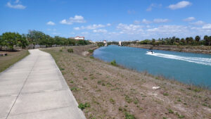
Dug in the 1920s, the Venetian Waterway converted the planned oceanfront community of Venice into an island.
A joint effort between city and county, Venetian Waterway Park provides a greenway with a concrete path along most of what is now the Intracoastal Waterway in Venice.
 Entry to Venetian Waterway Park from Legacy Park
Its two sides are very different. Its north end anchored by the historic Venice Depot, its eastern side is framed as an extension of the Legacy Trail.
Beginning under an archway just south of the Venice Bridge, it extends four unbroken miles south into Shamrock Park, ending at a waterfront connector to that park’s own trail system.
 Riding the trail through Shamrock Park
On the west side, one uninterrupted extends south from a small trailhead below Circus Bridge for 2.4 miles to a back entrance into Caspersen Beach Park.
Mirroring the path on the opposite shore, it is fully in the sun as it glides along a bluff buffered by a thin line of forest from the Venice Airport and adjoining golf course.
 Gopher tortoise along the west side of the waterway
From that same trailhead by the Circus Bridge, the route tacks north from Business US 41 sidewalks to a boardwalk and linear park to the waterway.
Briefly joining the western shore, it circles a neighborhood and ballfield before returning to the bluffs above the water.
 Taking a break in a shady hammock
Passing under the drawbridge at the north end of the island, it terminates by looping around the VABI (Venice Area Beautification Inc) office downtown.
Connecting the east and west sides of Venice Waterway Park requires crossing the Circus Bridge along Business US 41. Our route below outlines a full circuit of the park using that option.
 West side north of the Venice Bridge
Resources



Disclosure: As authors and affiliates, we receive earnings when you buy through our links. This helps us provide public information on this website.
Overview
Location: Venice
Length: Up to 18.9 miles
Trailhead: 27.100666, -82.439078
Address: 303 E Venice Ave, Venice
Fees: Free
Restroom: Legacy Park and Shamrock Park
Land manager: Sarasota County
Phone: 941-486-2626
Open 6 AM to sunset. Leashed dogs welcome. Cyclists yield to other trail users.
Trailheads
Legacy Park, 303 E Venice Ave
Skip Stasko Park, 2101 Scenic Dr
Shamrock Park, 3900 Shamrock Dr
Circus Bridge Trailhead, Airport Ave E
Caspersen Beach Park, 4100 Harbor Dr S
VABI Office, 257 Tamiami Trl N
Trail Details
Venetian Waterway Park Trail East
From the parking area at Legacy Park, head out the entrance and around the south end of the historic Venice Depot to join the paved trail by the waterway.
Pass beneath the Venice Bridge, following the curve back towards the water on the path under the archway for Venetian Waterway Park.
 The archway
Swinging south to parallel the waterway, adjoin a grassy strip atop a bluff along the channel. Boaters frequently zip past.
Oaks and pines and palms buffer the eastern side of the greenway, which backs up to a warehouse district. Work continues to bolster this urban forest with additional trees.
 Urban forest
Gentle curves characterize the path as it weaves within view of a neighborhood on the far shore. A two-track adjoins closer to the bluff.
Passing a bench on a curve, the Circus Bridge, a drawbridge along business US 41, comes into view in the distance.
Its name derives from once adjoining the Ringling Brothers Barnum & Bailey winter circus grounds.
 First distant glimpse of Circus Bridge
Warehouses start paralleling the greenway. The next bench faces a marina on the opposite shore.
A picnic table sits just before a turnoff to US 41 at 1.9 miles. Proceed straight ahead under the bridge.
The greenway narrows, the pathway much closer to the bluff above the waterway. Wooden posts provide a divider between adjoining Scenic Drive and the trail.
 Paralleling Scenic Drive
At 2.3 miles, Skip Stasko Park is on the opposite side of Scenic Drive. It has ample parking and picnic tables but no restrooms.
Scenic Drive diverges where the trail enters the oak-lined frontage of the Senior Friendship Center. A picnic table sits just beyond the oak grove.
 Oak grove in front of Senior Center
A long straight stretch in the sun follows, the land on the left fenced off. The pathway remains close to the bluff’s edge.
Entering Shamrock Park, swoop around a stand of pines with a bench between them. Larger pines characterize the natural habitat at this end of the park.
 Stand of pines
At 3.4 miles, a paved path enters Shamrock Park on the left. Pass it by to stay on the Venetian Waterway Trail.
The trailside habitat becomes scrubbier. A bench overlooks the waterway where two sandy footpaths emerge from the scrub.
 Paved path into Shamrock Park
Pass several more distinct footpaths and sand roads as the landscape becomes open scrub.
Shamrock Park is known for its Florida-scrub jay population, and they might be spotted along this section.
 Open scrub in Shamrock Park
At 4 miles, the large kiosk with picnic tables on a slight hill beyond it marks the end of Venice Waterway Trail East.
Make the short loop around the picnic area to return northbound. Or, take the paved trail into the park to make a circuit within it.
 End of the trail on the east side
Using either route, return to the northerly paved junction with Shamrock Park’s loop at 4.7 miles. Continue north in front of the Senior Center and past Skip Stasko Park.
Reach the Circus Bridge at 6.1 miles. This is your decision point. To simply complete Venetian Waterway Park Trail East, continue straight ahead to Legacy Park, concluding an 8 mile trip.
 Returning under the Venice Bridge to Legacy Park
Cyclists looking to ride the full trail system through Venice all at once, turn right for the ramp up to Business US 41 heading into downtown.
Turn right to cross the Circus Bridge, riding on a wide concrete sidewalk adjoining traffic. This is a drawbridge, so it may require a wait to cross.
 The ramp to Circus Bridge is on its north side
Once on the west end of the bridge, make a hard right at the end of the guardrail to follow the trail back under the bridge to the Circus Bridge trailhead.
If connecting the two sides via the Circus Bridge, add a half mile to the mileages quoted below to start, plus another 2.4 miles at the end to return to Legacy Park for an 18.9 mile ride.
 Underpass on west side of Circus Bridge
Venetian Waterway Park Trail West
While small, the Circus Bridge trailhead provides the best parking option for the west side of the trail system. Downtown parking near the VABI Office tends to fill up.
Start the trip by following the trail southbound. It directly parallels the path on the eastern shore between Circus Bridge and Shamrock Park.
 Circus Bridge trailhead
A slight ribbon of older trees largely buffer the adjoining airfield, which was once a World War II pilot training center, from the park.
A grassy strip adjoins both sides of the concrete path. Watch for gopher tortoises, as there are many active on this side of the waterway.
 Southbound on the west side of Venetian Waterway Park
A collection of burrows is evident in the sand ridge about a mile down the trail, signposted near an old gate into the airport.
Entirely in the sun, this long run along the channel finally passes the airport. A large golf course then sits behind the pines and palms.
 Gopher tortoise area
Meet a bridge into Caspersen Beach Park at 1.6 miles. Devastated by Hurricane Milton, the park had not reopened as of our last visit.
Trail’s end is a tenth of a mile past that turnoff at an overlook along the Intracoastal. Return the way you came to the Circus Bridge trailhead, reaching it at 3.3 miles.
 Underpass past the trailhead
Follow the concrete path under Circus Bridge and turn left. Continue up to the sidewalk adjoining the Tamiami Trail towards downtown.
Passing the marina and a car dealership, watch for a boardwalk on the right just behind a large green road sign at 3.6 miles. Turn right.
 Boardwalk behind the road sign
The boardwalk skims the edge of the car dealer’s lot before emptying into a park. The broad concrete path begins again under a canopy of sand live oaks.
Emerging into a sunny restoration area, the path weaves between fence lines, coming to a T intersection at the waterway at 3.9 miles.
 T at the waterfront
To the right, the concrete path follows the waterway but dead-ends within a tenth of a mile. Add 0.2 miles to this trip if you take that quick detour.
Make a left at the T to parallel the Venetian Waterway north, facing the warehouse district on the far shore.
 Northbound on the west side of the Venetian Waterway
Passing in front of a line of homes looking out over the path and the water, come to a bench outside a park fence.
Curve left at 4.3 miles to leave the waterway, entering the park. There is a picnic shelter in the shade as well as some benches.
 Trailside picnic bench
Becoming a straightaway between fences, the trail meets a series of posts at Golf Dr. Turn right to stay on the concrete path.
Cross the entry road to Country Club Estates at 4.7 miles. The pathway curves through the landscaping past a bench and comes to a stop sign at Green Circle. Proceed after stopping.
 Straightaway between neighborhoods
Slipping behind a Publix shopping center, make another sharp curve to keep rounding Country Club Estates.
A straightaway between chain link fences leads past a bench. A concrete wall rises on the left along a ballpark. Round a corner, face the waterway again at 5.6 miles.
 Returning to the Venetian Waterway
Parallel the waterway north, fences and walls separating the greenway from the athletic complex.
A historic marker commemorates the original Fred Albee Municipal Airport and Dr. Albee’s orthopedic hospital in this vicinity, opened in 1933.
 Trailside murals
Pass under the Venice Bridge at 6.3 miles, the historic Venice Depot clearly visible on the other side of the waterway.
Drawing closer to Roberts Bay and North Venice Inlet, the waterway takes on a more turquoise hue.
 View across to Legacy Park
Keep paralleling the waterway on this final stretch up to the drawbridge at the north end of Venice Island.
Pass below to circle the VABI Office at 6.6 miles. Return back under the bridge and head south, watching for the signs at each jog in the trail.
At 9.3 miles, make the right turn away from the waterway to return to the well-shaded oak canopy and the boardwalk past the car dealer.
 To return to the Circus Bridge from the waterway, turn here
Turn left at the Tamiami Trail sidewalk and follow it back to the Circus Bridge. Take the underpass beneath the bridge to return to the Circus Bridge trailhead at 9.9 miles.
Cyclists returning to Legacy Park: you must cross the Tamiami Trail to ride southbound over the bridge.
Where the boardwalk meets the sidewalk, turn right and go up to the Amora Ave light to do so.
 Boardwalk’s end at the sidewalk
Trail Map

Explore More!
Learn more about The Legacy Trail
 The Legacy Trail Connecting Venice and Sarasota, one of Florida's finest paved trails provides a corridor for biking and hiking along a historic railroad line.
Parks along the Venetian Waterway Park Trail
 Shamrock Park The southern terminus for a greenway spanning from Sarasota to Venice, Shamock Park is a draw for birders with its resident Florida scrub-jays.
 Caspersen Beach Park The southernmost beach in Venice, Caspersen Beach is best known for its bounty of fossil shark's teeth, which people scoop and stoop to dig out of the sand.
Video
Biking Venetian Waterway Park
Slideshow
See our photos from Venetian Waterway Park
Nearby Adventures
 Sleeping Turtles Preserve South Where subdivisions now occupy a formerly sleepy rural corner of Venice, Sleeping Turtles Preserve South provides a haven for wildlife along the Myakka River floodplain.
 Sleeping Turtles Preserve North Named for a feature on old navigational maps, Sleeping Turtles Preserve North provides great views of the Myakka River from its bluffs.
 Curry Creek Preserve East Amid expanding suburbia in Venice, this 71-acre island of botanical delights circled by a 1.6 mile loop buffers wildflower-rich longleaf pine flatwoods along a mangrove-lined stream.
 Deer Creek Prairie Preserve Part of a complex of public lands protecting the Myakka River and its tributaries, Deer Creek Prairie Preserve blankets over 7,300 acres between Venice and North Port.

- Hal Scott Red Trail - November 13, 2026
- Baseline Trails - November 7, 2026
- Hal Scott Yellow Trail - November 3, 2026