
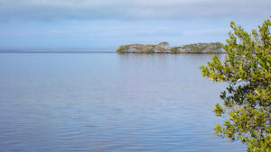
Adding a surprising amount of acreage to Wall Springs Park, the Coastal Addition has two separate trails, extended as land was acquired in four phases.
It fronts Girl Scout Camp Wai Lani and appears to have once been a part of it.
 Its pathways are old roads
A trio of loops follows what feels like old camp roads through native habitats for a 1.2 mile perimeter hike.
A 1.4 mile paved linear trail runs past the parking area. Leading 0.8 mile south to Wall Springs Park, it connects to the Pinellas Trail.
 The paved trail
Northbound, follow it for a 1.2 mile round-trip to observation decks and a tower on Kloisterman Bayou with an outstanding view.
With restrooms, water station, and a large picnic pavilion, the Coastal Addition trailhead provides direct access to both trails for up to 4 miles on foot or by bike.
 Observation decks at the bayou
Resources





Disclosure: As authors and affiliates, we receive earnings when you buy through our links. This helps us provide public information on this website.
Overview
Location: Palm Harbor
Length: Up to 4 miles
Trailhead: 28.114344, -82.772517
Address: 621 Wai Lani Road, Palm Harbor
Fees: Free
Restroom: At the trailhead
Land Manager: Pinellas County
Phone: 727-582-2100
Open 7 AM to sunset daily except the day after Thanksgiving and Christmas. Bicycles and leashed dogs welcome except on boardwalks.
Directions
From the intersection of US 19 and Tarpon Ave in Tarpon Springs, drive south on US 19 for 1.7 miles to E Klosterman Rd. Turn right and continue 1.3 miles to Palm Harbor Blvd (Alt US 19). Turn left and drive south 0.8 miles to Wai Lani Rd. Turn right and continue 0.3 miles to the trailhead on the right.
Hike
Beginning at the trail map sign near the restrooms, take the graveled path on their west side.
Curve into a scrubby flatwoods with tall sand pines and moss-draped sand live oaks above a dense thicket of understory.
 Trailhead
After a tenth of a mile, turn left at a T intersection. The landscape opens up, revealing hurricane damage.
Beyond a thin screen of oak limbs and cabbage palms is a basin of salt marsh with tall pines on its far shore.
 Salt marsh
Curve past sprays of needlerush and a tangle of mangroves. The curve is a constant, scrubby coastal flatwoods on the inside of the loop.
Enter a ghostly stand of pines killed by salt spray, a neighborhood visible beyond them. Pass another glimpse of needlerush marsh.
 Salt-damaged pines
Turning south, a different broad marsh is revealed, this one with greener edges. At 0.4 miles, make a left on a forest road paralleling that marsh.
Slowly ascending, it escapes the salt spray damage zone into a coastal flatwoods with saw palmetto beneath the pines. Gnarled sand live oaks and cabbage palms join the mix.
 Edging the inner marsh
Turning away from the marsh, glimpse another edge of the bordering neighborhood at a half mile.
Although wind-damaged, the canopy of sand live oaks finally closes in. Gnarled, wind-swept branches add visual interest.
 Among the sand live oaks
Turkey oaks signal a shift to sandhills in the northeast corner of the preserve. Wiregrass appears in clearings under groupings of pines.
Mature sand pines tower over large turkey oaks where the understory is smothered in grapevines.
 Sandhills
Another shift occurs as sand pines infiltrate the sandhills, the trail entering a sand pine scrub.
At 0.7 miles, a T intersection enables an immediate return to the trailhead to the right. Turn left instead to stay with the perimeter hike.
 Trail junction
This final section enters a forest with older sand live oaks, reaching a Y junction in a tenth of a mile.
Bear left. Scrub plum and prickly pear cactus rise from a patch of wiregrass amid sand pines.
 Wiregrass patch
The curious mix of sandhills and scrub continues around the loop, with sand pines of significant size above a narrows in the path.
Making a sharp curve, the trail starts west again, entering a forest of mature oaks and pines.
 Taller pines
The archway of sand live oaks signals the end of this loop. Bear left at the Y to the upper loop and continue straight ahead.
Emerge at the east edge of the trailhead, reaching your starting point at 1.2 miles.
 Return to the trailhead
To add a round-trip to Kloisterman Bayou, continue straight ahead to the paved path and turn right.
A set of stanchions keeps vehicles off the trail. Beyond them, curve into the pine flatwoods.
 Paved path to the bayou
The western rim of the vast needlerush marsh seen on the first loop lies beyond them to the east.
Within the pines, skim its edge before crossing a road providing the Girl Scout camp access to the water.
 Paralleling the water
Curving west, draw within sight of a broad waterway, a line of condos on its the far side.
A view of Kloisterman Bayou opens up, with a fishing pier boardwalk and mangrove islands on the horizon.
 Waterfront
The paved path reaches the point, where boardwalks connect roofed observation decks with benches, leading ever higher.
Climb to its high point for a view across the islands where birds gather en masse to roost and nest.
 Mangrove islands
Return the same way along the paved path, a 1.2 mile round-trip back to the Coastal Addition trailhead.
For additional miles, continue to Wall Springs Park through the coastal flatwoods on the paved path. It’s a 1.6 mile round-trip to its parking area.
 Wall Springs Park trailhead
So far, that’s 4 miles. Add more by tackling the accessible trail system within that park, up to another 1.2 miles.
It starts at the far side of the parking area, past the restrooms and playground, as a boardwalk around Wall Springs itself.
 Wall Springs Park Discover the beauty of a historic spring feeding Boggy Bayou and an amazing panorama from an outstanding observation tower on this largely accessible 1.2 mile coastal circuit.
Trail Map

Explore More!
Video
Hiking Wall Springs Addition
Slideshow
See our photos from Wall Springs Coastal Addition
Nearby Adventures
 Pinellas Trail A paved ribbon stretching the length of Pinellas County from St. Petersburg to Tarpon Springs, the Fred Marquis Pinellas Trail provides nearly 38 miles of low-stress cruising.
 John Chesnut Sr. Park Weaving through floodplain forests and cypress swamps, the boardwalks and trails of John Chesnut Sr. Park add a place to pause for wildlife along a wild shoreline on Lake Tarpon.
 Lake Conservation Park A forested escape north of Tampa, Lake Conservation Park features a network of trails where you can loop nearly four miles around a series of small lakes.
 Lake Dan Nature Preserve Two loop trails explore cypress domes and expansive pine flatwoods, while a side trail leads to a sturdy fishing dock over Lake Dan.

- Fort Matanzas National Monument - November 21, 2026
- Carney Island Conservation Area - November 19, 2026
- Hal Scott Red Trail - November 13, 2026