
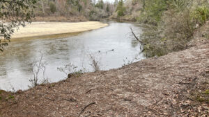
The Perdido River flows swift and tannic in its upper reaches, broad and languid as it approaches Perdido Bay, spilling into Big Lagoon and Bayou St. John at Perdido Key.
A little over sixty miles long, it’s the western border of Florida with Alabama. In its upper reaches, sinuous curves pile up massive sandy beaches in both states.
 Beach along the Upper Perdido River
West of Cantonment along Perdido River Water Management Area, the water is clear and sand-bottomed, a paddler’s delight.
Proving these views by foot, the sometimes-rugged Sand Bar Trail skirts along its beaches and bluffs and nearby ravines to connect Fillingim Landing with Otto Hill Group Camp .
 Climbing out of the Churchhouse Branch ravine
Resources




Disclosure: As authors and affiliates, we receive earnings when you buy through our links. This helps us provide public information on this website.
Overview
Location: Cantonment
Length: 1.9 mile round-trip
Trailhead: 30.675071, -87.405939
Address: 2801 Jacks Branch Road, Cantonment
Restroom: Portable toilets
Land Manager: North Florida Water Management District
Phone: 850-539-5999
Open sunrise to sunset. No overnight camping unless reserved at Otto Hill Group Camp. Leashed dogs welcome. No lifeguards on duty.
Check hunt dates before hiking. Wear bright orange if you hike during hunting season.
Directions
Exit Interstate 10 at Exit 5. Follow Alt US 90 east for 0.4 mile. Turn left on Pine Cone Dr. After 0.6 mile, make a left on CR 297A. Drive 0.4 mile to SR 97. Make a left and continue 4.8 miles to Muscogee Rd. Turn left and in a quarter mile, the road name chages to Jacks Branch Rd. Proceed another 5.8 miles to the entrance for Fillingim Landing. Turn left and follow the dirt road downhill 0.4 mile to the broad parking area at the river landing.
Hike
Walk out to the Perdido River at the launch for views from the boardwalk and platform. Ladders let swimmers to scramble back on top after a plunge into the chilly waters.
Relatively broad and tannic, the river has a massive beach along the curve on the far shore. There’s a red blaze on a tree beyond it, the finale of a hike in Alabama’s Perdido River WMA.
 Platform at Fillingim Landing
Start this hike with a walk to the downriver end of the parking area where a hiker symbol and arrow point towards a beaten path.
Sections of split-rail fence guide the Sand Bar Trail away from the river’s edge immediately due to erosion that collapsed the original route.
 Necessary reroute
Walk above the edge of a floodplain swamp amid cedar and black gum. At a curve, a side path adjoining a fence leads to an overlook on the big sand beach on the far shore.
Another worn path slips to a hidden sandy beach. The main trail straightens out into a linear walk in the woods that feels like an old railroad grade.
 Side path to hidden beach
At a quarter mile, meet a Y intersection at a covered trashcan. Take the right fork. A worn path approaches the riverbank and swings right.
It leads to the largest expanse of sandy beach along the Florida side of the river. Sandbars sometimes surface in this part of the ever-shifting river, hence the name of this trail.
 Sandra on the big beach
Walk the length of this beach and ascend the bluff to the original trail route. Make a right.
Flanked by floodplain swamp and forested sand bluffs, the well-defined footpath loops back to the entry path.
 Start and end of the loop
Turn left to return to the main trail, finishing this scenic quarter-mile side loop a half mile into your walk. Shaded by the bluff forest, the footpath resumes its railroad grade feel.
White blazed, it curves gradually past tall cedars and oaks inside its well-defined tunnel. A greater amount of exposed sand occurs after a sharper turn away from the river.
 Well-graded path among cedars
Reaching a bluff, stairstep down it to cross a wooden bridge over Churchhouse Branch in a deep gully at 0.7 mile. Scramble up roots on the other side.
Winding along the high ground above the gully, note the views downslope. Drop into a former river channel between clumps of saw palmetto before reaching a low point.
 On a bluff above Churchhouse Branch
Flood shadows stain the surrounding trunks of cypresses and black gum. Ascend into the river bluff forest past a stand of magnolias, the river now visible through the screen of trees.
At 0.9 mile, emerge on a bluff above the Perdido River, a long, sandy beach visible on the far shore.
 The far shore is in Alabama
Curving away from the steep bluff, the trail sports blue blazes. Natural overlooks let you soak in the river views.
Leaving the river, the footpath leads past a signposted gate down an old forest road. Watch for an enormous cedar on the left.
 Forest road to the campsite
The Sand Bar Trail ends when you reach the kiosk at 1.1 miles. The adjacent clearing provides parking for registered users of the Otto Hill Group Campsite.
A gate code is required to drive in here. The fenced camping area has picnic benches and grills, a large fire pit, and a nearby portable toilet. A rough, rocky approach to the river from the kiosk serves as a launch and landing.
 Otto Hill Group Camp
For a round-trip hike, this is your turn-around point. Retrace the Sand Bar Trail as you walked it, skipping the quarter-mile loop onto the beach.
Without that extra loop, it’s a 1.9 mile round-trip. But it’s also possible to do this as a linear hike with two cars, even without a reservation at the campsite.
 Old river channel on the return route
For the linear hike, drop one car at the Otto Hill trailhead on your way to Fillingim Landing. Doing so gives you some extra miles on the well-vehicle access road.
It’s all uphill from the campsite, leaving bluff forest for floodplain swamp and then planted pines on the climb. It’s a mile between campsite and trailhead for a 2 mile linear hike.
 The road to Otto Hill trailhead
Trail Map

Explore More!
Learn more about Perdido River WMA
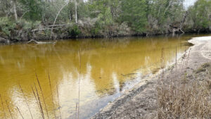 Perdido River Water Management Area Fifteen miles of riverfront public land buffers a sinuous Outstanding Florida Waterway that forms the state line with Alabama at Florida's western border.
Video
A walk through the Sand Bar Trail
Slideshow
See our photos from this hike
Nearby Adventures
 Perdido Riverwalk Walk the banks of the Perdido River after a steep plunge down the bluffs on this short, scenic loop within earshot of Interstate 10.
 Tarkiln Bayou Preserve State Park Conserving a vast swath of wetland habitats in low-lying areas along the Perdido River floodplain, Tarkiln Bayou Preserve State Park is home to four species of Sarracenia - pitcher plants - unique to the Gulf Coast.
 Garcon Bayou Nature Park On 18 acres along Garcon Bayou, a boardwalk with freshwater wetland and brackish bayou views attracts birders to a small nature park with picnic pavilions and playgrounds.
 Big Lagoon State Park Explore a sweep of coastal forest and wetlands along one of Florida's largest lagoons, with panoramas that stretch to Perdido Key and the Gulf of Mexico.

- Michael Crotty Bicentennial Park - November 3, 2026
- A.J. Henry Park - November 1, 2026
- Okeeheelee Nature Center Trails - October 22, 2026