
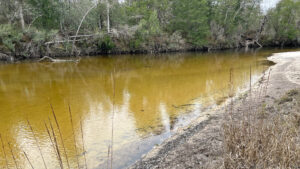
Encompassing 6,261 acres of public land broken into four riverfront parcels, Perdido River WMA is managed by Northwest Florida Water Management District.
Large swaths of it are former pine plantation being restored to natural habitats, but the riverfront and its feeder streams are largely tangled and wild.
 Churchhouse Branch
Massive cedars, magnolia, and oaks crown bluffs; titi forms thickets along tributaries.
The sinuous curves of the blackwater Perdido River allow sand to accumulate at each twist and turn, creating showy white sand beaches that shift over time.
 Beach downriver from Fillingim Landing
Resources




Disclosure: As authors and affiliates, we receive earnings when you buy through our links. This helps us provide public information on this website.
Overview
Location: Cantonment
Fees: Free
Restroom: Portable toilets at landings
Land manager: Northwest Florida Water Management District
Phone: 850-539-5999
Open sunrise to sunset. No overnight camping unless reserved at Otto Hill Group Camp. Leashed dogs welcome.
Directions
Select a destination to pull up directions.
About the WMA
Encompassing 6,261 acres of public land broken into four riverfront parcels, Perdido River WMA is managed by Northwest Florida Water Management District.
Spanning south from Cantonment through Muskogee and Bellview, this water management area includes four landings and a major off-road cycling area as well as equestrian trails.
 Perdido River at The Pipes
We discovered one excellent riverfront hiking trail. Two other trailheads indicated trails existed, but we couldn’t find them based on signs or maps.
The Fillingim Landing Recreation Area is a destination for sunning and swimming along riverfront beaches connected by the well-marked Sand Bar Trail.
Seasonal hunting is permitted, so check the FWC site before planning your trip.
 Bridge along the Sand Bar Trail
Hiking
Otto Hill Trails
Despite the map at the Otto Hill trailhead and the hiker symbol pointing into the woods behind the hiking corral, what you see is not what you get.
This could be due to unresolved wind damage, or showing planned trails on the map that will be established once the landscape is restored.
 A puzzle of pine plantation lies behind the parking corral
The slightly worn path behind the trailhead sign led us into a pine plantation and simply ended, requiring a bushwhack to the road.
A walk on the entrance road from the locked gate at the trailhead to Otto Hill Group Camp was 0.9 mile each way to access the Sand Bar Trail from its southern terminus.
 The road to the group camp descends from pine plantation to river floodplain
Sand Bar Trail
Extending a little less than a mile between Fillingim Landing and Otto Hill Group Camp, the linear Sand Bar Trail shows off the Perdido River from bluffs at both ends.
The middle portion drops through a deep ravine to cross a bridge and scrambles through a floodplain channel. Side trails to sandbars at the north end provide beach access.
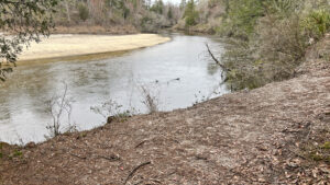 Perdido River Sand Bar Trail Access sandy beaches and swimming holes along the Perdido River on the Florida state line with Alabama along the scenic Sand Bar Trail, a 1.9 mile round-trip in Perdido River WMA.
The Pipes
We spotted a hiker symbol at the entrance to The Pipes and there appeared to be a blazed trail along the upper end of the entrance road heading south into pine plantation.
However, there was nowhere to park to access it, and it headed towards a large clearcut. The road drops off the river bluffs past that point rather precipitously.
 The Pipes Recreation Area is at the river
We found no trail at river level, although a wide spot before some massive permanent puddles in the river swamp was big enough for parking.
The road itself makes an interesting walk. No map was posted at the recreation area to confirm a trail’s existence, nor is a hiking trail shown on the overall WMA map.
 Hiking symbol at The Pipes
Perdido Equestrian Trail
West of Pensacola at 9898 Smallwood Rd off US 90, the four-mile equestrian trail loop is open to hikers as well as riders. Habitat restoration is ongoing.
Blazed yellow, the trail loops out to a picnic table and grill on the Perdido River. A map is posted at the trailhead.
Biking
Developed and maintained by the Pensacola Off-Road Cyclists, the Muscogee Mountain Bike Trails have two access points along River Annex Rd.
It’s an unpaved graded road through rolling terrain that previews the types of rides here. Much of it is in planted pines.
 Typical pine plantation in the WMA
From the northern parking area, the P2C Connector / River Connector make up a direct route to the Perdido River. According to PORG, eight miles of trails are in place with more planned.
Paddling
Fillingim Landing is the northernmost put-in for this WMA. Extend your paddle almost 3 miles by starting where Barrineau Park Rd crosses the river northwest of Cantonment.
 Fillingim Landing
Otto Landing serves as a rest stop, but the takeout is rough and rock-strewn. The water, however, is clear, and it’s a short walk to the picnic pavilion and portalet at the camp.
 Otto Landing
The Pipes is the next recreation area south, which only works as a take-out if you have a 4WD vehicle or a lot of experience driving deeply eroded and sometimes flooded roads.
If not, plan to use this landing as a rest stop while paddling, since it has picnic tables.
 The Pipes Landing
Halfway along the 15.4 mile paddle is Adventures Perdido River, a riverfront outfitter in the old community of Muscogee.
The lower take-out is Sand Landing, off US 90. Add another 2.6 miles by finishing the trip at Wilson B Roberston Boat Launch at the US 90 bridge.
Plan your paddling adventure using the state’s Perdido Paddling Guide.
 River bend as seen from a bluff
Camping
Camping is only provided at Otto Hill Group Camp, which has a large area for tenting interspersed with picnic tables and grills.
A potential launch point for a paddling trip, it can be reserved; using a gate code, campers can drive in and park next to it and its rough launch.
 Otto Hill Group Camp
Hunting
Florida FWC manages hunting in the various units of Perdido WMA. Consult their brochure and map for hunting season dates and locations.
Recreational users should wear bright orange if inside hunting zones during hunting season.
Hunting symbols were shown on signs at The Pipes and Otto Hill but not Fillingim, where visitors come to swim along the beaches and sandbars.
 Hunting symbol posted at Otto Hill trailhead
Overview Map
 Map from Northwest Florida Water Managment District
Explore More!
Video
Our hike on the Sand Bar Trail
Slideshow
See our photos from Perdido River WMA
Nearby Adventures
 Perdido Riverwalk Walk the banks of the Perdido River after a steep plunge down the bluffs on this short, scenic loop within earshot of Interstate 10.
 Tarkiln Bayou Preserve State Park Conserving a vast swath of wetland habitats in low-lying areas along the Perdido River floodplain, Tarkiln Bayou Preserve State Park is home to four species of Sarracenia - pitcher plants - unique to the Gulf Coast.
 Garcon Bayou Nature Park On 18 acres along Garcon Bayou, a boardwalk with freshwater wetland and brackish bayou views attracts birders to a small nature park with picnic pavilions and playgrounds.
 Big Lagoon State Park Explore a sweep of coastal forest and wetlands along one of Florida's largest lagoons, with panoramas that stretch to Perdido Key and the Gulf of Mexico.

- Michael Crotty Bicentennial Park - November 3, 2026
- A.J. Henry Park - November 1, 2026
- Okeeheelee Nature Center Trails - October 22, 2026