• Skip to main content
  • Skip to header right navigation
  • Skip to after header navigation
  • Skip to site footer
Florida Hikes logo

Florida Hikes

Hike Bike Paddle Camp Florida with authors Sandra Friend and John Keatley as your guides

  • Trails
  • Maps
  • Guidebooks
  • Hike
    • Scenic Hikes
    • Loop Trails
    • Dog-friendly Hikes
    • Hikes for Kids
    • National Parks in Florida
    • Florida State Parks
  • Bike
    • Major Bike Trails
    • Paved Bike Trails
    • Off Road Biking
    • Biking Articles
  • Paddle
    • Canoe & Kayak Rentals
    • Paddling Destinations
    • Paddling Articles
  • Camp
    • Cabin Rentals
    • Car Camping
    • Primitive Camping
  • Florida Trail
    • Plan your Hike
    • Best Scenic Hikes
    • Best Backpacking
    • Section Hiking
    • Thru-Hiking
    • Trail Updates
  • Travel

Oscar Scherer State Park

A stronghold for Florida scrub-jays north of Venice, Oscar Scherer State Park is an important island of biodiversity in an increasingly overdeveloped region.

Osprey (27.16929,-82.477477)   17.7 miles  

An island of natural landscapes largely hemmed in by a press of subdivisions between Sarasota and Venice, Oscar Scherer State Park opened in 1956.

Its original 462 acres were a gift bequeathed by Elsa Scherer Burrows as a park in memory of her father Oscar, who who in 1872 devised a process to dye shoe leather.

View of tree-lined creek from above South Creek


Encompassing almost 1,400 acres straddling South Creek, the park is known for its scrub forests, crucial habitat for the endemic Florida scrub-jay.

But now-urban surroundings and the diversity of habitats inside the park means it is also a haven for more common species displaced by development.

Expanse of low palmettos under scattered pines Scrub flanking the park road


Resources

Resources for exploring the area
50 Hikes in South Florida book cover South Florida Explorers Guide book cover Hikers Guide to the Sunshine State book cover Paddlers Guide Florida
 
Disclosure: As authors and affiliates, we receive earnings when you buy these through our links. This helps us provide public information on this website.

Overview

Location: Osprey
Length: Up to 17.7 miles
Entrance: 27.16929,-82.477477
Address: 1843 S. Tamiami Trail, Osprey
Fees: $5 per vehicle
Restroom: At picnic areas
Land manager: Florida State Parks
Phone: 941-483-5956

Open 8 AM to sunset. Leashed pets welcome. Canoe and kayak rentals available.


Directions


Following Interstate 75 southbound from Sarasota, take exit 200 for Osprey, which empties onto an expressway, SR 681, that curves around the south edge of the park. Turn right onto US 41. Continue 1.7 mile to the prominent park entrance on the right. The park is large with multiple trailheads. Lake Osprey makes a good starting point for most hikes.

About the Park

While the size and location of Oscar Scherer State Park makes it significant in terms of wildlife habitat, it was first and foremost a recreation destination.

Direct access to South Creek allows paddlers to drop in a canoe or kayak and explore the transition between freshwater and saltwater habitats.

People paddling a canoe Canoeists on South Creek


The original picnic areas for the park are along a well-shaded strip of hardwood forest on the west side of South Creek.

At the north end of the park road, Lake Osprey boasts large picnic pavilions and additional picnic tables near a swimming beach.

Old fashioned picnic pavilion Some of the picnic areas have a 60s vibe


Fed by an artesian well with a slight whiff of sulfur to the cascading waters, Lake Osprey is open and broad.

The small lake is the centerpiece of a recreation area that includes a fishing pier, youth camp, and nature center, as well as access to all the park’s trails.

Expanse of lake with swimming area buoys Lake Osprey swimming area and pier


The park’s popular campground is a short walk from Lake Osprey, with most of its spaces well-shaded inside the hammock that surrounds South Creek.

With 104 spaces, it’s become a major destination for snowbirds. Seven sites are ADA accessible. All sites have electric and water hookups.

Camper in shaded campsite Campsite at Oscar Scherer


For many of us, the main reason to visit Oscar Scherer State Park is its extensive and well-marked network of trails.

We documented these in full two decades ago in 50 Hikes in South Florida, and have returned several times since to re-explore the changes to the park’s surroundings.

Wide open lake with observation deck Big Lake is one of the highlights on the trail system


Hiking

Nature Trails

From the South Creek Picnic Area not far inside the entrance, the South Creek and Lester Finley Trails follow the creek from hardwood forest into mangroves.
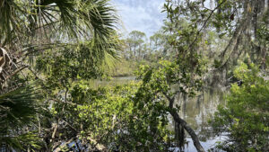
Glimpse of pines on bluffs across a creek South Creek Nature Trail Delight in scenic views and lush vegetation along this well-worn footpath along the bluffs of South Creek at Oscar Scherer State Park.

The South Creek Trail extends a half mile up the creek to the park campground and to the Lake Osprey Picnic Area and nature center.

The barrier-free Lester Finley Trail heads downstream. It has hardened natural surfaces, boardwalks, and pavers, along with many rest stops and “Talking Rangers” that provide interpretation at the push of a button.

Barrier-free path through lush woods Lester Finley Trail A gentle barrier-free nature trail, the Lester Finley Trail along South Creek is an excellent starting point to explore natural habitats within Oscar Scherer State Park.

The Lake Osprey Trail is also accessible. Well graded, it loops its namesake, with plenty of benches, interpretation, and a fishing pier extending into the lake.
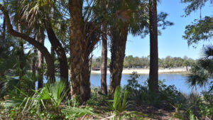
View of lake behind a line of trees Lake Osprey Trail Central to trailhead access at Oscar Scherer State Park, the Lake Osprey Trail is an accessible loop around artesian-fed waters behind the nature center.

Longer Trails

Four major loop trails radiate from Lake Osprey, so many trail users make use of the large parking areas adjoining the nature center and restrooms.

On the far side of the nature center, a bridge leads to the 2.8 mile Green Trail, accessed through the campground via a forest road.

Sign with trail map and colored arrows Colored arrows correspond to trail routes, some of which overlap


Most of the hike on the Green Trail is on a loop through pine flatwoods and scrub. Largely in the sun, this trail is superb for birding.

There is an eagles’ nest in a tall pine, which necessitates seasonal closures of a portion of the loop, and the flutter of Florida scrub-jays amid the diminutive trees.

Tall pine with huge nest in canopy Eagles’ nest in a tall pine


Branching off at the Green Trail is the Orange Trail. This connector crosses a creek and winds along the rim of the floodplain of South Creek, following it upstream.

Passing beneath the Legacy Trail trestle, it reaches a junction for a hike on the biggest loop in the park, the 5 mile Yellow Trail.

Trestle amid palm trees Orange Trail underpass under the Legacy Trail


At the trailhead parking at Lake Osprey, a big sign points out the other access point for the Yellow Trail, which starts out in scrub, shared with the Blue Trail.
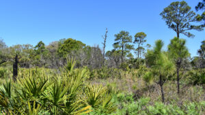
Pine flatwoods Oscar Scherer Yellow Trail On this 4.8 mile loop through expansive scrub and flatwoods, discover hidden streams, ancient trees, and great birding at Big Lake.

Known for Florida scrub-jay sightings, the 1.5 mile Blue Trail turns left where the Yellow Trail crosses the paved Legacy Trail into the northern forests of the park.

Split rail fence with gap and large sign with trail map The Yellow and Blue Trails start at the Lake Osprey trailhead


The 3 mile Red Trail starts in this vicinity as well. When we hiked it two decades ago for 50 Hikes in South Florida, its location against the park perimeter pushed it against a subdivision.

Rooftops aren’t especially compelling scenery. The portion of the loop through pine flatwoods closer to the park road is a much nicer hike.

Tall pines over expanse of saw palmetto The Red Trail crosses an expanse of open pine flatwoods


Biking

Providing direct access to the Legacy Trail, a trailhead lies at the end of a dirt road past Lake Osprey.

Spanning nearly 20 miles from Venice to Sarasota, the Legacy Trail is a popular paved biking route which connects via Venetian Waterway Park to Caspersen Beach on the Gulf of Mexico.

Staying within the park’s boundaries, enjoy an uninterrupted 3.9 mile round-trip ride within natural habitats.

Bike path in pine flatwoods The Legacy Trail Connecting Venice and Sarasota, one of Florida's finest paved trails provides a corridor for biking and hiking along a historic railroad line.

With the exception of the nature trails, hiking trails are open to off-road biking. Markers shaped like bike tires point out the best routes.

Soft sand in scrub habitat is challenging to ride through, especially at the start of the Yellow Trail and the Blue Trail, along with the Red Trail.

It’s best to use the Orange Trail to get to a firmer ride east of the Legacy Trail. Near Big Lake, a trail interconnects with neighboring Scherer Thaxton Preserve.


Trail Map
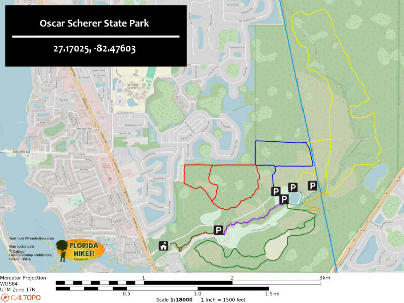
Oscar Scherer Hiking Trails Map
Brown: Lester Finley Trail. Purple: South Creek Trail. Aqua: Lake Osprey Trail. Green: Green Trail. Red: Red Trail. Blue: Blue Trail. Yellow: Yellow Trail. Light Blue: Legacy Trail. Orange: Orange Trail.

Explore More!

Video

Hiking the Yellow Trail at Oscar Scherer State Park


Slideshow

See our photos of Oscar Scherer State Park


Nearby Adventures

Short dock out to a bayfront Historic Spanish Point A prominent peninsula in Little Sarasota Bay at Osprey, Historic Spanish Point fascinates with its layer cake of Florida’s past, both human and floral.
Creek flowing next to a sand path in pine flatwoods Curry Creek Preserve East Amid expanding suburbia in Venice, this 71-acre island of botanical delights circled by a 1.6 mile loop buffers wildflower-rich longleaf pine flatwoods along a mangrove-lined stream.
Slough edged by palms and blooming muhly grass Red Bug Slough Preserve Walk beneath a mature live oak canopy along the rim of a protected waterway within the heart of residential Sarasota.
View of river from forested bluffs Sleeping Turtles Preserve North Named for a feature on old navigational maps, Sleeping Turtles Preserve North provides great views of the Myakka River from its bluffs.

Trail Map (PDF) Reserve Campsite Official Website

  • Author
  • Recent Posts
Sandra Friend & John Keatley
Articles jointly researched, written, and photographed by Sandra Friend & John Keatley, authors and publishers of FloridaHikes.com.
Sandra Friend & John Keatley
Latest posts by Sandra Friend & John Keatley (see all)
  • Baseline Trails - November 7, 2026
  • Hal Scott Yellow Trail - November 3, 2026
  • Hal Scott Preserve - October 28, 2026
Category: Biking, Camping, Canoe & Kayak Rentals, Day Hikes, Florida State Parks, Hikes, Launch Points, Loop Hikes, Nature Centers, Nature Trails, Off Road Biking, Paddling, Parks, Paved Bike Trails, Southwest Florida, TrailsTag: Accessible, Best Camping, Birding, Car Camping, Developed Camping, Dog-friendly, Family-Friendly, Fishing, Florida State Parks, Legacy Trail, Osprey, Picnic, Playgrounds, Primitive Camping, Sarasota, Swimming, Venice, Wildlife Viewing

Sidebar

FarOut Guides

Our comprehensive trail logistics presented on offline maps:

Florida National Scenic Trail (1,500 miles)
Florida Keys Overseas Heritage Trail (108 miles)
Eastern Continental Trail in Florida (92 miles)


We earn a small commission on sales through these links. Thanks for your support!


Our Guidebooks

We’ve written Florida guidebooks for over 25 years. These include Southwest Florida destinations.

Book cover with woman hiking through palms with baby carrier
Book cover of Florida Trail Hikes
The Florida Trail Guide fifth edition

Explore More

Newest Articles for Southwest Florida

View of open water framed by trees Calusa Heritage Trail
Footpath dipping into dampness amid mangroves Nancy Weir Mangrove Preserve
Firebreak and grassy strip through pine flatwoods Scherer Thaxton Preserve
Rounded open water amid grassland Deep Hole

  • Facebook
  • Flickr
  • Instagram
  • Pinterest
  • Substack
  • Vimeo

FIND A TRAIL OR PARK

METROS: Bradenton. Clearwater. Crestview. Daytona Beach. Destin. Fort Lauderdale. Fort Myers. Fort Walton Beach. Gainesville. Jacksonville. Kissimmee. Lakeland. Melbourne. Miami. Naples. Ocala. Orlando. Panama City Beach. Pensacola. Port St. Lucie. Punta Gorda. St. Petersburg. Sanford. Sarasota. Sebring. Stuart. Tallahassee. Tampa. Vero Beach. West Palm Beach.

MULTI-REGION: Atlantic Coastal Ridge. Atlantic Coast. Bartram Trail. Big Bend. East Coast Greenway. Everglades National Park. Florida National Scenic Trail. Gulf Coast. Lake Wales Ridge. WATERWAYS: Indian River Lagoon. Intracoastal Waterway. Kissimmee River. St. Johns River. Withlacoochee River.

NORTHWEST FLORIDA: Altha. Apalachicola. Apalachicola National Forest. Big Bend Scenic Byway. Blackwater River State Forest. Blountstown. Bonifay. Bristol. Bruce. Cantonment. Cape San Blas. Carrabelle. Chattahoochee. Chipley. Crawfordville. DeFuniak Springs. Eastpoint. Ebro. Eglin Air Force Base. Freeport. Fountain. Gulf Breeze. Gulf Islands National Seashore. Holt. Madison. Marianna. Milton. Monticello. Mossy Head. Munson. Navarre. Navarre Beach. Newport. Niceville. Panacea. Panama City . Perdido Key. Ponce De Leon. Port St. Joe. Quincy. Santa Rosa Beach. Sopchoppy. South Walton. St. George Island. St. Marks. St. Marks NWR. Sumatra. Vernon. Wakulla. Wewahitchka. Woodville. WATERWAYS: Apalachicola River. Blackwater Bay. Blackwater River. Chipola River. Choctawhatchee Bay. Choctawhatchee River. Coastal Dune Lakes. Ochlockonee Bay. Perdido River. St. Marks River. Wacissa River. Wakulla River. Yellow River.

NORTH FLORIDA: Alachua. Amelia Island. Archer. Baldwin. Branford. Bronson. Bunnell. Callahan. Cedar Key. Chiefland. Crescent City. Cross City. Cross Creek. Dowling Park. Ellaville. Fanning Springs. Fernandina Beach. Flagler Beach. Fort White. Glen St. Mary. Green Cove Springs. Hawthorne. High Springs. Inglis. Jacksonville Beaches. Jacksonville Northshore. Jasper. Jennings. Keystone Heights. Lake Butler. Lake City. Live Oak.Macclenny. Mandarin. Mayo. Mayport. Micanopy. Middleburg. Old Town. Olustee. Orange Park. Osceola National Forest. Palatka. Palatka-Lake Butler Trail. Palm Coast. Palm Valley. Perry. Ponte Vedra. Rodman. Salt Springs. St. Augustine. Starke. Steinhatchee. Suwannee. Suwannee River Wilderness Trail. Suwannee Springs. Talbot Islands. Timucuan Preserve. Trenton. Waldo. Welaka. White Springs. Williston. Worthington Springs. Yankeetown. WATERWAYS: Santa Fe River. St. Marys River. Suwannee River. Tolomato River. Upper Withlacoochee River.

CENTRAL FLORIDA: Altamonte Springs. Apollo Beach. Apopka. Astatula. Astor. Auburndale. Bartow. Babson Park. Bayport. Belleview. Bithlo. Brandon. Brooksville. Bushnell. Canaveral National Seashore. Cassadaga. Christmas. Chuluota. Citrus Springs. Clearwater Beach. Clermont. Coast to Coast Trail. Cocoa. Cocoa Beach. Cross Florida Greenway. Crystal River. Dade City. De Leon Springs. DeBary. Deland. Deltona. Dunedin. Dunnellon. Edgewater. Enterprise. Eustis. Ferndale. Fort Meade. Frostproof. Geneva. Gibsonton. Haines City. Hernando. Hernando Beach. Holopaw. Homosassa. Inverness. Kenansville. Kissimmee. Lake Mary. Lake Wales. Largo. Leesburg. Lithia. Longwood. Lutz. Maitland. Malabar. McIntosh. Melbourne Beach. Merritt Island. Merritt Island NWR. Mims. Mount Dora. Narcoossee/Lake Nona. New Port Richey. New Smyrna Beach. Nobleton. Oak Hill. Oakland. Ocala National Forest. Ocklawaha. Ocoee. Oldsmar. Orange City. Ormond Beach. Osteen. Oviedo. Paisley. Palm Bay. Plant City. Poinciana. Polk City. Ponce Inlet. Port Orange. Ridge Manor. Riverview. Ruskin. Safety Harbor. Silver Springs. Sorrento. Spring Hill. St. Cloud. Tarpon Springs. Thonotosassa. Titusville . Umatilla. Viera. Walt Disney World. Weeki Wachee. Weirsdale. Wimauma. Windermere. Winter Garden. Winter Haven. Winter Park. Winter Springs. Withlacoochee State Forest. Withlacoochee State Trail. Yeehaw Junction. Zephyrhills. WATERWAYS: Alafia River. Halifax River. Hillsborough River. Lake Apopka. Little Manatee River. Ochlawaha River. Rainbow River. Tampa Bay. Wekiva River. Wekiva River Basin.

SOUTHWEST FLORIDA: Alva. Boca Grande. Cape Coral. Charlotte Harbor. Ding Darling NWR. Ellenton. Englewood. Estero. Immokalee. Marco Island. North Port. Osprey. Palma Sola. Palmetto. Pine Island. Port Charlotte. Sanibel Island. Venice. WATERWAYS: Caloosahatchee River. Manatee River. Myakka River. Pine Island Sound.

SOUTH FLORIDA: Arcadia. Basinger. Big Cypress National Preserve. Big Cypress Seminole Reservation. Big Cypress Swamp. Bowling Green. Clewiston. Everglades City. Indiantown. LaBelle. Lake Okeechobee Scenic Trail. Lake Placid. Lakeport. Moore Haven. Okeechobee. Ortona. Pahokee. Palmdale. Port Mayaca. South Bay. Wauchula. Zolfo Springs. WATERWAYS: Fisheating Creek. Lake Okeechobee. Peace River.

SOUTHEAST FLORIDA: Biscayne Bay. Biscayne National Park. Boca Raton. Boynton Beach. Coconut Creek. Coral Gables. Coral Springs. Davie. Delray Beach. Fellsmere. Flamingo. Fort Pierce. Hobe Sound. Hollywood. Homestead. Indrio. Jensen Beach. Juno Beach. Jupiter. Jupiter Farms. Key Biscayne. North Hutchison Island. Ocean to Lake Greenway. Palm Beach. Palm Beach Gardens. Pompano Beach. Redland. Sebastian. South Hutchinson Island. WATERWAYS: Florida Bay. St. Lucie River.

FLORIDA KEYS: Big Pine Key. Islamorada. Key Largo. Key West. Marathon. Overseas Heritage Trail.


©2006-2026, Sandra Friend & John Keatley | Disclosure | Site Index | Work with Us | Advertise with Us | Terms of Service and Privacy Policy

Florida Hikes PO Box 93 Mims FL 32754 | Contact
